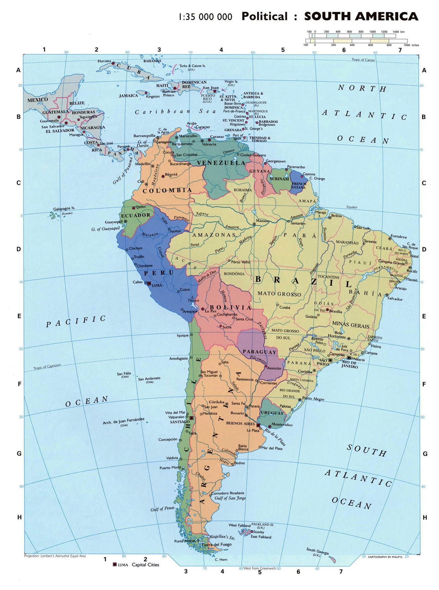
South America encompasses twelve sovereign nations and one overseas territory of France, spanning approximately 17.8 million square kilometers (6.89 million square miles). Brazil serves as the continent's largest nation by area, occupying nearly half of the landmass, while Suriname remains the smallest sovereign state. These geographic dimensions influence everything from biodiversity and climate zones to infrastructure development and resource management across the continent.
Geographic Context and Continental Scope
South America is defined by its diverse topography, ranging from the extensive Andes mountain range in the west to the vast Amazon Basin in the center and the sprawling plains of the Pampas in the south. When calculating the area of South American countries, it is essential to distinguish between sovereign states and overseas territories. While French Guiana is an integral part of the French Republic and follows European Union administrative standards, it is geographically positioned in South America and must be included in any total continental landmass calculation.
The continent's total area accounts for roughly 12% of the Earth's total land surface. Understanding these measurements is vital for researchers, economists, and environmentalists who utilize land-use data to track deforestation in the Amazon, manage agricultural output in the Cerrado, and evaluate the territorial reaches of national maritime boundaries.
Sovereign State Area Breakdown
To facilitate accurate analysis, we classify the twelve sovereign nations by their land area. The variations are significant; the difference in size between Brazil and Suriname is vast, affecting national administrative capabilities, population density distribution, and the ability to monitor remote borders.
The Largest Nations: Continental Giants
Brazil is the undisputed giant of the continent. Covering roughly 8.5 million square kilometers, it dominates the South American landmass. Its size necessitates a complex federal structure to manage environmental regulations and infrastructure projects across different biomes. Following Brazil, Argentina stands as the second-largest country, characterized by its elongated geography that spans multiple climate zones, from the subtropical north to the sub-Antarctic south.
Mid-Sized and Andean Nations
Countries such as Peru, Colombia, and Bolivia represent the mid-tier of South American land area. These nations often grapple with extreme topographical variations. For instance, Peru’s land area is heavily influenced by the high-altitude Andean peaks, the Pacific coastal desert, and the Amazonian lowlands. Similarly, Colombia's geographic position—being the only South American country with both Pacific and Caribbean coastlines—complicates land-use planning and maritime border security.
Smaller Sovereign States
Suriname, Uruguay, and Guyana represent the smaller end of the spectrum. Despite their smaller total area, these nations possess significant exclusive economic zones (EEZs) that extend their geographic influence into the Atlantic Ocean. For these countries, the focus often shifts from sheer land management to the sustainable exploitation of maritime resources and regional trade integration.
Comparative Table of South American Land Areas
The following table provides the approximate total area for each sovereign nation located in South America. Note that these figures reflect land and inland water areas, excluding disputed territories where sovereign control remains a matter of international legal debate.
| Country | Area (sq. km) | Area (sq. miles) |
|---|---|---|
| Brazil | 8,515,767 | 3,287,956 |
| Argentina | 2,780,400 | 1,073,518 |
| Peru | 1,285,216 | 496,225 |
| Colombia | 1,141,748 | 440,831 |
| Bolivia | 1,098,581 | 424,164 |
| Venezuela | 916,445 | 353,841 |
| Chile | 756,102 | 291,933 |
| Paraguay | 406,752 | 157,048 |
| Ecuador | 283,561 | 109,483 |
| Guyana | 214,969 | 83,000 |
| Uruguay | 176,215 | 68,037 |
| Suriname | 163,820 | 63,251 |
Data source: These figures represent recognized national totals as of 2026, including inland lakes and reservoirs.
Factors Influencing Territorial Calculations
Calculating the area of South American countries is not a static endeavor. Several factors can lead to discrepancies in reported data, ranging from the inclusion of inland water bodies to the recognition of contested border regions.
Inland Water and Wetland Classification
Many South American countries contain massive river systems, such as the Amazon, Orinoco, and Paraná rivers. How a country categorizes its inland lakes, permanent wetlands, and river deltas significantly impacts the final "area" figure. For countries like Brazil, the inclusion or exclusion of large-scale hydro-electric reservoirs can fluctuate the total territorial area by several thousand square kilometers.
Border Disputes and Sovereignty
Several regions in South America remain subject to diplomatic discussions regarding borders. While these disputes rarely impede daily governance, they complicate the precise calculation of national territory in international statistics. Researchers must be aware that different global databases (such as those from the United Nations or specific national geographic institutes) may report slightly different totals for countries involved in long-standing border clarifications.
Exclusive Economic Zones (EEZ)
While the land area provides a clear physical footprint, it does not tell the whole story of a country's size. Under the United Nations Convention on the Law of the Sea (UNCLOS), countries like Chile and Peru hold rights to vast maritime territories that dwarf their actual land size. For coastal nations, the "area" is increasingly viewed as a three-dimensional concept involving both terrestrial territory and maritime jurisdictions.
Practical Challenges in Land Management
The sheer scale of these nations creates unique challenges for land-use planning. Remote areas, such as the interior of the Guiana Shield or the deep Amazon, require massive logistical efforts to monitor.
- Environmental Monitoring: Because of the vast distances, governments rely heavily on satellite imagery and remote sensing to monitor illegal logging, mining, and land-use changes.
- Infrastructure Development: Connecting the vast areas of South America via road and rail remains a primary challenge. Countries with large land areas, such as Brazil and Argentina, must invest significantly in transcontinental transport links to facilitate internal trade.
- Biodiversity Preservation: The large area of South America is home to the world’s most significant biodiversity hotspots. National land management policies must balance economic growth with the protection of these vast, often sparsely populated, ecosystems.
Frequently Asked Questions (FAQ)
Which South American country is the largest by area? Brazil is the largest, covering approximately 8.5 million square kilometers. It accounts for nearly 47% of the total land area of the entire South American continent.
Why is French Guiana included in South American area statistics? Although it is an overseas department of France and a region of the European Union, French Guiana is physically located on the South American mainland. It shares borders with Brazil and Suriname, and its landmass is geographically inseparable from the South American land bridge.
Does the area of South American countries change over time? While the actual physical landmass remains stable, reported areas can change due to more accurate surveying technologies (e.g., improved satellite mapping), changes in the definition of territorial waters, or the reclamation of land through engineering projects.
What is the smallest country in South America? Suriname is the smallest sovereign nation in South America, with an area of approximately 163,820 square kilometers.
How do landlocked countries manage their territory differently? Bolivia and Paraguay, the continent's two landlocked nations, focus heavily on developing regional transit corridors. Their territorial management centers on maintaining functional trade routes to the Atlantic and Pacific oceans, as they lack direct maritime access.
Are disputed territories included in these area measurements? Standard geographic datasets usually define areas based on effective administrative control. Disputed zones are often either excluded from specific national totals or attributed to the party currently exercising de facto governance.
Moving Forward with Territorial Data
When analyzing the area of South American countries, it is vital to utilize consistent, primary source data. Organizations such as the national geographic institutes of each respective country and the United Nations Statistics Division provide the most reliable figures. If you are conducting research for economic development, environmental policy, or academic study, always verify whether your data source includes territorial waters and inland water bodies to ensure your comparative analysis is uniform across all nations.