Houston, as the fourth-most populous city in the United States, presents a diverse and expansive landscape where neighborhood characteristics can shift significantly within just a few blocks. When individuals ask about areas to avoid in Houston, they are often seeking to make informed decisions regarding residential safety, tourism, or daily commuting, prioritizing situational awareness and property security in a metropolitan area that covers over 600 square miles.
The Complexity of Houston’s Urban Geography
Houston is unique because it lacks formal zoning laws in the traditional sense, which has historically led to a "patchwork" urban development pattern. In many American cities, specific city districts are clearly demarcated by commercial or industrial zones that buffer residential areas. In Houston, it is not uncommon to find high-end, master-planned luxury communities positioned near industrial sites or older, economically distressed blocks.
Because of this lack of traditional zoning, potential residents and visitors should not rely solely on "general neighborhood reputations." Instead, the most reliable way to evaluate the safety or suitability of an area is to examine current crime statistics provided by the Houston Police Department (HPD) and to understand the socioeconomic trends of specific ZIP codes. Safety is fluid; what might be considered an area to avoid in terms of late-night foot traffic may be a vibrant, popular destination during daylight hours.
Identifying Areas Through Data-Driven Analysis
To determine which parts of the city require extra caution, one must look toward the official crime reporting portals. The City of Houston provides an open-data portal that includes "Part 1" crime statistics—which track violent crimes such as homicide, rape, robbery, and aggravated assault.
Key Metrics for Evaluation
When reviewing data for specific areas, consider these variables:
- Property Crime Rates: These include burglary, larceny-theft, and motor vehicle theft. These are statistically more frequent than violent crimes across the Houston metropolitan area.
- Time-of-Day Patterns: Certain areas experience spikes in activity during late-night hours due to the density of nightlife venues or lack of adequate street lighting.
- Incident Density: Raw numbers can be misleading. A neighborhood with a high volume of retail stores may show high theft counts, which reflects the nature of the business environment rather than the safety of the surrounding residential streets.
Neighborhoods Requiring Enhanced Awareness
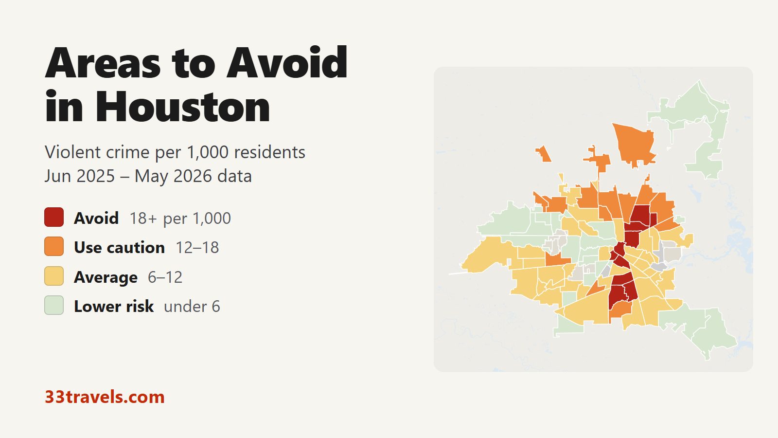
While specific neighborhood borders are subjective, certain areas of Houston have historically appeared in police reports with higher frequencies of reported incidents. These include specific sections of the Near Northside, portions of the Third Ward, and parts of the Sunnyside area.
It is vital to distinguish between "avoiding" an area and simply exercising "enhanced situational awareness." Many of these neighborhoods are currently undergoing significant revitalization, with new housing developments, transit improvements, and public investment aimed at reducing crime. Labeling an entire neighborhood as a place to avoid ignores the families, businesses, and community organizations working to improve those specific sectors.
Comparative Factors in Houston Neighborhoods
When evaluating where to live or visit, consider the following table, which highlights the differences in urban characteristics found across various Houston sectors.
| Neighborhood Sector | Primary Characteristic | Caution Level | Suggested Action |
|---|---|---|---|
| Inner Loop (Central) | High density, nightlife | Moderate | Utilize rideshares late at night; keep belongings secure. |
| Greater Third Ward | Transitional, historic | High | Research specific streets; prioritize gated parking. |
| Northside/Greater Fifth Ward | Industrial/Residential mix | High | Avoid walking alone at night; maintain vehicle security. |
| Energy Corridor (West) | Suburban, corporate | Low | Standard suburban safety measures apply. |
| Clear Lake (Southeast) | Suburban, academic | Low | Monitor for traffic; standard neighborhood vigilance. |
Practical Safety Measures for All Residents and Visitors
Regardless of the neighborhood, the size and layout of Houston necessitate a consistent approach to personal safety. The following practices are recommended by local law enforcement and community safety advocates for navigating the city effectively.
1. Vehicle Safety and Property Protection
Houston is a car-dependent city, and a significant portion of reported crimes involves vehicle break-ins. Never leave laptops, bags, or visible items inside a parked car. Even if an area feels "safe," opportunistic theft is common in high-traffic shopping centers and parks. Using parking garages with security personnel is always preferable to street parking.
2. Situational Awareness in Public Spaces
Whether you are visiting museums in the Museum District or shopping in the Galleria area, remain aware of your surroundings. Avoid distracted walking—looking at a smartphone while traversing parking lots or public walkways makes individuals more vulnerable. If you find yourself in an area that feels uncomfortable or isolated, trust your instincts and relocate to a populated, well-lit space.
3. Leveraging Technology for Safety
Utilize mobile apps provided by local government and emergency services. Many Houston neighborhoods have active "Nextdoor" groups or local Facebook safety pages where residents share real-time information about suspicious activity. While anecdotal evidence should not replace official police data, these platforms are useful for understanding the immediate concerns of a neighborhood.
Addressing Common Safety Questions
Q: Is it safe to use public transportation in Houston? A: Houston’s METRO system, including buses and light rail, is generally safe during operational hours. Like in any major city, keep your belongings close, stay in well-lit areas while waiting at stops, and be aware of your surroundings when riding.
Q: How do I find specific crime data for a neighborhood I am considering? A: Visit the Houston Police Department’s official website. They offer interactive crime maps that allow you to filter by incident type and date range, providing a transparent view of activity in specific city blocks.
Q: Are tourist-heavy areas safer? A: Major tourist hubs, such as the Museum District and the Space Center, generally have higher security presence. However, high foot traffic can also attract pickpockets. Treat these areas with the same level of caution you would apply to any major city center.
Q: What should I do if I feel unsafe in a specific area? A: If you find yourself in a situation that feels threatening, immediately exit the area toward a public space, such as a business or fire station. If you feel you are in immediate danger, dial 911.
Q: Does Houston have "no-go" zones? A: The term "no-go zone" is not used in a formal legal or safety context in Houston. There is no part of the city that is officially restricted to the public. However, there are certainly areas with higher crime rates where extra caution is warranted, particularly for those unfamiliar with the local environment.
The Impact of Urban Revitalization
It is critical to acknowledge that Houston is a city in constant flux. The "areas to avoid" of 2016 are often the "up-and-coming" neighborhoods of 2026. Massive infrastructure projects, such as the redevelopment of bayous and the expansion of the light rail system, have drastically changed the demographics and safety profiles of previously stagnant neighborhoods. Before finalizing a decision about where to reside, visit the area at different times of the day—specifically on a weekday morning and a weekend evening—to get an accurate sense of the neighborhood’s character.
Next Steps for Informed Decision-Making
If you are researching areas in Houston for potential relocation, do not rely on hearsay or outdated forums. Use the following steps to conduct your own due diligence:
- Consult Official Statistics: Spend time reviewing the Houston Police Department’s interactive crime map for the exact street addresses you are interested in.
- Verify School Districts: Often, the quality of a school district serves as a proxy for the stability of a neighborhood. Research the ratings of local public schools.
- Check Local Ordinances: Review the City of Houston’s planning documents to see if there are any major upcoming construction or zoning changes that could impact the neighborhood’s future.
- Engage with Local Residents: Visit local coffee shops or parks in the area. Talking to residents who actually live in the neighborhood provides context that data and statistics cannot capture.
By combining official crime data with local observations and maintaining a high level of situational awareness, you can navigate Houston with confidence and safety. Focus on areas that align with your lifestyle needs, and never hesitate to prioritize your own sense of security when making your choice.