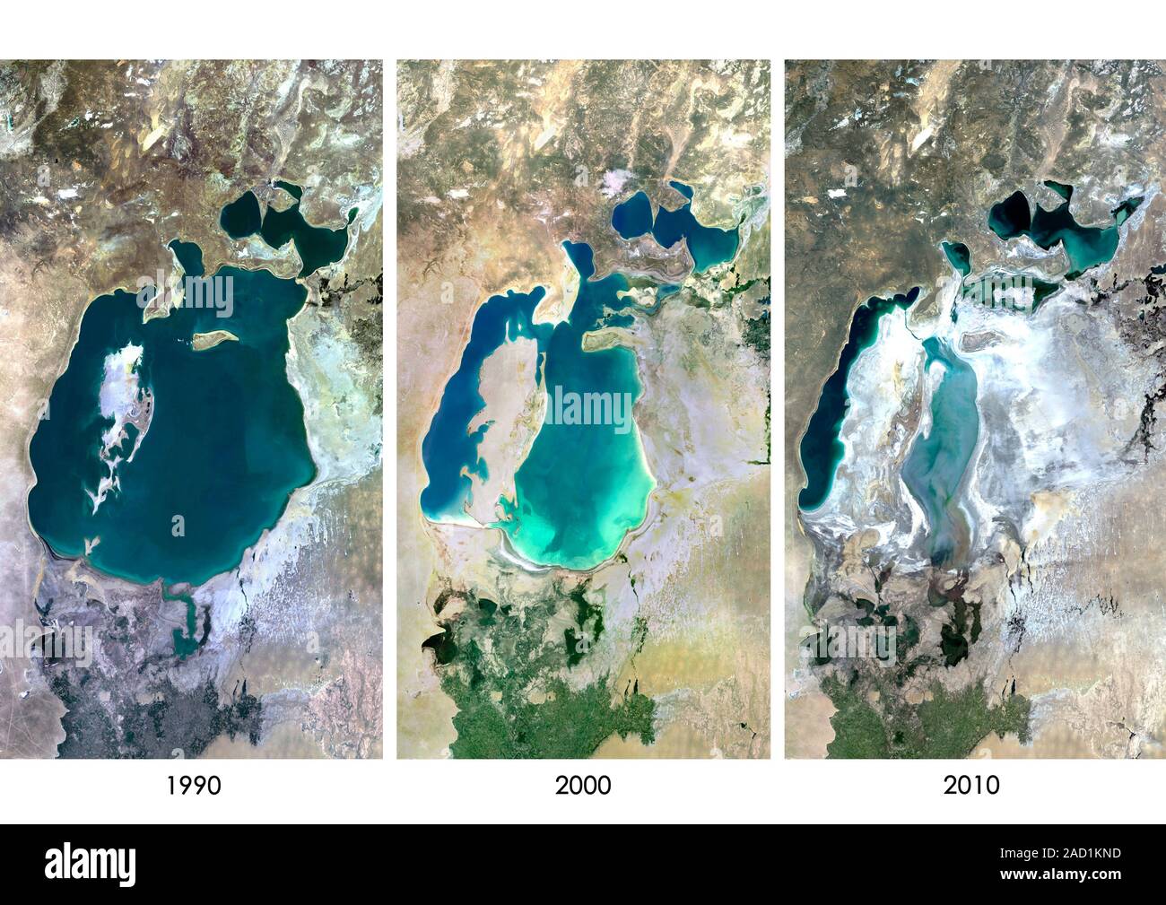
The Aral Sea’s transformation from the world’s fourth-largest inland water body to a fragmented series of hypersaline lakes and a vast new desert represents one of the 20th century's most significant anthropogenic environmental disasters. By 2026, this vanishing basin continues to reshape Central Asian climate patterns, public health, regional geopolitics, and economic survival strategies for millions.
The Historical Inflection Point: Engineering a Catastrophe
The decline of the Aral Sea was not a natural phenomenon but the result of deliberate Soviet economic planning that began in the 1960s. To achieve self-sufficiency in "white gold"—cotton—the Soviet Union initiated massive irrigation projects that diverted the two primary lifelines of the Aral Sea: the Amu Darya and the Syr Darya rivers. Before these diversions, these rivers delivered approximately 55 cubic kilometers of water annually to the basin. By the 1980s, that flow had slowed to a trickle, and in some years, it failed to reach the sea entirely.
The scale of the diversion was staggering. The Karakum Canal, the largest of its kind, stretched over 1,300 kilometers across the desert to transport water to the thirsty cotton fields of Turkmenistan and Uzbekistan. While this turned the desert green and initially boosted the Soviet economy, the hydrologic price was the slow death of the sea. By the late 1980s, the shrinking water level caused the sea to split into two distinct parts: the North Aral (Small Aral) in Kazakhstan and the South Aral (Large Aral) in Uzbekistan.
As of 2026, the historical memory of the unified Aral Sea serves as a cautionary tale of "technocratic hubris." The decision to prioritize short-term agricultural yields over long-term ecological stability fundamentally altered the geographic DNA of the region, turning a maritime climate into a harsh continental one and creating a void that nature has filled with salt and toxic dust.
The Geographic Fragmentation: North vs. South Aral in 2026
The Aral Sea is no longer a single entity, and in 2026, the divergence between its northern and southern remnants is more pronounced than ever. This fragmentation has created two entirely different environmental and economic trajectories for Kazakhstan and Uzbekistan.
The North Aral Sea: A Story of Managed Recovery
In Kazakhstan, the completion of the Dike Kokaral in 2005 marked a turning point. This eight-mile-long dam was designed to prevent water from the Syr Darya from spilling into the desert of the South Aral. By 2026, the North Aral has seen a significant stabilization of water levels. Salinity has dropped to levels that allow for the reintroduction of freshwater fish species, and the shoreline has moved back toward the former port city of Aralsk. While the sea is only a fraction of its original size, the North Aral serves as a successful model of localized ecological restoration through targeted engineering.
The South Aral Sea: The Emergence of the Aralkum Desert
The situation in Uzbekistan is starkly different. The South Aral has further fragmented into eastern and western basins. The eastern lobe is often entirely dry or a seasonal wetland, while the western lobe remains a deep, hypersaline strip of water. What was once the seabed is now the Aralkum Desert, a 60,000-square-kilometer expanse of sand, salt, and residual chemicals. This new desert is the youngest on Earth and serves as the primary source of the "toxic blizzards" that plague the region.
Environmental Consequences and the "Toxic Blizzard" Phenomenon
The vanishing basin has not merely left behind empty space; it has created a dynamic engine for environmental degradation. The most visible manifestation of this is the salt storm. For decades, the Aral Sea acted as a sink for agricultural runoff, which included high concentrations of pesticides (such as DDT), herbicides, and chemical fertilizers used in the upstream cotton fields.
As the water evaporated, these chemicals became concentrated in the sediment. Today, high-velocity winds pick up millions of tons of this toxic dust every year, carrying it as far as the Himalayas and even parts of Europe. For the local population in the Karakalpakstan region of Uzbekistan, these storms are a daily reality. The dust inhalation has led to staggering rates of respiratory diseases, throat cancers, and chronic anemia.
Furthermore, the loss of the sea's thermal mass has permanently altered the local climate. The Aral Sea once acted as a giant air conditioner, tempering the cold winds from Siberia and cooling the region during the scorching summer months. In 2026, the region experiences "continentalization"—summers are hotter and drier, winters are colder and longer, and the growing season has shortened, ironically making the very agriculture that caused the problem even more difficult to sustain.
Socio-Economic Shifts: From Fishing Ports to Landlocked Ruins
The economic devastation following the sea's retreat was total. In the mid-20th century, the Aral Sea supported a thriving commercial fishing industry that employed over 40,000 people and accounted for a significant percentage of the Soviet Union's total fish catch. Port cities like Aralsk and Muynak were bustling hubs with canneries, shipyards, and active harbors.
By the 1990s, these cities were landlocked, some as far as 100 kilometers from the receding waterline. The famous "ship graveyards"—rusting hulls of fishing trawlers sitting in the middle of a desert—became the haunting symbols of this collapse.
In 2026, the economic response has been twofold:
- Adaptation in the North: In Kazakhstan, the revival of the North Aral has allowed some fishing communities to return to the water. Modern processing plants have been built, and fish like pike-perch and bream are once again being exported to Europe.
- Extractive Industry in the South: In Uzbekistan, the dry seabed of the South Aral has become a site for natural gas and oil exploration. Large-scale drilling projects have replaced fishing as the primary economic driver, though these industries provide far fewer local jobs and offer no ecological benefit to the residents of Karakalpakstan.
Regional Geopolitics and Water Diplomacy
The Aral Sea basin is a shared resource involving five Central Asian nations: Kazakhstan, Uzbekistan, Kyrgyzstan, Tajikistan, and Turkmenistan. The "vanishing basin" has fundamentally shaped the diplomatic tensions between these states, primarily revolving around the conflict between energy and agriculture.
Tajikistan and Kyrgyzstan control the headwaters (the "water towers") of the Amu Darya and Syr Darya. Their primary interest is using the water for hydroelectric power, particularly during the winter when energy demand is highest. Conversely, Uzbekistan, Kazakhstan, and Turkmenistan need the water for summer irrigation.
In 2026, the International Fund for Saving the Aral Sea (IFAS) remains the primary vehicle for regional cooperation, though progress is often slow. The region faces a "prisoner's dilemma" regarding water usage. If one nation unilaterally increases its water intake for new agricultural projects or dams (such as the Rogun Dam in Tajikistan), the downstream impact on the Aral Sea remnants and the populations living there is catastrophic. Water diplomacy in 2026 is no longer just about environmentalism; it is a matter of national security and regional stability.
Technical Interventions and Restoration Efforts in 2026
Efforts to mitigate the disaster have evolved from "saving the sea" to "managing the disaster." It is widely accepted by scientists that the Aral Sea will never return to its 1960s level. Instead, the focus is on stabilization and afforestation.
The Great Green Wall of the Aralkum
One of the most ambitious projects in 2026 is the large-scale planting of Black Saxaul trees on the dry seabed. Saxaul is a salt-tolerant shrub native to Central Asia that can survive in the harsh conditions of the Aralkum Desert. These trees serve as a biological barrier, anchoring the soil and preventing the wind from kicking up toxic salt dust. Uzbekistan, with support from international organizations like the United Nations and the World Bank, has successfully planted over 1.5 million hectares of saxaul forest.
Technical Comparison: 1960 vs. 2026
| Feature | 1960 Status | 2026 Status (Estimated) | Impact of Change |
|---|---|---|---|
| Surface Area | ~68,000 sq km | ~7,000 - 10,000 sq km (combined) | 85%+ loss of water surface area. |
| Water Volume | ~1,090 cubic km | < 75 cubic km | Loss of thermal regulation and climate buffer. |
| Salinity | 10 g/L (Brackish) | 100+ g/L (Hypersaline - South) | Total loss of native biodiversity in the South. |
| Primary Economy | Fishing & Shipping | Gas Extraction & Cotton | Shift from renewable to extractive/thirsty crops. |
| Climate Profile | Maritime Influenced | Harsh Continental | Extreme temperature swings and dust storms. |
| Shoreline Location | Adjacent to Aralsk/Muynak | Up to 100km away from former ports | Total displacement of coastal industries. |
The Role of Climate Change in the 2020s
While the initial destruction of the Aral Sea was caused by irrigation, climate change has become the dominant force shaping its future in 2026. The glaciers in the Pamir and Tien Shan mountains, which feed the Amu Darya and Syr Darya, are melting at an accelerated rate.
Initially, this glacier melt provides a temporary surge in river flow, which some policymakers have mistakenly viewed as a "recovery." However, hydrologists warn that "peak water" is approaching. Once the glaciers recede beyond a certain point, the annual flow will drop precipitously, leaving the region with even less water than during the peak Soviet diversion years. This "glacier-fed" reality makes the Aral Sea basin one of the most vulnerable regions in the world to global warming, exacerbating the existing man-made disaster.
FAQ: Understanding the Aral Sea Crisis
1. Is the Aral Sea completely gone?
No, the Aral Sea is not completely gone, but it has fragmented into several smaller water bodies. The North Aral Sea in Kazakhstan has stabilized and even partially recovered due to the Kokaral Dam. The South Aral Sea in Uzbekistan is mostly dry, with only a deep, hyper-saline strip remaining on the western edge.
2. Why can't we just refill the Aral Sea?
Refilling the Aral Sea to its original levels would require stopping nearly all irrigation in Central Asia. This would collapse the economies of Uzbekistan and Turkmenistan, which rely on cotton and agriculture for millions of jobs. Furthermore, the sheer volume of water needed—over 1,000 cubic kilometers—is no longer consistently available due to climate-driven glacier melt and upstream consumption.
3. What is the "Aralkum Desert"?
The Aralkum Desert is the name given to the dry seabed that was once the bottom of the Aral Sea. It covers approximately 60,000 square kilometers and is characterized by salt-encrusted sand. It is now considered the newest desert in the world and is a major source of regional air pollution.
4. Can you visit the Aral Sea today?
Yes, tourism has become a niche industry in both Kazakhstan and Uzbekistan. In Uzbekistan, tourists visit the town of Muynak to see the "ship graveyard" and take multi-day 4WD tours across the dry seabed to reach the receding shoreline of the Western Lake. In Kazakhstan, visitors go to Aralsk to see the recovering North Aral Sea and the local fishing infrastructure.
5. What are the main health risks for people living nearby?
The primary health risks stem from inhaling salt and pesticide-laden dust. This has led to high rates of multi-drug-resistant tuberculosis, chronic obstructive pulmonary disease (COPD), various cancers, and birth defects. The lack of clean drinking water, which has become mineralized and polluted, also contributes to kidney and digestive issues.
Practical Recommendations for Future Resilience
For policymakers and environmental organizations working in the Aral Sea basin in 2026, the focus must shift from nostalgic restoration to pragmatic adaptation.
- Transition to Drip Irrigation: The traditional "flood irrigation" used for cotton is incredibly wasteful. Transitioning the entire basin to modern drip irrigation could save up to 40% of the water currently diverted, potentially allowing more flow to reach the Aralkum for dust suppression and wetland creation.
- Expansion of the Saxaul Forest: Biological stabilization is the most cost-effective way to protect public health. Continued international funding for the "Green Wall" is essential to minimize the impact of toxic dust storms on regional cities like Nukus and Dashoguz.
- Transboundary Cooperation: Kazakhstan and Uzbekistan must move beyond bilateral agreements to a holistic basin-wide treaty that includes Tajikistan and Kyrgyzstan. This treaty must account for the reality of "peak water" and prioritize ecological flow as a non-negotiable component of river management.
- Economic Diversification: Reducing the region’s dependence on water-intensive crops like cotton and rice is the only way to ensure long-term survival. Investing in solar energy and low-water-use manufacturing can provide a future for the youth of the Karakalpakstan and Kyzylorda regions.
The Aral Sea's disappearance serves as a permanent scar on the landscape, but the way the region adapts to this vanishing basin in 2026 will determine whether the disaster remains a tragedy or becomes a masterclass in resilience and reclamation.