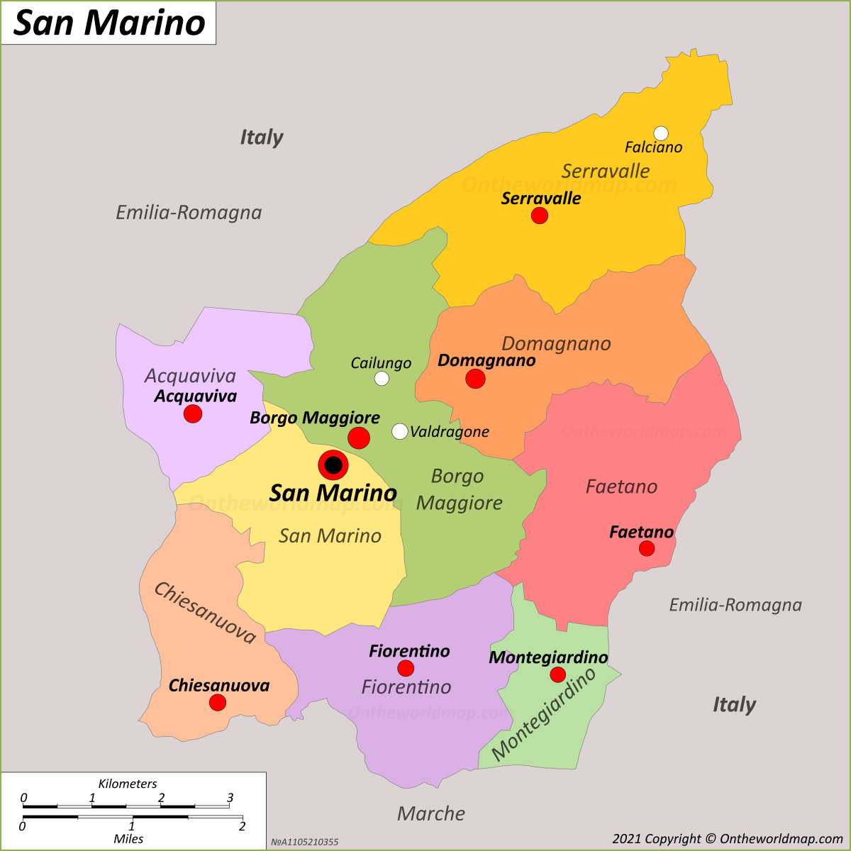
The Republic of San Marino encompasses a total land area of approximately 61.2 square kilometers (about 23.6 square miles). As a microstate entirely landlocked by Italy, its small, mountainous territory is defined by the rugged terrain of the Apennine Mountains, primarily centered around the slopes of Mount Titano, which serves as the country’s geographic and symbolic heart.
Geographical Context and Territorial Extent
San Marino occupies a unique position in Southern Europe. It is one of the world's smallest sovereign nations, ranking behind only Vatican City, Monaco, and Nauru in terms of total surface area. Its borders are defined by the Italian regions of Emilia-Romagna and Marche, specifically the provinces of Rimini and Pesaro-Urbino. Unlike larger nations with diverse topographical zones, San Marino is dominated by the Apennine range, which creates a landscape defined by sharp elevations, deep valleys, and limited flat agricultural land.
The total area of 61.2 square kilometers has remained stable throughout the modern era, as the nation has not sought territorial expansion beyond its historic borders established in the 17th century. The administrative division of the country into nine castelli (municipalities) further illustrates how the population is distributed across this confined space. Each castello—ranging from the capital, City of San Marino, to lower-lying areas like Borgo Maggiore and Serravalle—shares this finite space, necessitating careful land-use planning and urban density management.
Topography and the Role of Mount Titano
The defining feature of San Marino’s geography is Mount Titano. Rising to a peak of 739 meters (2,425 feet) above sea level, the mountain is not merely a geographic landmark but the foundational element of the country's settlement pattern. The capital city is perched on the upper slopes of the mountain, a strategic position chosen centuries ago for its defensibility.
Because the total area is so small, the incline of the terrain plays a significant role in infrastructure and development. A large portion of the nation's 61.2 square kilometers is characterized by significant slope gradients, which limits large-scale industrial farming and dictates the construction methods for housing and transportation networks. The geological composition of this area—largely limestone and sandstone—has also shaped the nation's historical ability to defend itself, as the natural cliffs provided natural fortifications that remain visible in the iconic "Three Towers" of San Marino.
Impact of Small Territorial Scale on Governance
Governing a country with such a restricted land area requires a highly integrated administrative approach. With only 61.2 square kilometers to manage, the Sammarinese government faces specific challenges regarding waste management, energy independence, and logistical planning. Because there is little room for industrial zones to be separated from residential or protected green spaces, urban planning is strictly regulated to preserve the architectural heritage of the historic center while accommodating modern residential needs.
Furthermore, the limited territory necessitates strong cooperation with neighboring Italy. Since the internal area cannot support a full, self-sufficient ecosystem for all goods, resources, and services, San Marino relies on robust cross-border infrastructure. Roads, communication cables, and utility lines must interface seamlessly with the Italian systems surrounding the perimeter of the republic. This geographic reality is the primary driver of the nation’s economic and diplomatic relationship with Italy, as the proximity of the two nations is an inescapable physical fact.
Comparative Scale: San Marino in Perspective
To better understand the relative size of the area, it is helpful to compare it to other entities. San Marino is often described as a "city-state" by nature, though it is legally a republic. Its size is comparable to that of a medium-sized urban district in a major global city, yet it operates as an independent state with its own tax jurisdiction, legislative bodies, and international representation.
Table 1: Comparative Land Area of Select Microstates
| Country/Entity | Total Land Area (approx. sq km) |
|---|---|
| San Marino | 61.2 |
| Vatican City | 0.44 |
| Monaco | 2.02 |
| Liechtenstein | 160.0 |
| Andorra | 468.0 |
As shown in the table, San Marino sits in a specific category of micro-territories that are too large to be considered city-states in the style of Vatican City but are significantly smaller than nations like Andorra or even the city of Liechtenstein.
Land Use and Environmental Preservation
Because the land area is fixed at 61.2 square kilometers, environmental preservation is a high priority. The government has implemented strict zoning laws to prevent urban sprawl, which would quickly consume the limited available space. The preservation of the natural, rocky landscape of Mount Titano is not only an environmental concern but a cultural one; the UNESCO World Heritage status of the historic center and Mount Titano places international obligations on the state to maintain the integrity of its landscape.
There is very little "wasted" land within the republic. The land is either utilized for residential housing, the historic center, commerce, or steep, non-arable terrain that serves as natural landscape protection. Agricultural activities, while present, are constrained by the verticality of the terrain, leading to specialized, high-value farming rather than large-scale monoculture.
Challenges of Infrastructure within a Confined Area
Operating a modern state within such a limited footprint presents unique engineering challenges. Transportation is a primary example; with no rail network and reliance on road-based transport, the traffic flow between the nine castelli must be managed with extreme efficiency to prevent congestion. The elevation differences between the lowest point of the country and the peak of Mount Titano require steep, winding roads that must be maintained to high safety standards to support the constant movement of residents and the significant influx of tourists.
Water and power logistics are similarly defined by the area. San Marino does not possess large internal rivers or natural reservoirs, making the management of water resources a collaborative effort with Italian utility providers. This highlights that while the republic maintains sovereign control over its 61.2 square kilometers, its functional existence is inextricably linked to the surrounding environment of the Italian peninsula.
Frequently Asked Questions
How is the land area of San Marino calculated?
The total area of 61.2 square kilometers is determined by official cadastral surveys conducted by the Sammarinese government. These measurements include the total land mass encompassed by the borders shared with the Italian provinces of Rimini and Pesaro-Urbino.
Does the area of San Marino change due to geological activity?
No, the legal territory of San Marino is defined by international treaty and historical boundary agreements. While minor geological shifts in the Apennines may occur, these do not alter the sovereign land area defined for national and international administrative purposes.
Is all of the 61.2 square kilometers inhabited?
Not all of the land is inhabited. A significant portion of the area, particularly the steeper slopes around Mount Titano and certain protected ecological zones, remains undeveloped or is used for agriculture and forestry to protect the environmental integrity of the republic.
How does the size affect travel within the country?
Because the entire country is only 61.2 square kilometers, it is highly accessible. Traveling from the northernmost point to the southernmost point can often be done in less than 30 minutes by car, depending on traffic, though the winding mountain roads dictate slower travel speeds than flat highway transit.
Can the area of San Marino expand?
San Marino has no current policy or international agenda to expand its borders. The republic is satisfied with its current geographic footprint, which has been consistent for centuries, and focuses on internal development rather than territorial expansion.
Recommendations for Understanding Local Geography
For those interested in studying or visiting the area of San Marino, the best approach is to focus on the division of the nine castelli. By mapping your interest to a specific castello, you can better appreciate the variation in terrain from the historic heights of the City of San Marino to the commercial centers in the valley floors. Visitors should prioritize the use of public transport or personal vehicles equipped for steep inclines, as the verticality of the terrain is the most significant factor that distinguishes San Marino from the flat plains of the surrounding Emilia-Romagna region. Always verify current local road conditions through the official portals of the Republic of San Marino before planning travel through the country’s high-altitude segments.