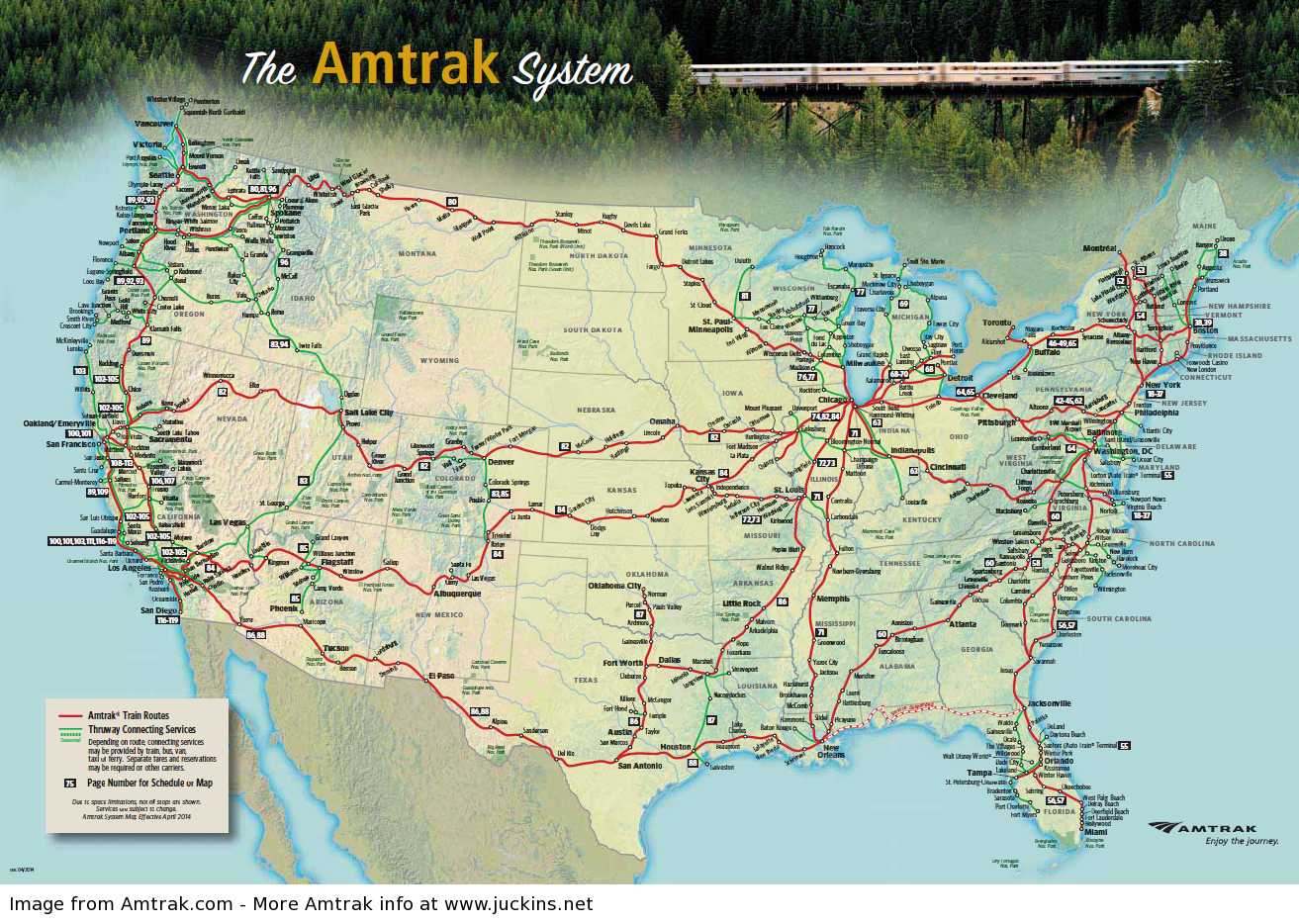
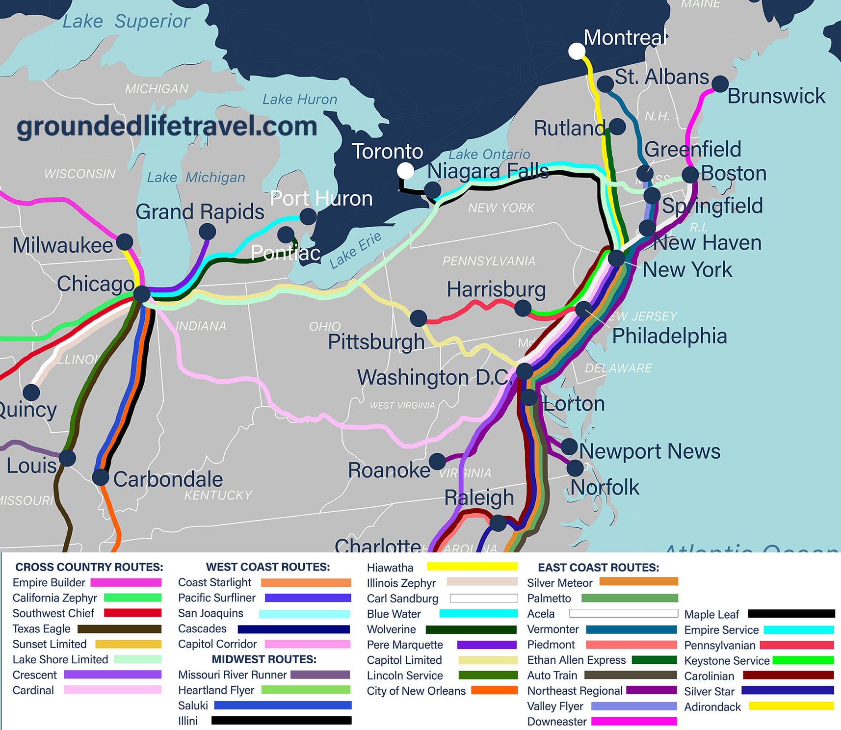
The Amtrak train locator map is a real-time digital tool that allows passengers and rail enthusiasts to track the exact geographical position, current speed, and schedule status of every active Amtrak train across North America. Available via the official Amtrak website and mobile app, it provides live updates on arrivals, departures, and delays to help travelers manage their journeys more effectively.
Understanding the Amtrak Train Locator Map Infrastructure
The Amtrak train locator map is not merely a static graphic; it is a sophisticated data visualization tool built upon a complex technological framework. As of 2026, the system has undergone significant refinements to provide higher accuracy and lower latency. The core of this system relies on Global Positioning System (GPS) units installed on locomotives and cab cars across the entire national network.
This GPS data is integrated with Positive Train Control (PTC) technology, a safety system designed to prevent train-to-train collisions and over-speed derails. By leveraging the data stream from PTC, the locator map can offer granular insights into where a train is located on a specific segment of track. The information is transmitted via cellular and satellite backhaul to Amtrak’s central servers, which then render the data onto a Google Maps-based interface for the public.
For users, this means the map reflects more than just "estimated" times. It reflects the physical reality of the train's movement. If a train is moving at 79 mph through a rural corridor in Nebraska, the map updates that velocity frequently, allowing those waiting at the next station to gauge exactly when the train will pull into view.
Accessing and Navigating the Map in 2026
Accessing the official Amtrak train locator map is straightforward, but the experience differs slightly depending on the platform used. In 2026, Amtrak has optimized the interface for both high-bandwidth desktop environments and low-connectivity mobile scenarios.
Desktop Web Interface
The web-based version, found on the Amtrak official site under the "Track Your Train" tab, offers the most comprehensive view. Users can see the entire United States and parts of Canada, with individual train icons moving across the screen.
- Search Functionality: You can search by train name (e.g., California Zephyr or Empire Builder), train number, or specific station names.
- Filter Options: The desktop version allows users to filter by "Status," showing only those trains that are running on time or those experiencing significant delays.
- Interactive Icons: Clicking on a specific train icon opens a side panel with detailed information including the train number, its last reported speed, the next station stop, and the estimated time of arrival (ETA) versus the scheduled time of arrival.
Mobile App Integration
The Amtrak mobile application integrates the train locator map directly into the booking and boarding workflow. When a passenger has an active ticket, the app frequently prompts them to "Track My Train." This mobile version is designed for quick glances. It utilizes the phone's native GPS to show the user's distance from the approaching train, which is particularly useful for those arriving at a station via rideshare or public transit.
Key Features and Data Points
When using the Amtrak train locator map, several data points are provided to give a full picture of the train's operational status. Understanding these terms is essential for accurate trip planning.
- Train Status Colors: Typically, train icons are color-coded. A green icon generally indicates the train is on time or within a 10-minute window of its schedule. A yellow icon might indicate a moderate delay, while a red icon signifies a significant delay.
- Reported Speed: The map shows the current speed of the locomotive. This is useful for determining if a train is stuck behind freight traffic or if it is "making up time" on a fast stretch of track.
- Station Status: By clicking on a station dot rather than a train icon, users can see a "departure board" style list of all trains expected at that location within the next several hours.
- Route Lines: The map displays the intended path of the train. In 2026, this is especially helpful for new corridors established under the Infrastructure Investment and Jobs Act, where passengers may be less familiar with the specific track geography.
Why Real-Time Tracking Matters for Modern Rail Travel
The importance of the Amtrak train locator map cannot be overstated in a country where passenger trains often share tracks with heavy freight rail. Because freight companies (like Union Pacific or BNSF) own much of the trackage, Amtrak trains are occasionally subject to "freight interference" delays.
Benefits for Passengers
For the passenger, the map eliminates the "black box" of travel. Instead of waiting on a platform wondering why a train hasn't arrived, the passenger can see that their train is currently 15 miles away, moving at 60 mph. This allows for last-minute adjustments, such as grabbing a coffee or staying in a climate-controlled waiting room until the train is minutes away.
Benefits for Families and "Meeters"
Those who are picking up arriving passengers are among the most frequent users of the tracker. By monitoring the map, a "meeter" can time their arrival at the station perfectly, avoiding expensive parking fees or the frustration of waiting at a station during a two-hour delay caused by weather or mechanical issues.
Technical Limitations and Troubleshooting
While the Amtrak train locator map is highly reliable in 2026, it is not infallible. Users should be aware of specific scenarios where the map data might be inaccurate or missing.
- Cellular "Dead Zones": In remote areas, such as the Rocky Mountains or the deserts of the Southwest, locomotives may lose cellular connectivity. When this happens, the train icon may "freeze" on the map or display a message like "Last reported 20 minutes ago." The map will update automatically once the train re-enters a coverage area.
- Server Refresh Rates: The public-facing map often refreshes every 3 to 5 minutes. Therefore, the "live" position may actually be a few miles behind the train's true location if it is traveling at high speed.
- Data Lag in the App: If the mobile app is not updated to the latest version, the mapping API may fail to load. Always ensure you are running the most recent version of the Amtrak app for the best tracking performance.
- Ghost Trains: Occasionally, a train might disappear from the map if its GPS unit malfunctions. In these rare cases, the station staff or the Amtrak automated phone system (1-800-USA-RAIL) will have the most accurate manual updates.
Official vs. Third-Party Tracking Tools
While Amtrak provides the official tool, several third-party developers have created alternative maps that utilize the same "open data" feed provided by Amtrak. In 2026, these tools remain popular with "foamers" (railfans) and frequent travelers for different reasons.
| Feature | Official Amtrak Map | Third-Party Tools (e.g., TransitDocs, ASM) |
|---|---|---|
| User Interface | Polished, user-friendly, branded. | Technical, data-heavy, minimalist. |
| Data Depth | Focuses on ETA and schedule. | Often shows historical delay trends and consist info. |
| Platform | Web and App. | Mostly web-based/browser. |
| Reliability | High, supported by Amtrak IT. | Depends on the hobbyist developer. |
| Cost | Free. | Free (usually ad-supported). |
| Best For | Casual passengers and families. | Power users and rail enthusiasts. |
Third-party maps like TransitDocs or the Amtrak Status Maps (ASM) often provide "heat maps" of delays or allow users to see the history of a specific train number over the last week. This historical context is invaluable for travelers trying to decide if a 30-minute connection in Chicago is realistic based on the recent performance of the incoming train.
Deep Dive: How GPS and PTC Improve Accuracy in 2026
The accuracy of the Amtrak train locator map in 2026 is significantly higher than it was a decade ago. This is largely due to the full implementation of Positive Train Control (PTC) across all Class I railroads. PTC requires the locomotive to constantly "know" its exact position relative to track switches, signals, and other trains.
By tapping into this safety-critical data, Amtrak's tracking servers can pinpoint a train within a few meters. Furthermore, 2026 sees the widespread use of 5G and LEO (Low Earth Orbit) satellite internet on trains. This has drastically reduced the number of "dead zones." Even in the middle of the North Dakota prairie, trains can now maintain a steady data connection, ensuring that the icon on your screen moves smoothly rather than jumping in large increments.
Practical Tips for Using the Map Effectively
To get the most out of the Amtrak train locator map, consider these expert tips:
- Check the "Last Update" Timestamp: Always look at the bottom of the train info panel to see when the data was last refreshed. If it was more than 10 minutes ago, the train is likely in a tunnel or a remote area.
- Use the Map for "Connecting" Anxiety: If you are on a train and worried about making a connection, use the map to track the other train you are supposed to catch. If both are delayed, you might still make your connection.
- Cross-Reference with Station Information: The map shows where the train is, but the "Station" tab on the Amtrak website shows which track it will arrive on. Use both for a seamless experience.
- Monitor the Speed: If a train is traveling at 0 mph between stations, it is likely waiting for a freight train to pass. This provides more context than a simple "delayed" status.
Common Questions Regarding Train Tracking
Is the Amtrak train locator map available for all routes?
Yes, the map covers the entire Amtrak network, including the high-speed Acela in the Northeast Corridor, long-distance routes like the Southwest Chief, and state-supported corridors like the Pacific Surfliner or Hiawatha. It also includes Amtrak Thruway bus connections in many instances, though these are sometimes tracked with less precision than the trains.
Why is my train showing as "On Time" when the map shows it isn't moving?
Scheduled times are based on the next station stop. A train might be stopped between stations due to a signal, but if it has enough "padding" (extra time) in the schedule, it can still arrive at the next station "on time." The locator map shows the physical reality, while the status shows the schedule reality.
Can I track VIA Rail trains on this map?
The Amtrak map occasionally shows VIA Rail (Canada) trains that operate on shared corridors or in partnership with Amtrak (like the Maple Leaf), but for full tracking of Canadian rail, it is best to use VIA Rail’s own dedicated tracking tools.
Does the map show the train's consist (number of cars)?
The official Amtrak train locator map usually does not show the specific locomotive numbers or the number of passenger cars. However, some third-party tracking sites mentioned earlier do pull this data from railfan reports or public equipment logs, which can be interesting for those who want to know if they are riding in a specific type of car, like a Superliner or a Venture carriage.
Future of Train Tracking
By the end of 2026 and heading into 2027, Amtrak is expected to integrate augmented reality (AR) features into the mobile version of the locator map. This would allow a passenger standing on a platform to point their phone camera down the tracks and see a digital overlay showing exactly how many miles away the train is and its projected path. This continued investment in transparency and technology reflects Amtrak’s goal of making rail travel a more competitive and stress-free alternative to driving or flying.
Recommendation for Travelers
Before heading to the station, always check the Amtrak train locator map at least 60 minutes prior to your scheduled departure. Even if you received a text notification about a delay, the map provides the visual context needed to understand if that delay is growing or shrinking. For those on long-haul journeys, keeping the map open in a browser tab is the best way to stay informed about your progress across the country.