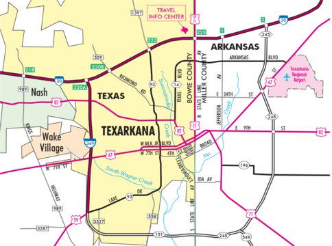
The drive from Atlanta, Texas, to Texarkana, Texas, is a straightforward 26-mile journey north primarily via US Highway 59. In 2026, this commute typically takes between 30 and 40 minutes, depending on traffic within the Texarkana city limits. It serves as a vital regional link for employment, healthcare, and retail in the Ark-La-Tex area.
Distance and Drive Time Overview
The geographic distance between Atlanta, TX (located in Cass County) and Texarkana, TX (located in Bowie County) is approximately 26.5 miles when measuring from city center to city center. Because both municipalities are situated in the Piney Woods region of Northeast Texas, the terrain is characterized by gently rolling hills and dense pine forests, which provides a scenic but direct transit corridor.
For a standard passenger vehicle, the drive time is remarkably consistent. During off-peak hours, a motorist can complete the trip in roughly 30 minutes. However, during morning rush hours (7:00 AM to 8:30 AM) and evening return times (4:30 PM to 6:00 PM), drivers should account for an additional 10 to 15 minutes. The primary bottleneck usually occurs as US-59 transitions into the urban environment of Texarkana, specifically near the intersections with Loop 151 and the Interstate 30 interchange.
Factors Influencing Travel Time
Several variables can impact the duration of the trip between these two East Texas hubs:
- Agricultural and Industrial Traffic: US-59 is a major corridor for the timber industry. Large log trucks are common, and while they generally maintain highway speeds, they can slow down traffic on inclines or near mill entrances.
- Weather Conditions: Northeast Texas is prone to heavy seasonal thunderstorms and occasional morning fog. Given the high speeds permitted on US-59, reduced visibility or hydroplaning risks can necessitate a significant reduction in speed.
- Road Maintenance: As part of the ongoing I-369 development projects in 2026, periodic lane closures or median work may be encountered between Atlanta and the Texarkana loop.
The Primary Route: US Highway 59 and the I-369 Corridor
The most efficient and heavily trafficked route is US Highway 59 North. This road is a four-lane divided highway for the entire stretch between Atlanta and Texarkana. In recent years, much of this segment has been designated as part of the Interstate 30/Interstate 369 corridor, reflecting its importance as a high-priority freight and travel lane.
Navigating the Route
Starting in downtown Atlanta, drivers head north on Loop 59 or directly onto the US-59 main lanes. The route passes through the small community of Queen City almost immediately. From Queen City, the road opens up into a high-speed rural highway. The speed limit is generally 70-75 mph in rural sections but drops significantly as you approach the Texarkana city limits.
One of the key landmarks on this route is the crossing near the Sulphur River. This area is lower in elevation and can be prone to localized fog. After crossing the river, you enter Bowie County. As you approach Texarkana, you have two primary options for entering the city:
- Stay on US-59 (South Stateline Avenue): This takes you directly into the heart of Texarkana, providing access to the downtown historic district and the Texas-Arkansas border.
- Transition to I-369/Loop 151: This bypass allows travelers to circle the western edge of the city, providing faster access to the Richmond Road shopping districts, the Texas A&M University-Texarkana campus, and the Interstate 30 corridor heading toward Dallas or Little Rock.
Alternative Routes and Backroads
While US-59 is the fastest path, some residents and travelers prefer alternative routes to avoid highway traffic or to reach specific rural destinations between the two cities.
FM 2148 and FM 559
For those traveling from the western side of Atlanta toward the northern parts of Texarkana (near Pleasant Grove), taking Farm-to-Market roads can sometimes be a quieter alternative. These roads are typically two-lane paved surfaces. While the speed limits are lower (usually 55 mph), they offer a more direct path to certain residential areas in Bowie County without having to navigate the main commercial congestion of US-59.
TX-43 to US-67
Another alternative involves taking Texas State Highway 43 toward the northeast, eventually connecting with US-67. This is significantly less direct for those going to central Texarkana but is often used by locals living in the rural areas of northeast Cass County. This route is primarily used for local access rather than through-travel, as it adds approximately 15 minutes to the total journey.
Public Transportation and Transit Options
Public transit between Atlanta and Texarkana is limited compared to larger metropolitan areas, but there are dedicated services for residents who do not drive.
TRAX Rural Public Transportation
The Ark-Tex Council of Governments (ATCOG) operates the TRAX system, which provides demand-response transit services for the region. As of 2026, TRAX remains the primary lifeline for residents needing to travel between Cass and Bowie counties for non-emergency medical appointments, social services, or employment.
- Eligibility: The service is open to the general public, though it is heavily utilized by seniors and individuals with disabilities.
- Booking: Passengers must generally schedule their rides at least 24 to 48 hours in advance. This is not a "fixed-route" bus system where you can wait at a stop; it is a curb-to-curb service.
- Cost: Fares are modest, typically ranging from $2.00 to $5.00 per one-way trip, depending on the specific distance and passenger status.
Commercial Services and Ridesharing
Ridesharing platforms like Uber and Lyft do operate in Texarkana, but their availability in Atlanta, TX, is often sparse. A traveler might successfully find a ride from Texarkana to Atlanta, but finding a driver available for an immediate pickup in Atlanta for a trip to Texarkana can be challenging. It is often necessary to pre-schedule these rides or rely on local taxi companies based out of Texarkana that are willing to travel to Atlanta for a pickup, though this incurs a higher cost due to the "deadhead" miles the driver must travel.
Commuting Economics in 2026
For many, the trip from Atlanta to Texarkana is a daily necessity. Atlanta serves as a "bedroom community" where housing costs are often lower than in Texarkana, leading to a significant daily workforce migration.
Fuel and Maintenance Costs
With a round-trip distance of approximately 53 miles, a daily commuter driving a vehicle that averages 25 miles per gallon will consume roughly 2.1 gallons of fuel per day. At 2026 price estimates (approximately $3.35 per gallon), the daily fuel cost is roughly $7.00. Over a standard 21-day work month, this totals $147.00 in fuel alone.
When factoring in the IRS standard mileage rate for 2026, which accounts for wear and tear, insurance, and depreciation, the "true cost" of the commute is significantly higher. Commuters should ensure their vehicles are well-maintained, particularly tires and braking systems, given the high-speed nature of US-59 and the frequent presence of heavy trucks.
Comparison of Travel Methods
| Method | Average Time | Estimated Cost (One-Way) | Flexibility |
|---|---|---|---|
| Personal Vehicle | 30–35 Mins | $3.50 (Fuel only) | Highest - Leave anytime |
| TRAX Transit | 60–90 Mins | $2.00 – $5.00 | Low - Requires 24h notice |
| Rideshare (Uber/Lyft) | 35 Mins | $45.00 – $65.00 | Moderate - Availability varies |
| Carpooling | 35 Mins | $1.75 (Split fuel) | Moderate - Fixed schedule |
Safety and Road Conditions
Safety is a paramount concern on the US-59 corridor. Because this is a major North American trade route (eventually forming part of the I-69 system), the mix of high-speed passenger cars and heavy freight requires constant driver vigilance.
Deer and Wildlife
The Piney Woods region is home to a dense white-tailed deer population. In the early morning hours and after sunset, deer-vehicle collisions are a significant risk on the highway between Atlanta and Texarkana. Drivers are advised to use high beams when appropriate and to be particularly cautious near the Sulphur River bottomlands.
Infrastructure Developments
In 2026, the Texas Department of Transportation (TxDOT) continues to upgrade sections of US-59 to meet interstate standards. These improvements include:
- Grade Separation: Replacing at-grade intersections with overpasses to reduce "T-bone" accidents.
- Improved Frontage Roads: Providing safer access to local businesses without disrupting the flow of highway traffic.
- Bridge Reinforcement: Ensuring that the bridges over regional waterways can handle increased freight weight limits.
Points of Interest Along the Way
While the drive is short, several locations provide a reason to stop or serve as helpful landmarks for navigation.
Atlanta State Park
Located just a few miles off the main path toward the west of US-59, Atlanta State Park sits on the shores of Wright Patman Lake. It is a popular spot for commuters and travelers to stop for recreation. The park offers towering pines, hiking trails, and access to the lake for fishing and boating.
Wright Patman Lake
The highway crosses several areas that feed into Wright Patman Lake. This massive reservoir provides the primary water source for Texarkana and surrounding areas. The area around the lake is a designated wildlife management area, making it a prime spot for birdwatching, though drivers should remain focused on the road as the highway can narrow slightly on bridge approaches.
The "State Line" Experience
Upon arriving in Texarkana, one of the most famous subjects is Stateline Avenue. While US-59 turns into Stateline, you are literally driving with the driver's side in Texas and the passenger side (of a northbound car) in Arkansas. The Post Office and Federal Building, located at 500 N. State Line Ave, is the only federal building in the U.S. situated in two states.
Relocation and Regional Connectivity
For those considering moving to Atlanta and commuting to Texarkana, or vice versa, the regional connectivity is a major selling point. Atlanta offers a quieter, small-town atmosphere with a lower cost of living, while Texarkana provides the "big city" amenities including the Central Mall, various hospital systems (CHRISTUS St. Michael and Wadley Regional), and higher education institutions.
The "Atlanta-Texarkana" corridor is increasingly viewed as a single economic unit. As Texarkana expands southward, the gap between the two cities is effectively shrinking in terms of travel time and accessibility. The ongoing conversion of US-59 into I-369 is expected to further stabilize property values in Cass County by making the commute safer and more predictable for those working in Bowie County or across the border in Miller County, Arkansas.
Frequently Asked Questions
What is the speed limit on US-59 between Atlanta and Texarkana?
In rural sections, the speed limit is typically 75 mph. However, as you pass through Queen City or approach the Texarkana city limits, the speed limit drops to 65 mph and eventually 45-55 mph in urban areas. Always watch for posted signage, as enforcement is frequent near the county line.
Is there a toll road between Atlanta, TX and Texarkana, TX?
No, there are currently no toll roads on this route. All segments of US-59 and the local Farm-to-Market roads are public, non-tolled highways maintained by the Texas Department of Transportation.
Are there any major construction projects planned for 2026?
Yes, the I-369 expansion is an ongoing multi-year project. Travelers should expect periodic construction zones north of Queen City as TxDOT works to upgrade the highway to full interstate standards, which includes adding more robust shoulders and improving exit ramps.
Is there a bus service like Greyhound between the two cities?
There is no direct Greyhound station in Atlanta, TX. The nearest Greyhound terminal is located in Texarkana. For travel between the two specifically, residents rely on the TRAX rural transit system or personal vehicles.
How does the weather affect the commute?
Northeast Texas experiences high humidity and frequent rainfall. Heavy downpours can cause localized hydroplaning on US-59. While snow is rare, "black ice" can form on the Sulphur River bridges during winter cold snaps, which may lead to temporary road closures or hazardous conditions.
Can I bike from Atlanta to Texarkana?
While physically possible, it is not recommended. US-59 is a high-speed highway with heavy industrial truck traffic and no dedicated bike lanes. Cyclists would have to use backroads (like FM 2148), which increases the distance significantly and still lacks wide shoulders for safety.
Final Recommendations for Travelers
If you are planning to travel from Atlanta, TX to Texarkana, TX in 2026, the best approach is to utilize US-59 North. To ensure a smooth trip, aim to depart before 7:30 AM if you have a morning appointment in Texarkana to avoid the congestion at the Loop 151 interchange. Always check local weather reports for fog warnings, particularly during the autumn and spring months, as visibility near the river bottoms can drop suddenly. For those without a vehicle, contact the Ark-Tex Council of Governments at least two days in advance to secure a seat on the TRAX transit system.