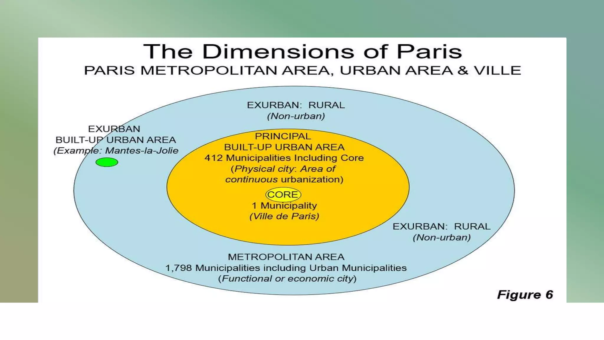
In the context of French urban planning, an "arr" or arrondissement is a municipal administrative district. Paris is divided into 20 such districts, arranged in a clockwise spiral starting from the city center, often referred to as the "escargot" (snail). These districts serve as the primary units for local governance, postal coding, and urban identity, each possessing its own mayor, town hall, and distinct socio-economic character.
While the term "arrondissement" can also refer to subdivisions of French departments (administrative levels above the city), in the specific context of Paris, it almost exclusively refers to these 20 municipal sectors. As of 2026, this structure remains the bedrock of Parisian life, balancing centralized city management with localized community representation. Understanding the definition and structure of these districts is essential for navigating the city’s legal requirements, real estate markets, and cultural landscape.
The Historical Evolution of Parisian Arrondissements
The current structure of Paris did not emerge overnight; it is the result of centuries of political shifts and urban expansion. The concept of the arrondissement was first established in 1795. At that time, Paris was divided into only 12 districts. These were numbered from west to east, with nine on the Right Bank (Rive Droite) and three on the Left Bank (Rive Gauche).
The most significant transformation occurred in 1860 under the reign of Napoleon III and the direction of Baron Georges-Eugène Haussmann. To accommodate the rapidly growing population and to integrate the surrounding suburban communes—such as Montmartre, Belleville, and Vaugirard—the city limits were expanded to the Thiers wall. This expansion necessitated the creation of eight new districts, bringing the total to 20.
A fascinating piece of historical trivia involves the numbering of these districts. In the original proposal, the wealthy 16th arrondissement was slated to be the 13th. However, the residents of that area objected because "marrying at the town hall of the 13th" was a colloquialism for living in sin (since there were only 12 districts previously). To satisfy the elite, the numbering was changed to the spiral pattern we recognize today, ensuring the 13th remained in a then-working-class area on the Left Bank.
The "Escargot" Layout: Navigating the Spiral
The physical structure of Paris is defined by its numerical logic. If you look at a map of the city, the 1st arrondissement (1er) is located at the center of the city on the Right Bank, encompassing the Louvre and the Tuileries. From there, the numbers move in a clockwise spiral, expanding outward.
The Inner Spiral (1st through 11th)
These districts constitute the historic core of the city. They are generally characterized by older architecture, higher density, and major tourist landmarks.
- The 1st to 4th: These represent the medieval and Renaissance heart of Paris. In 2020, an administrative reform grouped these four districts into a single sector known as Paris Centre, though they retain their distinct postal codes (75001–75004).
- The 5th to 7th: Located on the Left Bank, these are historically intellectual and aristocratic hubs, containing the Latin Quarter and the Eiffel Tower.
- The 8th to 11th: These districts on the Right Bank house the major business centers (the 8th), the grand boulevards (the 9th), and the vibrant, high-density residential and nightlife corridors (the 10th and 11th).
The Outer Spiral (12th through 20th)
The outer ring consists of districts that were largely annexed in 1860. These areas are typically more residential and often contain larger green spaces, such as the Bois de Vincennes (12th) and the Bois de Boulogne (16th). These districts provide a transition between the dense urban center and the surrounding "Petite Couronne" (inner suburbs).
Administrative Structure and Governance
The governance of Paris is unique due to its status as both a commune (city) and a department. The structure is governed by the PLM Law (Paris, Lyon, Marseille), which outlines how these large cities are managed.
The Role of the District Mayor
Each arrondissement has its own town hall (mairie d'arrondissement) and a district mayor. However, unlike the central Mayor of Paris, the district mayors have limited executive power. Their primary responsibilities include:
- Local Services: Managing local nurseries, primary schools, and sports facilities.
- Public Consultation: Reviewing local urban planning projects and building permits before they are sent to the central city council.
- Civil Registry: Handling births, marriages, and deaths within the district.
- Housing: Allocating a portion of social housing units within their boundaries.
The district council (conseil d'arrondissement) is composed of members elected during municipal elections. Some of these members also sit on the Council of Paris, which is the central governing body that decides the city's overall budget, major infrastructure projects, and tax rates.
The Paris Centre Reform
Effective since June 2020, the 1st, 2nd, 3rd, and 4th arrondissements were merged into a single administrative unit called Paris Centre. This was done to streamline administration and provide a more balanced electoral weight compared to the more populous outer districts like the 15th or 20th. Residents of these four districts now vote for a single mayor and council, and they share a central town hall (the former town hall of the 3rd arrondissement). Despite this, the geographical and cultural identities of the individual districts are preserved for postal and statistical purposes.
The Quartier System: Sub-Districts of Paris
To understand the structure of Paris even more deeply, one must look below the level of the arrondissement. Every arrondissement is legally divided into four quartiers administratifs (administrative quarters). In total, there are 80 such quarters in Paris.
Each quarter has its own specific history and atmosphere. For example, the 18th arrondissement contains the Quartier de Clignancourt, the Quartier des Grandes-Carrières, the Quartier de la Goutte-d'Or, and the Quartier de la Chapelle. While the "arrondissement" is the unit for administration, the "quartier" is often the unit for community identity. When Parisians speak about where they live, they are just as likely to mention their quarter (e.g., "I live in Marais" or "I'm near Canal Saint-Martin") as they are to give the arrondissement number.
Comparative Overview of Parisian Districts (Data as of 2026)
The following table provides a snapshot of the diversity across the 20 arrondissements, highlighting their primary characteristics and landmarks.
| Arrondissement | Common Name | Primary Character | Key Landmarks |
|---|---|---|---|
| 1er | Louvre | Historic/Tourist Core | Musée du Louvre, Palais Royal |
| 2e | Bourse | Financial/Textile | Palais Brongniart, Rue Montorgueil |
| 3e | Temple | Artsy/Residential | Musée Picasso, Northern Marais |
| 4e | Hôtel de Ville | Historic/Gay Village | Notre-Dame, Centre Pompidou |
| 5e | Panthéon | Academic/Intellectual | Sorbonne, Panthéon |
| 6e | Luxembourg | Posh/Literary | Jardin du Luxembourg, Saint-Germain-des-Prés |
| 7e | Palais-Bourbon | Aristocratic/Political | Eiffel Tower, Musée d'Orsay |
| 8e | Élysée | Luxury/Commercial | Champs-Élysées, Arc de Triomphe |
| 9e | Opéra | Commercial/Theatrical | Opéra Garnier, Galeries Lafayette |
| 10e | Entrepôt | Vibrant/Transit Hub | Canal Saint-Martin, Gare du Nord |
| 11e | Popincourt | Nightlife/Residential | Place de la Bastille, République |
| 12e | Reuilly | Residential/Green | Opéra de la Bastille, Bois de Vincennes |
| 13e | Gobelins | Modern/Asian Hub | Bibliothèque François Mitterrand, Chinatown |
| 14e | Observatoire | Residential/Artistic | Montparnasse, Catacombs |
| 15e | Vaugirard | Family-oriented/Dense | Tour Montparnasse, Parc André Citroën |
| 16e | Passy | Wealthy/Diplomatic | Trocadéro, Bois de Boulogne |
| 17e | Batignolles | Diverse/Evolving | Palais de Justice, Parc Martin Luther King |
| 18e | Butte-Montmartre | Bohemian/Touristic | Sacré-Cœur, Moulin Rouge |
| 19e | Buttes-Chaumont | Family/Parks | Parc des Buttes-Chaumont, Cité des Sciences |
| 20e | Ménilmontant | Gritty/Multicultural | Père Lachaise Cemetery, Belleville |
Practical Implications for Residents and Visitors
For anyone interacting with the city, the "arr" designation is the most important piece of geographic data. It influences everything from the cost of rent to the availability of certain services.
Postal Codes and Addressing
The French postal code system for Paris is highly predictable. Every code begins with the prefix 750, followed by the two-digit number of the arrondissement.
- A resident in the 5th arrondissement has the postal code 75005.
- A resident in the 16th arrondissement has the postal code 75016. The only minor exception is the 16th, which is so large it is occasionally subdivided into 75016 and 75116 for mail routing.
Real Estate and Cost of Living
The structure of Paris creates "concentric circles" of value. Generally, the lower the number (the closer to the 1st), the higher the price per square meter. However, the "West Side" (6th, 7th, 8th, and 16th) remains the most expensive residential sector due to historical prestige and architectural preservation. In contrast, the "East Side" (19th and 20th) has historically been more affordable, though intense gentrification throughout the 2020s has narrowed this gap significantly.
School Districts (Carte Scolaire)
For families living in Paris, the arrondissement determines the "sector" for public schools. Children are typically assigned to a school based on their home address within the district. While "dérogations" (exceptions) exist, the reputation of a district's schools is a primary driver of property values. The 5th, 6th, and 16th arrondissements are particularly noted for their high-performing public lycées (high schools).
Common Misconceptions and Troubleshooting
Misconception 1: The "Paris Centre" merger changed postal codes. This is incorrect. While the 1st through 4th arrondissements share a single mayor, they maintain their original postal codes (75001–75004). If you are writing an address, you should still use the specific code for that district.
Misconception 2: All arrondissements are the same size. There is a massive disparity in size and population. The 1st arrondissement is relatively small and has a low residential population because it is dominated by museums and government buildings. The 15th arrondissement, by contrast, is the most populous, housing nearly 230,000 residents—comparable to the population of a major city like Bordeaux or Lille.
Misconception 3: The arrondissements extend into the suburbs. The 20 arrondissements stop strictly at the Boulevard Périphérique (the ring road). Anything beyond this road is part of the "Banlieue" (suburbs) and belongs to different departments (92 Hauts-de-Seine, 93 Seine-Saint-Denis, or 94 Val-de-Marne). Even if a suburb is very close to the city center, it will have a five-digit postal code starting with 92, 93, or 94 rather than 75.
Frequently Asked Questions
What is the most populated arrondissement in Paris?
As of 2026, the 15th arrondissement (Vaugirard) remains the most populous. It is a massive residential sector in the southwest of the city, known for being family-oriented and containing a mix of Haussmannian and modern high-rise architecture. Its population density is one of the highest in Europe.
Why is the 13th arrondissement famous?
The 13th is primarily known for two things: the Bibliothèque Nationale de France (François Mitterrand) and its vibrant Chinatown (Quartier Asiatique). Located in the southeast, it features more modern urban planning than the historic center, including many high-rise apartment buildings constructed in the 1960s and 70s.
How do I know which arrondissement a landmark is in?
The easiest way is to look at the last two digits of the postal code. If you see a museum with the code 75007, it is in the 7th. If a restaurant is in 75011, it is in the 11th. On street signs in Paris, the arrondissement number is also typically displayed on the blue enamel sign above the street name.
What does "Rive Gauche" and "Rive Droite" mean in relation to arrondissements?
The Seine River splits Paris into two halves. The Rive Gauche (Left Bank) is south of the river and includes arrondissements 5, 6, 7, 13, 14, and 15. The Rive Droite (Right Bank) is north of the river and includes 1, 2, 3, 4, 8, 9, 10, 11, 12, 16, 17, 18, 19, and 20. Historically, the Right Bank was associated with commerce and the Left Bank with the arts and academia.
Is there a 21st arrondissement?
Officially, no. However, the term is sometimes used jokingly or as a marketing slogan. Historically, the city of Deauville in Normandy was called the "21st arrondissement" because so many wealthy Parisians had second homes there. More recently, some people refer to the business district of La Défense as the 21st, even though it is technically located in the suburbs of Puteaux, Courbevoie, and Nanterre.
Recommendations for Navigation and Selection
When choosing a place to stay or live in Paris, do not rely solely on the arrondissement number. Because each "arr" is divided into four quarters, the atmosphere can change drastically within a single district. For example, the 18th arrondissement includes both the highly touristy and expensive Montmartre hilltop and the more gritty, multicultural areas of La Chapelle.
For the most authentic experience, research the specific quartier rather than just the arrondissement. For those visiting in 2026, the inner-ring districts (1st–11th) offer the most walkable access to major cultural sites, while the outer-ring districts (12th–20th) offer a more "local" feel with larger parks and modern amenities. Always verify the proximity to a Metro station, as the structural layout of the city ensures that the underground rail system is the most efficient way to travel between these 20 distinct urban worlds.