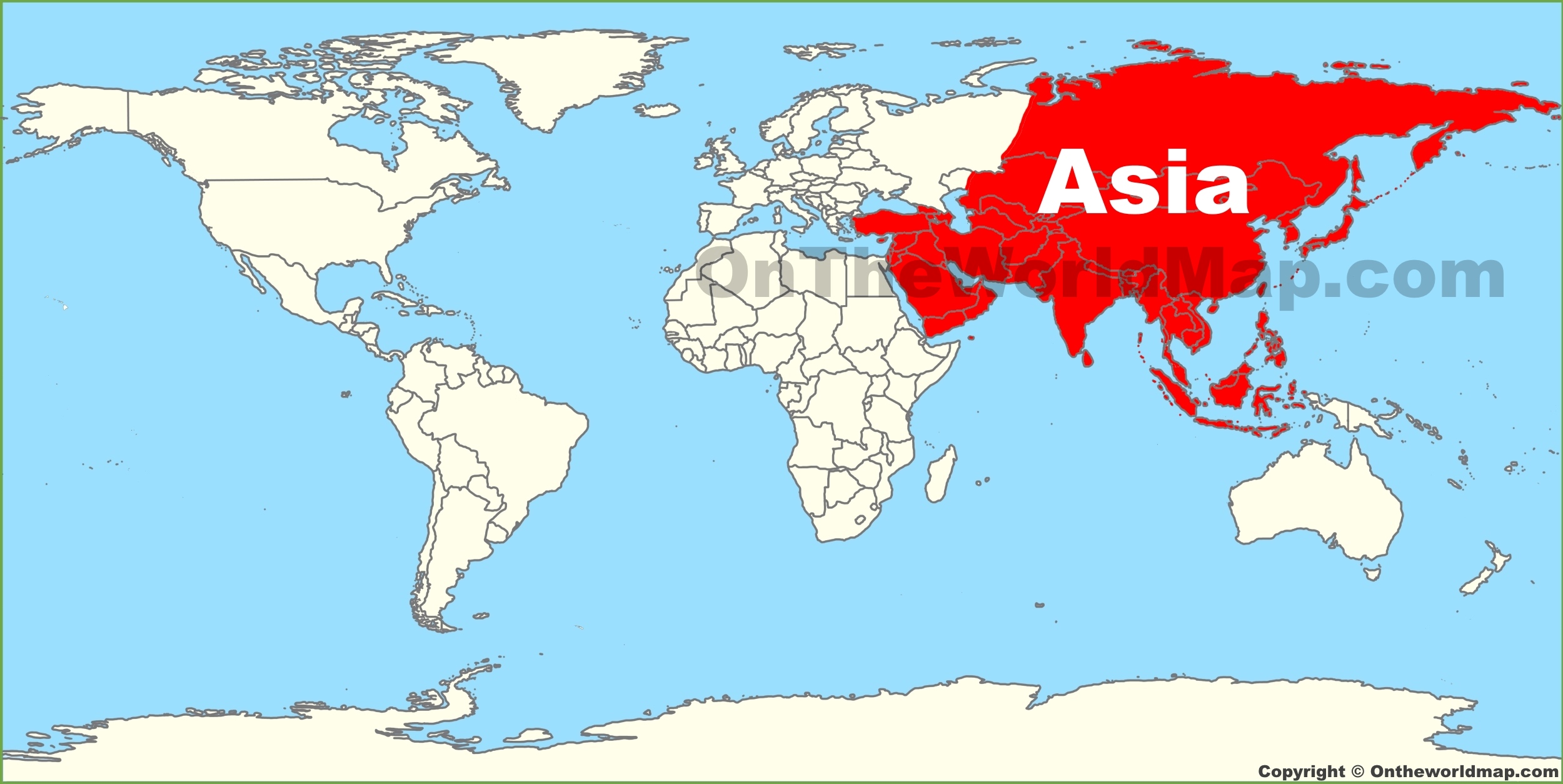
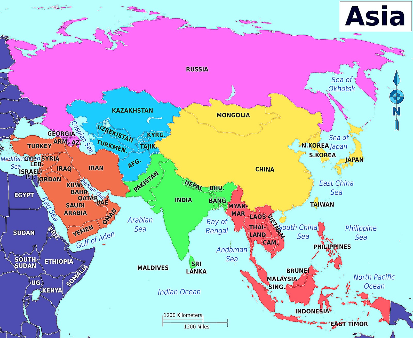
Asia represents the largest and most populous continent on Earth, covering approximately 30% of the world's land area and housing nearly 60% of the global population. Located primarily in the Northern and Eastern Hemispheres, it serves as the foundational hub for international trade, cultural history, and geopolitical strategy. Understanding its precise location requires a blend of physical geography, cartographic conventions, and regional classification systems that define its boundaries across the global sphere.
Defining the Physical Boundaries of Asia
The continent of Asia is defined by its massive expanse, stretching from the Arctic Ocean in the north to the Indian Ocean in the south, and from the Pacific Ocean in the east to the Ural Mountains in the west. Unlike some continents separated by vast oceans, Asia is physically attached to Europe, forming the landmass known as Eurasia.
The Western Boundary: The Ural Connection
The border between Asia and Europe is a subject of historical and geographical consensus. It primarily follows the Ural Mountains in Russia, the Ural River, the Caspian Sea, the Caucasus Mountains, and the Black Sea. This distinction is more cultural and political than strictly tectonic, as the two "continents" sit upon the same continuous crustal plate.
Southern and Eastern Perimeters
To the south, the continent is defined by the Indian subcontinent, which pushes into the Indian Ocean, bordered by the Arabian Sea to the west and the Bay of Bengal to the east. The eastern edge is characterized by an extensive archipelago system, including the islands of Japan, the Philippines, and Indonesia, which bridge the gap toward Oceania.
Cartographic Representation on the Globe
When visualizing Asia on a globe, the sheer scale of the landmass often causes distortion depending on the projection used. On a standard spherical globe, the true size of Asia becomes immediately apparent, dwarfing other continental landmasses.
Managing Global Distortions
Most flat maps utilize the Mercator projection, which tends to exaggerate the size of landmasses near the poles. Because a significant portion of Russia (part of North Asia) lies at high latitudes, maps often make this region appear larger than it is relative to regions like Southeast Asia. A physical globe corrects this visual bias, showing the true proportional relationship between Asian territories and the rest of the world.
The Role of Longitudinal and Latitudinal Lines
Asia spans an incredible range of latitudes, from the tropical climates near the Equator in Indonesia to the polar conditions of the Arctic Circle in Siberia. Longitudinally, it covers 160 degrees of the globe, spanning from the easternmost tip of the Chukchi Peninsula to the westernmost points in Turkey. This immense range is responsible for the diverse climate zones—ranging from arid deserts to lush rainforests—that dictate the agricultural and economic potential of its constituent nations.
Major Geographic Subregions
To effectively categorize the continent for analysis, geographers and international organizations typically divide Asia into five primary regions. Each region occupies a distinct space on the globe and possesses unique environmental and socioeconomic characteristics.
North Asia
Dominated by the Russian Federation, this region encompasses the vast territory of Siberia. It is characterized by permafrost, immense forest reserves, and sparse population density compared to the rest of the continent.
East Asia
This region includes China, Japan, Mongolia, North Korea, South Korea, and Taiwan. It is a critical center for global manufacturing, high-technology production, and some of the world's most densely populated urban centers.
Southeast Asia
Comprising nations such as Vietnam, Thailand, Indonesia, and the Philippines, this region acts as a maritime nexus. It connects the Indian and Pacific Oceans, making it vital for international shipping lanes and global supply chains.
South Asia
Often referred to as the Indian subcontinent, this region includes India, Pakistan, Bangladesh, Nepal, and Sri Lanka. It is defined by the Himalayas to the north and the expansive river basins that support some of the highest population densities on the planet.
West Asia (The Middle East)
Positioned at the intersection of Asia, Africa, and Europe, West Asia is of immense strategic importance due to its energy resources and its role as a historical crossroads for trade and cultural exchange.
Economic and Strategic Importance in 2026
As of 2026, the position of Asia on the globe has cemented its status as the primary engine of global economic growth. The concentration of consumer markets and production capabilities in this region makes it the focus of international trade policy.
| Feature | Description | Strategic Value |
|---|---|---|
| Maritime Chokepoints | Malacca, Hormuz, and Bab el-Mandeb | Controls global energy and goods flow |
| Demographic Weight | Home to 4.7 billion+ people | Largest labor force and consumer base |
| Technological Hubs | Centers in Tokyo, Shenzhen, Seoul | Innovation for global electronics |
| Resource Distribution | Diverse mineral and energy deposits | Foundation for industrial scaling |
Global Supply Chain Integration
The logistical geography of Asia allows for highly integrated supply chains. By utilizing the Pacific maritime routes, manufacturers in East and Southeast Asia can reach global markets with high efficiency. The ongoing development of land-based infrastructure, such as rail links connecting China to Europe, provides additional, albeit slower, alternatives to traditional sea-based shipping.
Environmental Considerations and Global Climate
Asia’s geography places it at the frontline of global climate challenges. The continent’s reliance on monsoon-driven agriculture makes it particularly sensitive to fluctuations in global weather patterns.
- Monsoon Cycles: The predictable shift of winds between the Indian Ocean and the Asian landmass governs the water supply for billions. Disruptions to this cycle have immediate impacts on global grain prices.
- Coastal Vulnerability: With a massive coastline and numerous low-lying island nations, Asia faces significant risks from rising sea levels.
- High-Altitude Glaciation: The "Third Pole" (the Himalayas and Tibetan Plateau) holds the largest reserve of freshwater outside the polar regions. Changes in this region directly impact the water security of nations downstream.
Frequently Asked Questions
Why is the border between Asia and Europe considered artificial?
The boundary is based on historical and cultural conventions rather than tectonic plates. While geographers often cite the Ural Mountains as the division, there is no physical "break" in the landmass, which is why scientists often refer to the entire region as Eurasia.
How does Asia’s size affect its climate diversity?
Because Asia spans from the equator almost to the North Pole, it contains nearly every climate zone. The massive landmass also creates "continental climate" effects, where the interior experiences extreme temperature differences between summer and winter compared to coastal regions.
What is the most important maritime feature in Asian geography?
The Strait of Malacca is widely considered the most critical maritime chokepoint. It is the primary passage between the Indian Ocean and the Pacific Ocean, linking major Asian economies to the Middle East and Europe.
How do time zones work across such a large landmass?
Asia covers 11 different time zones. Due to its extreme longitudinal span, the sun rises and sets at significantly different times across the continent, necessitating complex coordination for cross-continental businesses and governments.
Why is the population density of Asia so much higher than other continents?
The region contains fertile river valleys (such as the Ganges, Yangtze, and Mekong) that have supported intensive agriculture for millennia. This long history of food security allowed for the development of large, stable civilizations that persisted through the centuries.
Recommendation for Further Study
To gain a deeper understanding of Asia's role on the globe, researchers should prioritize examining contemporary geospatial data provided by the United Nations Statistics Division. For those interested in the economic impact, reviewing the annual reports from the Asian Development Bank provides granular insight into how regional geography translates into global trade outcomes. Readers are encouraged to use interactive digital globes, such as those maintained by national geological surveys, to toggle between physical geography and political boundaries, as this illustrates how man-made borders often conflict with natural geographic features.