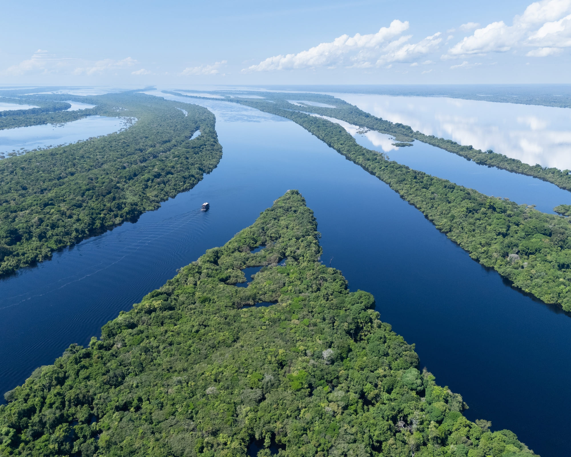
The Amazon River is located in northern South America, flowing east from the Andes Mountains in Peru through Brazil to the Atlantic Ocean. It traverses Peru, forms part of the border with Colombia, and predominantly crosses Brazil. Its basin also encompasses parts of Bolivia, Ecuador, Venezuela, Guyana, and Suriname.
As of 2026, the Amazon River remains the world’s largest river by discharge volume and a central focus of global environmental policy. Determining the exact location of the Amazon involves more than pointing to a spot on a map; it requires understanding a vast drainage system that spans nearly 40% of the South American continent. This article provides a technical and geographical breakdown of where the Amazon River begins, the path it follows, and the nations it defines.
Continental Positioning and Geographic Coordinates
The Amazon River is situated in the northern portion of South America, positioned primarily between the equator and 10 degrees south latitude. Its longitudinal span is immense, stretching from approximately 73° West in the high Andes to roughly 49° West at its mouth on the Atlantic coast.
Geographically, the river acts as a massive drainage artery for the Amazon Basin. This basin is bounded by the Guiana Highlands to the north and the Brazilian Highlands to the south. To the west, the formidable Andes Mountains create a rain shadow and a continental divide, forcing all precipitation that falls on the eastern slopes to flow thousands of miles eastward toward the Atlantic.
The river's path is characterized by a relatively low gradient once it leaves the Andes. For much of its journey through the Brazilian rainforest, the river drops only a few centimeters per kilometer. This topographical feature is why the location of the river is often described as a "river sea," with seasonal floods expanding its width significantly, blurring the lines between permanent riverbanks and temporary floodplains (várzeas).
The Source: Pinpointing the Start in the Andes
Identifying the precise location of the Amazon River's source has been a subject of scientific debate for decades. While the main body of the river is easily identified in Brazil, the "true" source is defined by the most distant point from which water flows into the mouth.
The Traditional Source: Nevado Mismi
For much of the late 20th century, the source was widely accepted as being located on Nevado Mismi, a 5,597-meter (18,363 ft) volcanic peak in the Peruvian Andes. Specifically, the source was identified as a glacial stream on the Carhuasanta slope. This location is in the Arequipa Region of Peru, approximately 160 kilometers west of Lake Titicaca and 700 kilometers southeast of Lima.
The Mantaro River Discovery
In the early 21st century, and reinforced by studies leading up to 2026, researchers utilized satellite tracking and GPS mapping to propose a different source. Research suggests that the Mantaro River in southwestern Peru is actually the most distant source. If the Mantaro is considered the starting point, it adds approximately 47 to 92 kilometers to the river's total length. This source is located in the Junín Region of Peru.
Regardless of which specific peak is designated as the source, the location of the Amazon's headwaters is firmly rooted in the high-altitude, arid environments of the Peruvian Andes, a stark contrast to the humid jungles associated with its downstream reaches.
The Course: From the Andes to the Atlantic
The Amazon River does not actually carry the name "Amazon" for its entire length. Its identity changes based on the country and the confluence of various major tributaries.
The Peruvian Stretch
In Peru, the river begins as a series of small streams that coalesce into the Apurímac, which then joins the Mantaro to become the Ene, then the Tambo, and eventually the Ucayali. Parallel to this, the Marañón River flows from the north. The location where the Ucayali and Marañón rivers meet—near the town of Nauta in Peru—is traditionally where the "Amazon River" proper is said to begin.
The Colombian Corridor
The river then flows northeast toward the "Tres Fronteras" (Triple Frontier), where Peru, Brazil, and Colombia meet. For a short stretch of approximately 1,600 kilometers, the Amazon serves as the international border between Peru and Colombia. The Colombian town of Leticia is the primary hub in this specific location, providing Colombia with its only direct access to the Amazon mainstem.
The Brazilian Solimões
Once the river crosses into Brazil at the border town of Tabatinga, it is known locally as the Rio Solimões. It retains this name for approximately 1,700 kilometers. The location of the Solimões is central to the Brazilian state of Amazonas. It is only after the Solimões meets the Rio Negro at the "Meeting of Waters" near Manaus that Brazilians refer to the river as the Amazonas.
Political Geography: Countries and States
The Amazon River and its basin involve eight sovereign nations and one overseas territory. However, the main stem of the river physically touches only three.
- Peru: Home to the headwaters and the initial formation of the river. The Loreto Region is the primary administrative area for the Peruvian Amazon.
- Colombia: The river forms the southern border of the Amazonas Department, specifically the "Amazon Trapezium" area.
- Brazil: The vast majority of the river's length (approximately 60%) is located within Brazil. It passes through the states of Amazonas and Pará before reaching the sea.
While the river itself does not flow through Bolivia, Ecuador, or Venezuela, these countries are critically located within the drainage basin. Large tributaries like the Madeira (Bolivia), the Napo (Ecuador), and the Casiquiare canal (connecting to the Orinoco in Venezuela) ensure these nations are hydrologically linked to the Amazon's central location.
The Mouth: The Atlantic Gateway
The Amazon River empties into the Atlantic Ocean in northern Brazil. This location is one of the most complex estuarine systems on Earth. Unlike many major rivers, the Amazon does not have a traditional delta that protrudes into the sea. Instead, it has a massive estuary and a submerged delta.
The discharge point is located primarily in the Brazilian state of Pará. The mouth is so wide—roughly 325 kilometers (202 miles)—that it contains Marajó Island, the world’s largest fluvial island (an island formed by river sediments), which is approximately the size of Switzerland.
The force of the water at this location is immense. The Amazon pushes freshwater up to 160 kilometers out into the Atlantic Ocean, diluting the salinity of the sea for thousands of square miles. This specific location is also famous for the pororoca, a tidal bore where Atlantic waves travel up the river for several kilometers, a phenomenon most common near the mouth during the spring tides.
Comparative Geography: The Amazon vs. Other Major Rivers
To understand the scale of the Amazon River's location and volume, it is helpful to compare it to other global giants. While the Nile is often cited as the longest, the Amazon’s location allows it to capture more rainfall than any other system.
| Feature | Amazon River | Nile River | Yangtze River | Mississippi-Missouri |
|---|---|---|---|---|
| Primary Continent | South America | Africa | Asia | North America |
| Length (approx) | 6,400–6,992 km | 6,650 km | 6,300 km | 6,275 km |
| Average Discharge | 209,000 m³/s | 2,830 m³/s | 31,000 m³/s | 16,792 m³/s |
| Basin Area | ~7.0 Million km² | ~3.4 Million km² | ~1.8 Million km² | ~3.2 Million km² |
| Mouth Location | Atlantic (Brazil) | Mediterranean (Egypt) | East China Sea | Gulf of Mexico (USA) |
| Number of Countries | 9 (Basin) | 11 (Basin) | 1 (China) | 2 (USA, Canada) |
Accessing the Amazon: Major Locational Hubs
For those seeking to visit or conduct research at the Amazon River, certain cities serve as the primary gateways to its location. Due to the density of the surrounding rainforest, many of these locations are accessible only by air or water.
Iquitos, Peru
Located in the Loreto Region, Iquitos is the largest city in the world that cannot be reached by road. It sits on the banks of the Amazon in its upper reaches. It serves as the primary location for exploring the Pacaya-Samiria National Reserve and the confluence of the Marañón and Ucayali.
Manaus, Brazil
Manaus is the most significant urban center located on the Amazon (specifically at the confluence of the Rio Negro and Solimões). As a major industrial and tourism hub in the middle of the rainforest, it provides the most infrastructure for accessing the central Brazilian Amazon. It is the site of the famous "Meeting of Waters," where the dark waters of the Rio Negro and the sandy waters of the Solimões flow side-by-side without mixing for several miles.
Belém, Brazil
Belém is located near the mouth of the Amazon River on the Pará River (a distributary). It serves as the gateway to the Atlantic and Marajó Island. It is an essential port for the transport of goods from the interior of the continent to global markets.
Environmental and Technical Significance of the Location
The Amazon River's location is not just a geographical fact; it is a biological necessity. Because the river is located entirely within the tropics, it experiences consistent warmth and high humidity. This creates the "flying rivers" phenomenon—vast quantities of water vapor transpired by the forest and evaporated from the river that are transported by winds across South America, providing essential rainfall to the agricultural regions of southern Brazil, Paraguay, and Argentina.
In 2026, the location of the Amazon's "tipping point" is a major concern for climatologists. This refers to the specific areas within the basin where deforestation might lead to a permanent shift from rainforest to savanna. Most of this risk is located along the "Arc of Deforestation" in the southeastern reaches of the basin in the Brazilian states of Mato Grosso and Pará.
Frequently Asked Questions
Which country has the most of the Amazon River?
Brazil contains approximately 60% of the Amazon River's length and the vast majority of its drainage basin. The river flows through the heart of northern Brazil, and the city of Manaus serves as its central administrative and economic hub. While the river starts in Peru, it reaches its maximum width and volume within Brazilian territory.
Can you drive to the Amazon River?
Access depends on the specific location. You can drive to the edge of the Amazon basin in countries like Ecuador and Colombia (via the Andes), and there are major roads in Brazil like the Trans-Amazonian Highway (BR-230). However, many of the most iconic locations, such as Iquitos in Peru, have no road access and require boat or plane travel. The lack of bridges over the main stem of the Amazon—due to its extreme width and seasonal flooding—makes continuous road travel across the river impossible in most areas.
What is the exact coordinate of the Amazon River's mouth?
The mouth of the Amazon River is located at approximately 0°10′S 49°00′W. This puts the discharge point almost exactly on the equator. Because the mouth is an estuary system spanning hundreds of kilometers, this coordinate represents the central flow path near Marajó Island as it enters the Atlantic Ocean.
Does the Amazon River flow through the rainforest?
Yes, the Amazon River is the primary hydrological feature of the Amazon Rainforest, the world's largest tropical rainforest. The river and the forest are part of a reciprocal ecosystem; the forest depends on the river's water, while the river's volume is maintained by the high levels of precipitation generated by the forest's transpiration.
Why is the Amazon River's location important for the world?
The Amazon River's location is vital because it accounts for 20% of the total river water entering the world's oceans. This massive influx of freshwater affects ocean currents and marine ecosystems in the Atlantic. Furthermore, the location of the surrounding basin acts as a global carbon sink, playing a critical role in mitigating climate change.
Recommendation for Further Exploration
To truly understand the Amazon River location, one should utilize high-resolution satellite imagery or GIS (Geographic Information System) tools. If you are planning a physical visit, focus on the "Triple Frontier" area (Leticia, Colombia; Tabatinga, Brazil; and Santa Rosa de Yavari, Peru) to witness how the river facilitates international transit and cultural exchange in one of the most remote regions on Earth. For scientific study, the Meeting of Waters in Manaus remains the premier location for observing the hydrological complexity of the river's diverse tributaries.