A continental shelf is the shallow, submerged edge of a continent that extends from the shoreline to a point where the seafloor drops off sharply into the deep ocean. Geologically, it is part of the continental crust, meaning it is technically land that happens to be covered by relatively shallow seawater.
The continental shelf represents one of the most vital regions of our planet. Although it covers only about 7% to 8% of the total ocean area, it is home to the vast majority of marine life and provides the bulk of the world's seafood and subsea energy resources. To understand the continental shelf is to understand the bridge between the terrestrial world we inhabit and the mysterious "abyss" of the deep ocean.
The Geological Structure of the Continental Shelf
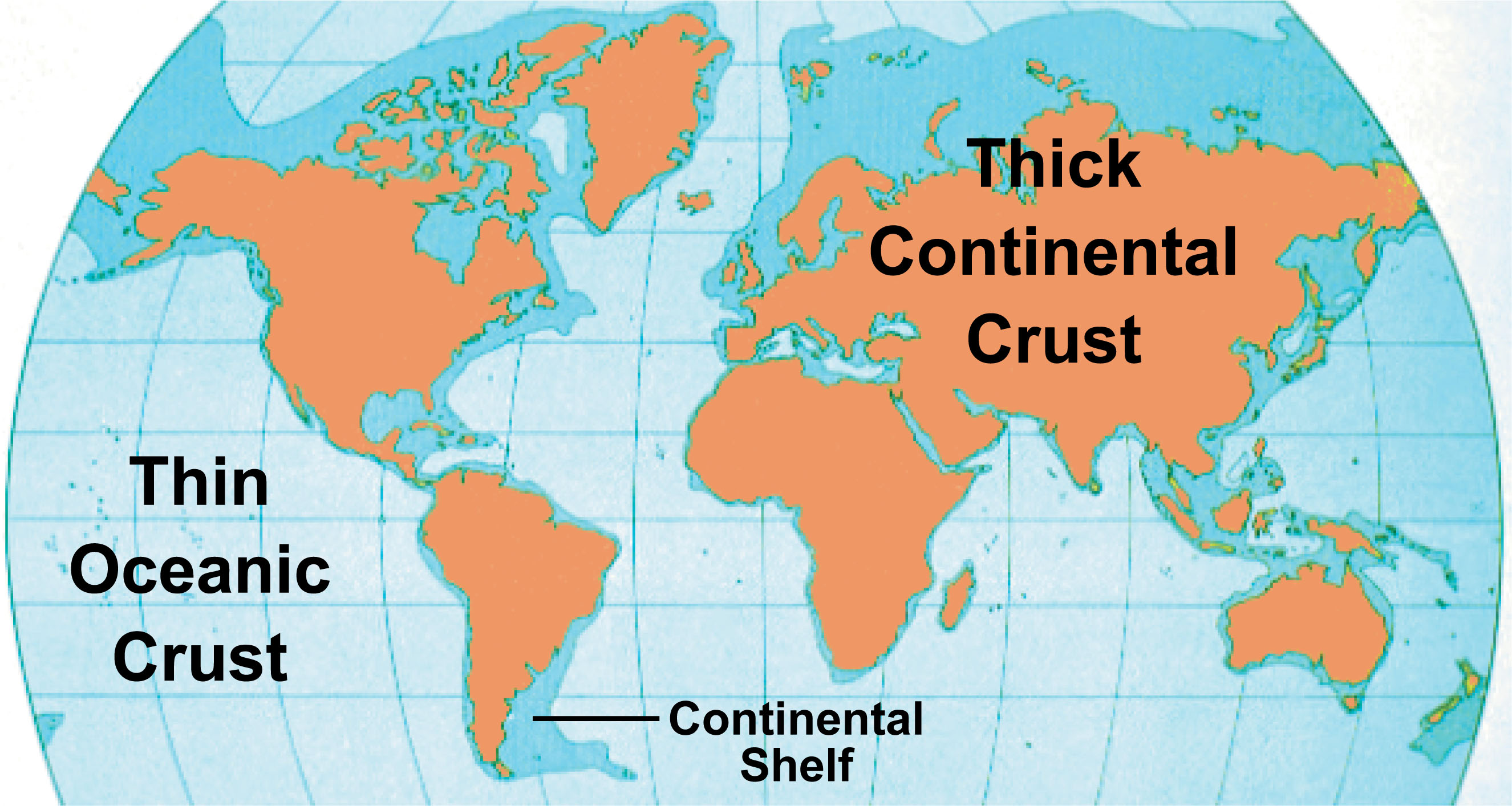
To grasp a simple definition of a continental shelf, one must first look at the composition of the Earth's crust. Our planet features two primary types of crust: oceanic crust, which is thin and dense (primarily basalt), and continental crust, which is thicker and more buoyant (primarily granite). The continental shelf is the portion of that buoyant granitic crust that currently sits below sea level.
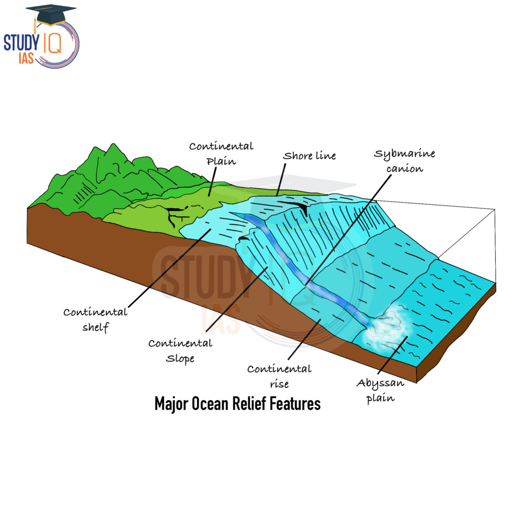
The shelf begins at the low-water mark (the shoreline) and continues outward with a very gentle slope. On average, the shelf descends at an angle of only about 0.1 degrees—a slope so slight that it would appear perfectly flat to the human eye if the water were removed. This gentle incline continues until it reaches the shelf break, the point where the gradient increases significantly, leading down into the continental slope.
The Shelf Break: The True Boundary
The shelf break is the definitive "edge" of the continental shelf. At this point, the seafloor typically sits at a depth of approximately 140 to 200 meters (460 to 650 feet). Beyond this break, the angle of the descent increases from 0.1 degrees to 3 or 4 degrees, marking the transition to the continental slope. While 4 degrees might still sound small, in geological terms, it represents a massive drop-off toward the ocean floor.
Global Variations in Width
The width of a continental shelf is not uniform. It is dictated by tectonic activity and coastal geography. For example:
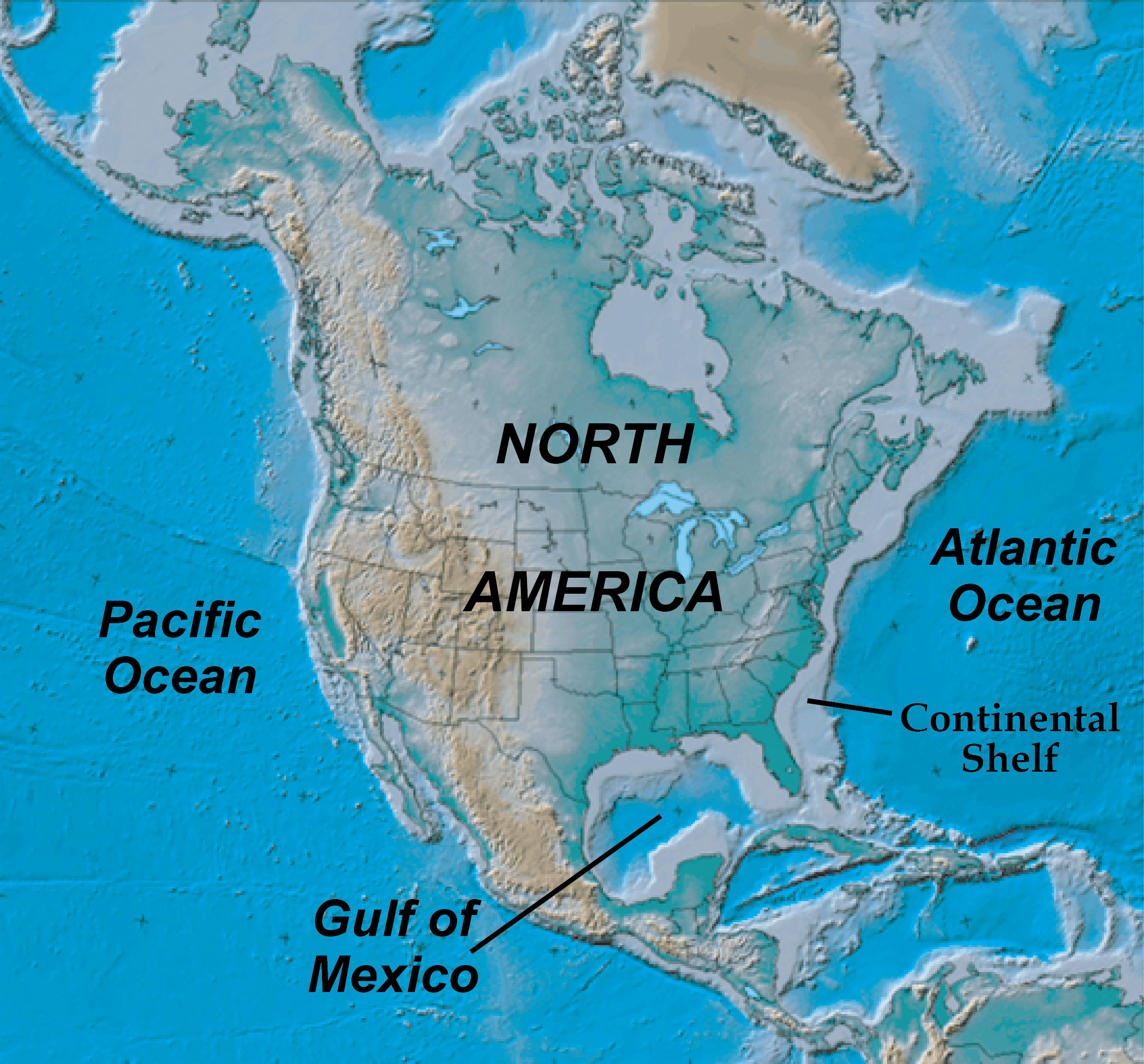
- Active Margins: Along the western coast of the Americas, where tectonic plates are colliding, the continental shelf is extremely narrow, sometimes virtually non-existent.
- Passive Margins: Along the Atlantic coast of North America and Europe, where there is no nearby plate boundary, the shelf is broad and expansive.
- The Siberian Shelf: Located in the Arctic Ocean, this is the widest continental shelf in the world, stretching roughly 1,500 kilometers (930 miles) from the coastline.
How Continental Shelves Are Formed
Continental shelves are dynamic features that have been shaped over millions of years by two primary forces: the movement of tectonic plates and the fluctuating levels of the world’s oceans.
The Impact of Sea Level Fluctuations
The current state of our continental shelves is heavily influenced by the most recent Ice Ages. During periods of heavy glaciation, vast amounts of the Earth's water were frozen in ice sheets. This caused global sea levels to drop by as much as 120 meters (400 feet). During these times, much of what we now call the continental shelf was dry land.
Archaeological evidence shows that prehistoric humans walked across these "land bridges." For instance, Doggerland was a massive area of dry land connecting Great Britain to mainland Europe during the last glacial period. As the ice melted and sea levels rose, these areas were flooded, creating the shallow seas we see today.
Sediment Deposition
Shelves are also built up through the process of sedimentation. Over eons, rivers carry silt, sand, and organic debris from the heart of the continents into the sea. This material settles along the coast, gradually extending the shelf outward. In regions with massive river systems like the Amazon or the Mississippi, these sediment layers can be several kilometers thick, acting as a geological record of the continent's history.
The Biological and Ecological Importance
If the open ocean is a desert, the continental shelf is a rainforest. Despite its small geographic footprint, the shelf environment is the most productive part of the marine ecosystem.
The Photic Zone and Primary Productivity
Because the water on the continental shelf is relatively shallow, sunlight can often penetrate all the way to the seafloor. This region is known as the photic zone. Sunlight allows for the growth of phytoplankton—microscopic organisms that form the base of the entire marine food web.
Through photosynthesis, these organisms convert sunlight and nutrients (often supplied by river runoff or deep-sea upwelling) into energy. This abundance of food attracts zooplankton, which in turn attract small fish, leading up to apex predators like sharks and whales.
Diverse Marine Habitats
The continental shelf supports several distinct and critical ecosystems:
- Coral Reefs: Found in warm, shallow shelf waters, these "cities of the sea" support a quarter of all marine species.
- Kelp Forests: In cooler waters, giant kelp grows from the shelf floor to the surface, providing shelter for thousands of species.
- Seagrass Meadows: These areas act as massive carbon sinks and nurseries for juvenile fish.
Economic and Strategic Significance in 2026
In 2026, the continental shelf remains a focal point for global economic stability and energy security. Its proximity to land and shallow depth make it accessible for industrial activities that are impossible in the deep "abyssal" zones.
Fisheries and Food Security
Approximately 90% of the world's fish catch is harvested from the waters above continental shelves. The concentration of nutrients and sunlight makes these areas the primary breeding grounds for commercially vital species like cod, tuna, mackerel, and shellfish. Maintaining the health of the shelf is therefore directly linked to global food supplies.
Energy Resources: Traditional and Renewable
The sedimentary rocks beneath the continental shelf contain the vast majority of the world's offshore oil and natural gas reserves. Since the mid-20th century, technology has allowed us to tap into these reserves using offshore drilling platforms.
However, as of 2026, the focus has shifted significantly toward offshore wind energy. Because the shelf provides a stable, relatively shallow floor, it is the ideal location for anchoring massive wind turbines. These "wind farms" take advantage of the unobstructed winds found at sea to generate clean electricity for coastal cities.
Mineral Wealth
Beyond energy, the shelf is a source of minerals. Sand and gravel are frequently mined from the shelf for use in construction and land reclamation projects. Additionally, "placer deposits"—concentrations of heavy minerals like gold, diamonds, and tin—are often found in the ancient riverbeds that were submerged as sea levels rose.
Legal and Political Boundaries: UNCLOS
The definition of the continental shelf isn't just a matter of science; it is a matter of international law. The United Nations Convention on the Law of the Sea (UNCLOS) provides the legal framework for how nations claim and manage these areas.
The Exclusive Economic Zone (EEZ)
Under UNCLOS, coastal nations generally have sovereign rights over the resources of the sea and the seabed within 200 nautical miles (370 kilometers) of their coast. This area is known as the Exclusive Economic Zone. In most cases, the physical continental shelf fits within this boundary.
The Extended Continental Shelf (ECS)
In some regions, the physical continental shelf extends far beyond the 200-mile limit. In these instances, a nation can submit a claim to the Commission on the Limits of the Continental Shelf (CLCS) to extend their rights over the seafloor (but not the water above it) up to 350 nautical miles from the shore.
In 2026, these claims are particularly contentious in the Arctic, where nations like Russia, Canada, and Denmark are vying for control over the submerged Lomonosov Ridge, which could hold vast untapped resources.
Comparing Oceanic Zones
To better visualize where the continental shelf fits, it is helpful to compare it to the other components of the "continental margin."
| Feature | Average Depth | Gradient (Slope) | Primary Composition |
|---|---|---|---|
| Continental Shelf | 0 – 200 meters | ~0.1° (Very Flat) | Continental crust, thick sediment |
| Continental Slope | 200 – 3,000 meters | 3° – 6° (Steep) | Transitional crust, canyons |
| Continental Rise | 3,000 – 4,000 meters | 0.5° – 1° (Gentle) | Massive piles of sediment (fans) |
| Abyssal Plain | 4,000 – 6,000 meters | < 0.05° (Flat) | Oceanic crust (basalt), fine clay |
Environmental Challenges Facing the Shelf in 2026
Despite its resilience, the continental shelf faces unprecedented pressure in the mid-2020s. Human activity has moved from the shoreline into the deeper parts of the shelf, leading to several critical issues.
- Ocean Acidification: As the oceans absorb more CO2, the water becomes more acidic. This is particularly devastating on the continental shelf, where calcifying organisms like corals and shellfish struggle to build their skeletons.
- Bottom Trawling: This fishing method involves dragging heavy nets across the seafloor. On the continental shelf, this can destroy delicate habitats like sponge gardens and cold-water corals that have taken centuries to grow.
- Runoff and Dead Zones: Because the shelf is adjacent to land, it receives all the chemical runoff from agriculture. Excessive nitrogen and phosphorus lead to algae blooms that deplete oxygen, creating "dead zones" where no fish can survive.
FAQ: Common Questions About Continental Shelves
What is the simplest definition of a continental shelf?
It is the edge of a continent that lies under relatively shallow ocean water. Think of it as the "shoulder" of the continent before the seafloor drops off into the deep ocean.
Can you walk on a continental shelf?
Currently, no, because it is covered by water. However, during the Ice Ages, sea levels were lower, and much of the continental shelf was dry land where humans and animals lived. Today, you would need scuba gear or a submarine, as the shelf is covered by up to 200 meters of water.
Why is the continental shelf important for the economy?
It is the source of nearly all offshore oil and gas, it provides 90% of the world's commercial fish catch, and it is the primary location for the rapidly growing offshore wind energy industry.
Is the continental shelf part of the ocean floor?
Yes and no. While it is the "floor" of the shallow sea, geologically it is made of continental crust (granite), whereas the true deep ocean floor is made of oceanic crust (basalt).
How far does the continental shelf extend?
It varies wildly. In some places, like the coast of Chile, it is almost non-existent. In other places, like the Siberian Shelf in the Arctic, it extends 1,500 kilometers (over 900 miles) from the shore.
What is the difference between the shelf and the slope?
The shelf is the flat, shallow part near the land. The slope is the steep "cliff" that leads from the edge of the shelf down to the deep ocean floor.
Practical Recommendation for Further Exploration
For those interested in the geographic specifics of their local coastline, the National Oceanic and Atmospheric Administration (NOAA) and the General Bathymetric Chart of the Oceans (GEBCO) offer interactive digital maps. By 2026, high-resolution seafloor mapping (Seabed 2030 initiative) has made it possible to view the intricate canyons and ridges of the continental shelf in unprecedented detail. Exploring these maps provides a clear visual understanding of how the land we stand on continues beneath the waves, forming the vital submerged margins of our world.