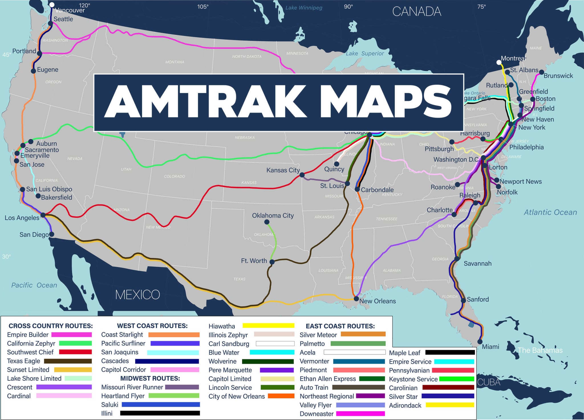
The Amtrak California Zephyr follows a 2,438-mile route between Chicago and Emeryville (San Francisco), traversing the heart of the Rocky Mountains and the Sierra Nevada. As one of North America's most scenic rail journeys, the map includes key stops in Omaha, Denver, Salt Lake City, and Reno, with the full transcontinental crossing taking approximately 51 hours.
Understanding the California Zephyr map is essential for anyone planning a journey across the American West. This legendary route, often referred to as the "Silver Lady," does not merely transport passengers from point A to point B; it serves as a moving observatory through some of the most inaccessible and breathtaking landscapes in the United States. In 2026, the route continues to be a flagship of the Amtrak long-distance network, utilizing bi-level Superliner equipment to provide panoramic views of the continental divide, red rock canyons, and high-altitude mountain passes.
The Geography of the California Zephyr Route
The California Zephyr (Trains 5 and 6) operates daily, tracing a path that mirrors much of the first transcontinental railroad. The journey begins or ends at Chicago Union Station, a massive transit hub that connects the Midwest to the rest of the nation. From Chicago, the tracks head west across the rolling prairies of Illinois and Iowa, crossing the Mississippi River at Burlington.
As the train moves into Nebraska, the landscape flattens into the Great Plains. This section is characterized by vast agricultural vistas and historic telegraph lines that follow the right-of-way. While this portion of the map is often viewed as a prelude to the mountains, it offers a distinct sense of the scale of the American heartland. The tracks roughly parallel the Platte River, a historical corridor for the Oregon Trail and the Pony Express.
The real dramatic shift in the geography occurs in Denver, Colorado. Known as the "Mile High City," Denver is the gateway to the Rockies. From here, the train begins a grueling ascent, climbing nearly 4,000 feet in just a few hours. This is where the map becomes intricate, as the tracks must navigate the "Big Ten Curve" and 28 tunnels before reaching the Moffat Tunnel, which pierces the Continental Divide at an elevation of over 9,200 feet.
Major Stations and Critical Stops
While the California Zephyr stops at over 30 stations, several serve as major anchors for travelers. Each of these stops provides a different logistical function, from major metropolitan connections to scenic gateway towns.
Chicago Union Station (Illinois)
As the eastern terminus, Chicago Union Station is the starting point for Westbound Train 5. Passengers often arrive here via the Lake Shore Limited or the Capitol Limited from the East Coast. The station features the Metropolitan Lounge for sleeper car passengers, offering a refined space to wait before boarding.
Denver Union Station (Colorado)
Denver is a pivotal point on the map. Westbound, the train arrives in the early morning, allowing passengers to witness the climb into the Rockies in full daylight. The station itself is a restored historic landmark, integrated into a vibrant downtown district with easy access to local light rail and bus services.
Glenwood Springs (Colorado)
Located in the heart of the Rockies, Glenwood Springs is a popular "get-off" point for tourists. The station is within walking distance of the world-famous Glenwood Hot Springs Pool and the Hotel Colorado. The segment between Denver and Glenwood Springs is widely considered the most scenic portion of the entire Amtrak system.
Salt Lake City (Utah)
Salt Lake City serves as a major middle-point. For both eastbound and westbound travelers, this stop typically occurs late at night or in the very early morning hours. Despite the timing, it is a crucial hub for those traveling to Utah’s "Mighty 5" National Parks via rental cars or regional connections.
Reno (Nevada)
"The Biggest Little City in the World" provides a stark contrast to the wilderness of the previous day's travel. The Reno station is located in a below-grade trench in the center of the city, placing passengers directly amidst the casinos and downtown life.
Emeryville and San Francisco (California)
The western terminus of the rail line is Emeryville. Because there are no heavy rail passenger tracks across the Bay Bridge, Amtrak provides a dedicated Thruway Bus connection from Emeryville directly into various points in San Francisco, including Salesforce Transit Center.
Navigating Scenic Landmarks by Segment
When examining the California Zephyr map, the route is best understood through its distinct scenic segments. Each geographic region offers unique geological and historical landmarks that are often only visible by train.
| Route Segment | Key Landmarks | Primary Geographic Feature |
|---|---|---|
| Chicago to Omaha | Mississippi River Bridge, Iowa Farmlands | Midwestern Prairies |
| Omaha to Denver | Platte River Valley, Eastern Colorado Plains | Great Plains |
| Denver to Glenwood Springs | Moffat Tunnel, Gore Canyon, Colorado River | Rocky Mountains |
| Glenwood Springs to Grand Junction | Ruby Canyon, Red Rock Formations | Colorado River Canyons |
| Salt Lake City to Reno | Great Salt Lake Desert, Humboldt River | Great Basin Desert |
| Reno to Sacramento | Donner Pass, Truckee River, Sierra Nevada | Sierra Nevada Mountains |
| Sacramento to Emeryville | San Pablo Bay, Carquinez Strait | California Coast/Bay Area |
The Moffat Tunnel and Gore Canyon
West of Denver, the train enters the Moffat Tunnel, a 6.2-mile engineering marvel completed in 1928. After emerging on the western side of the divide, the train follows the headwaters of the Colorado River. The tracks enter Gore Canyon, a narrow, steep-walled chasm where no roads exist. This segment is exclusive to rail passengers and rafters, offering views of sheer granite walls and class V rapids.
Ruby Canyon
On the border between Colorado and Utah lies Ruby Canyon. This area is famous for its brilliant red sandstone cliffs. Because there is no road access into Ruby Canyon, the California Zephyr is the only way to see this specific desert landscape from the land. Look for the "Utah/Colorado" state line painted on the canyon walls by railroad workers.
Donner Pass
Named after the ill-fated Donner Party, this pass in the Sierra Nevada mountains represents the final major climb of the journey. The map here shows the tracks winding around Donner Lake, through high-altitude granite peaks and snow sheds designed to keep the tracks clear during massive winter storms. This segment offers a masterclass in railroad engineering and American history.
On-Board Equipment and Viewing Facilities
To fully appreciate the route depicted on the map, Amtrak utilizes Superliner cars. These bi-level railcars are taller than standard single-level trains, providing a higher vantage point for viewing the landscape.
- The Sightseer Lounge: This is the heart of the California Zephyr. Located in the middle of the train, it features floor-to-ceiling windows and outward-facing seats. In 2026, these cars remain the primary social hub where National Park Service volunteers (through the Trails on Rails program) occasionally provide seasonal commentary on the geography and history passing by.
- Sleeping Accommodations: For a two-night journey, many travelers opt for Roomettes or Bedrooms. These are located on the upper and lower levels of the Sleeping Cars. Upper-level rooms generally offer better views of the canyons, while lower-level rooms provide a smoother, quieter ride with less swaying.
- Dining Car: Traditional Dining is available for sleeper car passengers, featuring chef-prepared meals. The Dining Car windows are large, ensuring that even during breakfast or dinner, you do not miss the landmarks indicated on your map.
Practical Logistics for Planning Your Trip
Planning a trip on the California Zephyr requires more than just looking at a map; it requires an understanding of timing and seasonal variations.
Direction of Travel
Choosing between Eastbound (Train 6) and Westbound (Train 5) can impact what you see. Historically, the Westbound train is preferred for seeing the Rockies in the morning light and the Sierra Nevadas the following afternoon. However, the Eastbound train offers a spectacular sunset descent into the Great Basin and a full day in the Rockies heading toward Denver.
Booking in 2026
As of 2026, Amtrak uses a dynamic pricing model similar to airlines. Booking several months in advance is recommended, especially for private sleeping rooms, which often sell out during the peak summer and autumn foliage seasons. The California Zephyr remains a high-demand route for international tourists and domestic rail enthusiasts alike.
Cell Service and Connectivity
It is important to note that the map of the California Zephyr passes through some of the most remote "dead zones" in the United States. While Amtrak offers Wi-Fi on many routes, the signal is often non-existent in the depths of Gore Canyon or the middle of the Nevada desert. Travelers should download digital maps, music, and reading material for offline use before departing.
Common Challenges and Troubleshooting
Rail travel of this distance can face operational challenges. Understanding these can help manage expectations.
- Freight Interference: The tracks are primarily owned by freight railroads (Union Pacific and BNSF). This can occasionally lead to "siding" delays where the passenger train must wait for freight traffic to pass.
- Weather Delays: The route crosses two major mountain ranges. Heavy snow in the Sierras or Rockies can lead to slow orders or, in rare cases, service disruptions. Always check the Amtrak app for real-time status updates based on the train's current position on the map.
- Connectivity: As mentioned, do not rely on the train's Wi-Fi for work-critical tasks. The journey is designed for "unplugging."
FAQ: California Zephyr Map and Route
What is the best time of year to ride the California Zephyr?
The "best" time depends on your visual preference. For snow-capped peaks and winter wonderlands, January through March is ideal. For lush greenery and the longest daylight hours (to see the most of the map), June and July are preferred. September and October offer spectacular golden aspens in the Colorado Rockies.
Can you see the Golden Gate Bridge from the train?
No, the train terminates in Emeryville. To see the Golden Gate Bridge, you must take the Thruway Bus or a ride-share into San Francisco. The train does, however, provide beautiful views of the San Pablo Bay and the Carquinez Strait just before arriving in Emeryville.
Is food included in the ticket price?
For passengers in Sleeping Car accommodations (Roomettes and Bedrooms), all meals in the Dining Car are included. Coach passengers can purchase snacks, light meals, and beverages in the Cafe Car, which is located on the lower level of the Sightseer Lounge.
How long are the stops at the major stations?
Most stops are only a few minutes long—just enough time for passengers to board or detrain. However, "fresh air stops" like Denver, Grand Junction, Salt Lake City, and Reno usually last 15 to 30 minutes, allowing passengers to step onto the platform. Always stay close to the train, as the "All Aboard" signal can happen quickly.
Does the train go through the Grand Canyon?
No. While the California Zephyr travels through many canyons (Gore, Glenwood, Byers, Ruby, and Echo), it does not go through the Grand Canyon. To see the Grand Canyon by rail, you would need to take the Southwest Chief to Williams, Arizona, and connect to the Grand Canyon Railway.
Recommendation for Travelers
For the best experience, start your journey in Chicago and head Westbound. Ensure you have a seat in the Sightseer Lounge by the time the train departs Denver (usually around 8:00 AM). This guarantees you a front-row seat for the climb into the Moffat Tunnel and the subsequent descent into the Colorado River canyons. If your budget allows, booking a Roomeette for at least the Denver-to-Emeryville portion of the map will provide the privacy and comfort needed to enjoy the 51-hour transit across the American West.