Latitude, longitude, and altitude form the three-dimensional coordinate system used to pinpoint any specific location on or above the Earth's surface. Latitude and longitude provide a horizontal position by defining north-south and east-west coordinates, while altitude specifies the vertical distance above a reference point, typically sea level, completing the precise location profile.
The Foundation of Horizontal Positioning: Latitude and Longitude
To represent positions on a sphere like the Earth, we rely on a geographic coordinate system. This system is essentially a grid wrapped around the planet, allowing for the universal identification of any location without needing local landmarks or street names.
Understanding Latitude: The North-South Axis
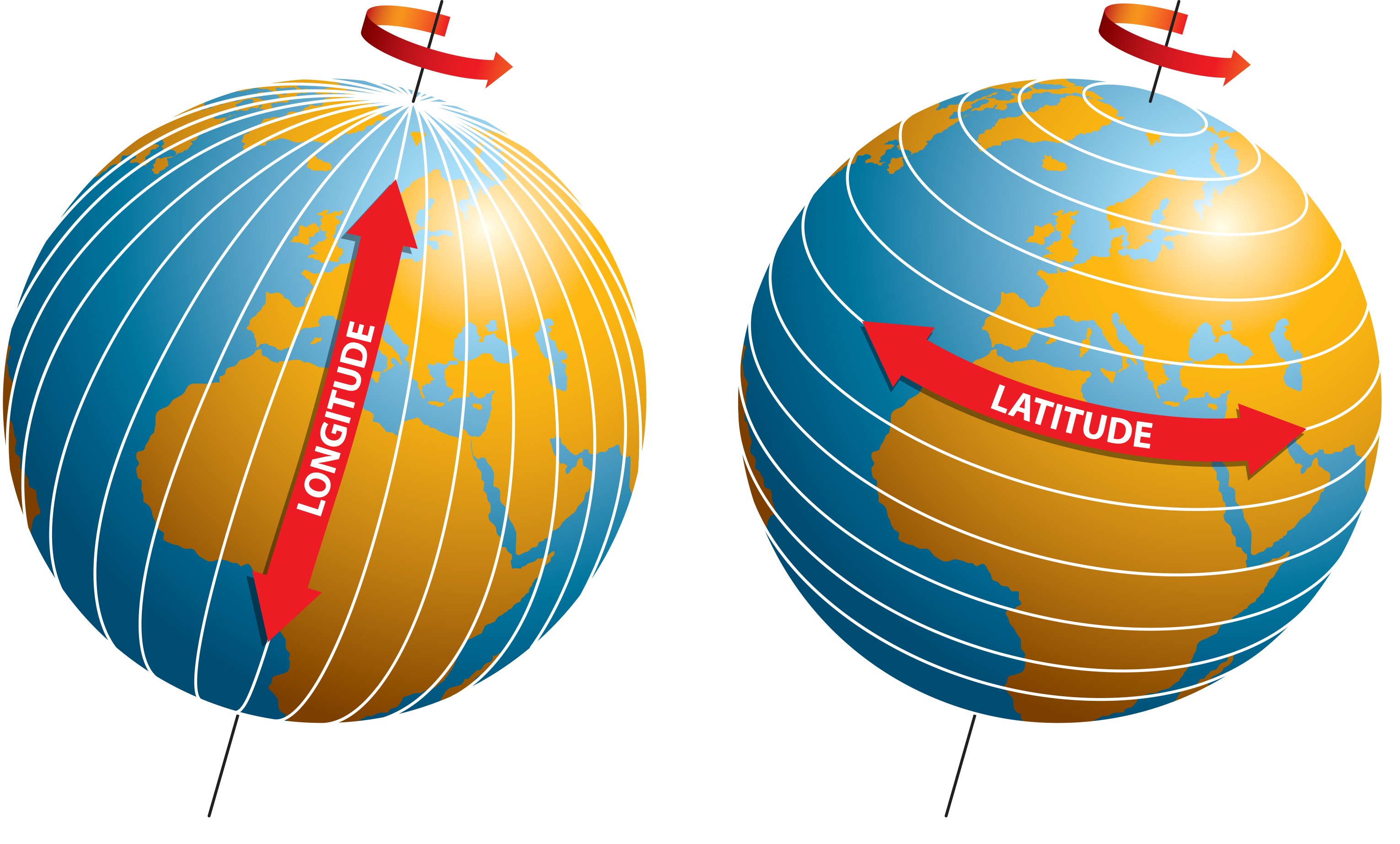
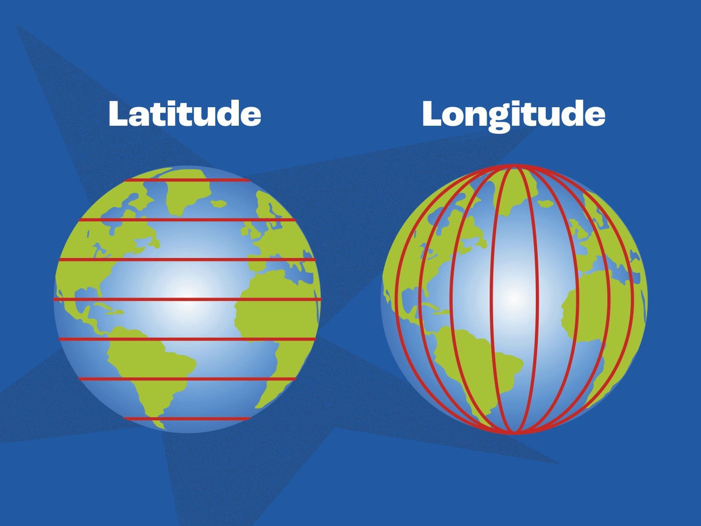
Latitude describes how far north or south a point is from the Equator. These lines, also known as parallels, run horizontally around the globe, parallel to the Equator.
- The Equator: Defined as 0° latitude, the Equator bisects the Earth into the Northern and Southern Hemispheres.
- Measurement: Latitude is measured in degrees, minutes, and seconds, ranging from 0° at the Equator to 90° North at the North Pole and 90° South at the South Pole.
- Function: Because these lines are parallel, they provide a consistent measurement of distance from the center-most point of the Earth. One degree of latitude is approximately 111 kilometers (about 69 miles).
Understanding Longitude: The East-West Axis
Longitude describes how far east or west a point is from the Prime Meridian. Unlike latitude lines, which are parallel, lines of longitude—known as meridians—converge at the poles.
- The Prime Meridian: Established as 0° longitude, this line runs through the Royal Observatory in Greenwich, London.
- Measurement: Longitude ranges from 0° to 180° East and 0° to 180° West. The 180° meridian is essentially the International Date Line.
- Function: Because the Earth is a sphere, the distance between meridians shrinks as you move from the Equator toward the poles. At the Equator, one degree of longitude is roughly 111 kilometers, but this distance decreases to zero at the North and South Poles.
Adding the Third Dimension: Understanding Altitude
While latitude and longitude provide your location on a two-dimensional map, they do not tell you if you are at the bottom of a canyon or at the peak of a mountain. For this, we use altitude.
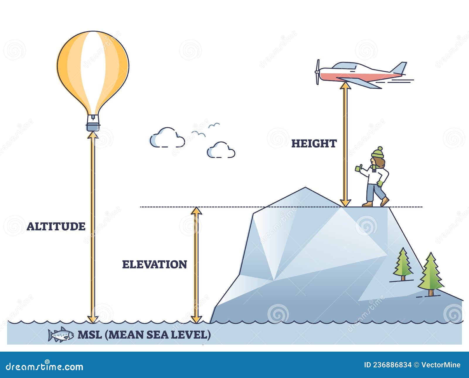
Altitude is the height of an object or point in relation to a fixed reference plane, most commonly mean sea level (MSL). In aviation, meteorology, and geography, altitude is critical because environmental conditions change drastically as one moves vertically.
- Mean Sea Level (MSL): This is the average level of the surface of one or more of Earth's oceans from which heights such as elevation may be measured.
- Elevation vs. Altitude: While often used interchangeably in casual conversation, in technical terms, elevation refers to the height of a land point above sea level, while altitude often refers to the height of an object (like an aircraft) above the ground or sea level.
- Why it Matters: Air pressure, temperature, and oxygen levels are all functions of altitude. For instance, as altitude increases, atmospheric pressure drops, which is why commercial aircraft must pressurize their cabins to ensure passenger safety and comfort.
Comparison of Coordinate Measurements
To effectively use these metrics, it is helpful to understand how they differ in their measurement standards and applications.
| Coordinate Type | Measures | Primary Reference | Units Used |
|---|---|---|---|
| Latitude | North-South position | Equator (0°) | Degrees, Minutes, Seconds |
| Longitude | East-West position | Prime Meridian (0°) | Degrees, Minutes, Seconds |
| Altitude | Vertical position | Mean Sea Level (MSL) | Meters or Feet |
Navigating Systems and Accuracy
In 2026, the reliance on Global Navigation Satellite Systems (GNSS), such as the United States' GPS, the European Union's Galileo, and others, has made finding these coordinates trivial for the average user. However, understanding the underlying technology is important for ensuring accuracy.
How Receivers Calculate Location
Your smartphone or a handheld GPS device does not simply "guess" where you are. It receives timing signals from multiple satellites orbiting the Earth. By calculating the time it takes for a signal to travel from several different satellites to the receiver, the device can mathematically determine your exact latitude and longitude.
Altitude is generally more difficult for standard consumer devices to calculate accurately compared to horizontal position. GPS satellites calculate distance based on the geometry of the sphere, and early consumer-grade hardware often struggles with vertical precision, leading to "altitude drift," where your reading might fluctuate by several meters even if you are standing still.
Common Sources of Error
- Atmospheric Interference: Signals must pass through the ionosphere and troposphere. Changes in water vapor content or solar activity can delay these signals, introducing errors.
- Multipath Error: In urban environments, signals bounce off tall buildings before reaching your device. This adds extra travel time to the signal, which the device interprets as a change in distance, leading to an incorrect location fix.
- Reference Frames: Because the Earth is not a perfect sphere—it is an oblate spheroid—different mapping systems (datums) use slightly different mathematical models of the Earth. If your map and your GPS receiver are using different datums (e.g., WGS84 vs. NAD83), your coordinates may appear "shifted" by several meters.
Practical Applications of Coordinate Data
Understanding these three metrics is vital across numerous professional and personal fields.
- Aviation and Maritime Navigation: Pilots and captains use a combination of latitude, longitude, and altitude (or flight levels) to maintain separation from other vehicles and terrain. Modern flight management systems integrate these three values to optimize fuel consumption and maintain strict arrival windows.
- Surveying and Construction: Civil engineers must account for elevation (altitude) when designing drainage systems, roads, and skyscrapers. A building designed without accurate altitude data relative to the local water table can face catastrophic structural failure.
- Scientific Research: Ecologists tracking animal migration or climate scientists measuring ice sheet thickness rely on high-precision coordinate data to ensure that their observations are repeatable and comparable across years of study.
- Geocaching and Recreation: Outdoor enthusiasts use handheld GPS units to navigate remote terrain. In these instances, knowing one's altitude can be a safety feature, helping hikers gauge how much ascent is remaining for a trek or providing an early warning of rapid weather changes that occur at higher altitudes.
Frequently Asked Questions
Does altitude affect my latitude and longitude readings? Technically, no. Latitude and longitude are angular measurements based on the Earth’s surface projection. However, if you are using a GPS device, extreme altitude can affect signal quality by changing your line-of-sight to the satellites.
Why is my GPS altitude reading sometimes negative? If you are near the coast or in an area with a low-lying basin, your GPS device may show a negative altitude. This occurs because the device’s "zero" point is a mathematical model of sea level. In some inland regions, the local ground elevation is actually lower than the theoretical mean sea level defined by the coordinate datum.
Are degrees, minutes, and seconds the only way to express coordinates? No. While the traditional "Degrees, Minutes, Seconds" (DMS) format is common, modern digital systems often use "Decimal Degrees" (DD). For example, 45° 30' N might be expressed as 45.5000°. Decimal degrees are preferred for computer processing because they are easier to store and calculate.
How do I find my current coordinates? Most modern smartphones have built-in compass or map applications that display your latitude and longitude. For altitude, you may need to download a dedicated "altimeter" app, which uses a combination of GPS data and the device's internal barometric pressure sensor for improved accuracy.
What is the most accurate way to measure altitude? Professional surveying uses differential GPS (DGPS) or RTK (Real-Time Kinematic) technology, which compares signals from a base station with known coordinates to your mobile receiver. For hobbyists, a barometric altimeter—which measures pressure changes—is often more consistent than raw GPS altitude readings, provided it is calibrated to a known point.
Next Steps for Precise Positioning
If your work or hobby requires high-level precision, the first step is to ensure your software settings are aligned to the correct Geodetic Datum. For most global applications, WGS84 (World Geodetic System 1984) is the universal standard.
When you need to perform a task requiring exact coordinates, verify that your device has achieved a "lock" on at least four satellites to ensure a stable three-dimensional fix. If you are in a high-density area or deep canyon, minimize environmental interference by moving to an open space to verify your initial coordinates before proceeding with your navigation or survey.