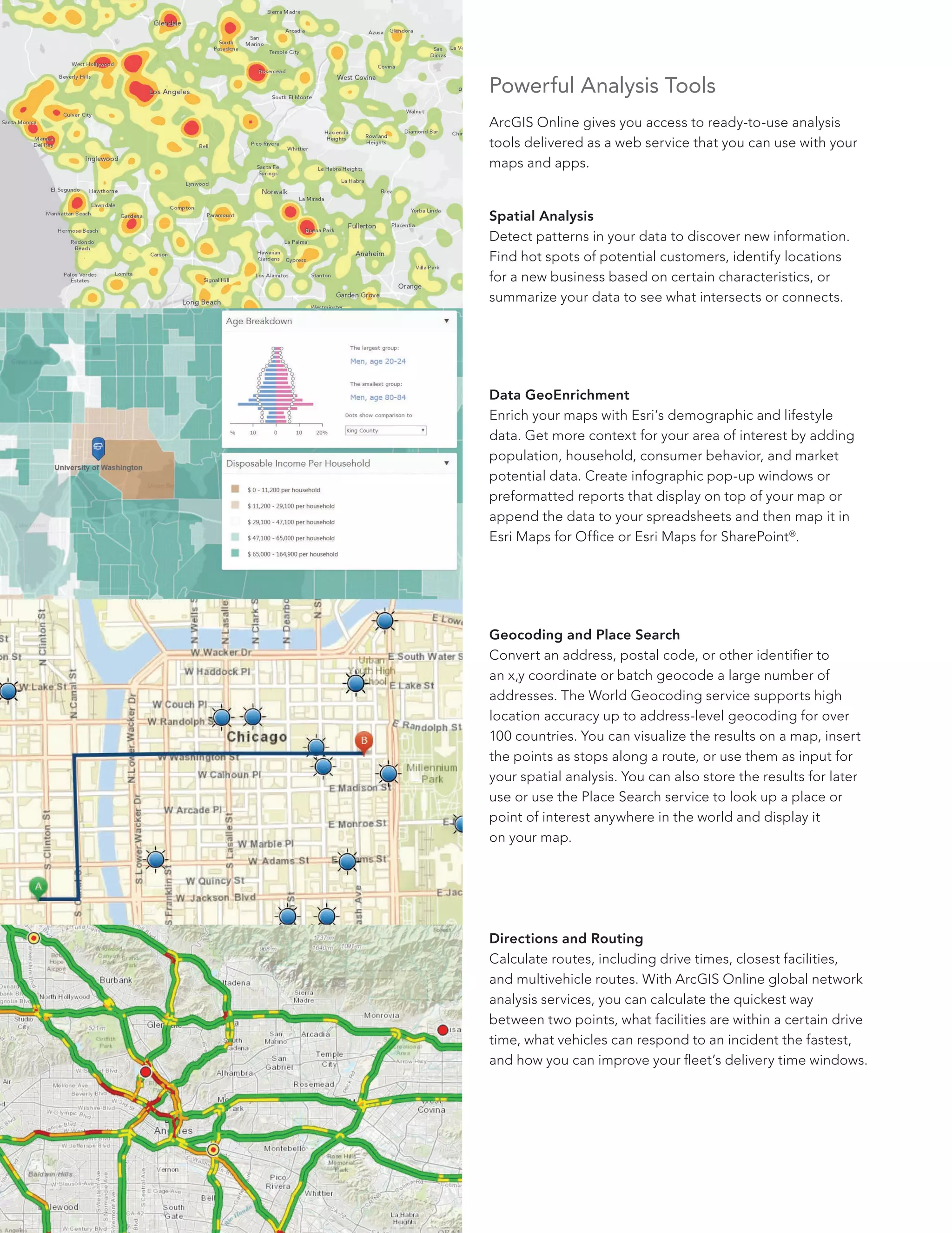
ArcGIS Online geocode services transform textual address data into precise geographic coordinates (latitude and longitude) that can be visualized on maps or analyzed spatially. By leveraging Esri’s global reference data, users can batch-process vast datasets, integrate location intelligence into web applications, and automate address validation workflows within the broader ArcGIS ecosystem as of 2026.
Understanding the ArcGIS Online Geocoding Service
Geocoding is the computational process of converting street addresses, city names, ZIP codes, or points of interest into map coordinates. ArcGIS Online provides this capability through the World Geocoding Service, a hosted web service that utilizes high-accuracy reference data sourced from reputable commercial and government providers.
Unlike desktop-based geocoding, which may require local reference datasets and significant hardware overhead, the ArcGIS Online geocoding service is cloud-native. It allows users to perform single-address lookups, batch geocoding of thousands of records, and reverse geocoding (converting coordinates back into human-readable addresses) without maintaining a local locator database.
Prerequisites and Eligibility
To utilize the geocoding capabilities within ArcGIS Online, you must hold a valid organizational account with appropriate user permissions. Access is primarily managed through user roles defined by the organization's administrator.
Licensing and Service Credits
ArcGIS Online operates on a service-credit model for geocoding operations. Credits are the digital currency used to perform tasks that consume cloud resources, such as batch geocoding. Before initiating large-scale projects, organizations must:
- Verify Credit Balance: Ensure the organization has sufficient service credits to cover the intended volume of address matches.
- Assign Privileges: Ensure the user profile includes the "Geocoding" privilege, which allows for the creation of new hosted feature layers from spreadsheet data.
- Configure Locators: Administrators must enable the World Geocoding Service within the organization settings if they wish to allow members to use it as a default for map searches and data enrichment.
Practical Implementation: How to Geocode Data
Geocoding data in ArcGIS Online typically follows a standard workflow, whether you are using the web interface or an automated API approach.
Step 1: Data Preparation
Clean your data before ingestion. Ensure your CSV or Excel file contains columns clearly labeled as "Address," "City," "State," and "ZIP Code." Ambiguous data—such as misspelled street names or missing administrative units—reduces the accuracy of the geocoding result.
Step 2: Upload and Geocode
- Navigate to the Content tab in your ArcGIS Online portal.
- Click New Item and upload your source file (CSV or Excel).
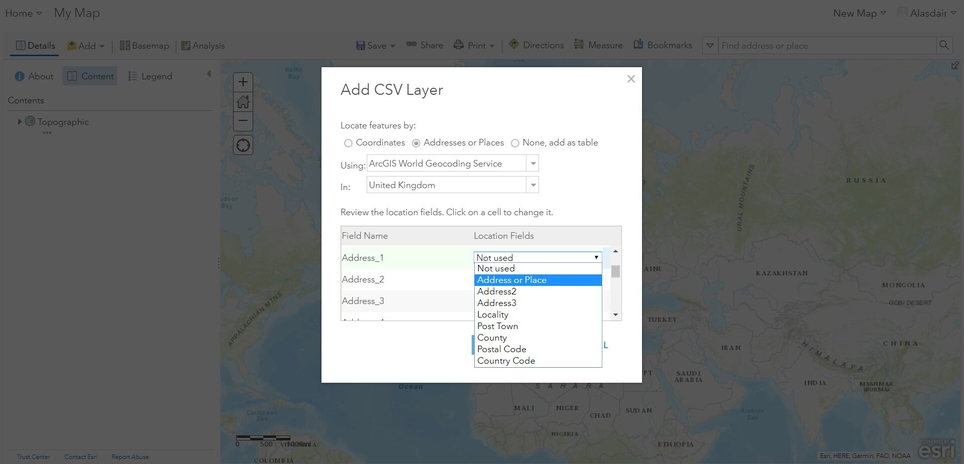
- ArcGIS Online will prompt you to "Locate features" based on the data columns. Map your spreadsheet columns to the suggested address fields.
- Review the location settings. You can specify a "Country" or "Category" filter (e.g., only searching for addresses within the United States) to improve the speed and precision of the matching process.
- Publish the resulting data as a Hosted Feature Layer.
Step 3: Troubleshooting Mismatched Addresses
If your dataset returns low match rates, investigate the "Review Matches" interface. This tool allows users to manually adjust the candidate locations for addresses that were not automatically resolved. Common reasons for failures include:
- Incomplete Data: Missing house numbers or incorrect postal codes.
- Language Mismatch: Attempting to geocode addresses in a language not natively supported by the specific locator profile.
- Ambiguity: Addresses that exist in multiple locations within the reference dataset.
Comparison of Geocoding Methods
Depending on the scale of your project and your technical requirements, different methods of geocoding within the ArcGIS ecosystem provide varying levels of control and cost-efficiency.
| Method | Best For | Technical Complexity | Credit Consumption |
|---|---|---|---|
| Web Map Interface | One-off small batches | Low | Moderate |
| ArcGIS Pro | Large datasets/heavy cleaning | High | High (depending on volume) |
| ArcGIS REST API | Custom application integration | Very High | Variable (Usage-based) |
| ArcGIS Maps for Office | Business reporting/Sales data | Low | Moderate |
Integration with ArcGIS REST API
For developers building custom web or mobile applications, the ArcGIS REST API provides direct access to the World Geocoding Service. This allows for "on-the-fly" geocoding, where a user types an address into a search bar, and the application displays the coordinate results instantly.
To implement this, you must register your application in the ArcGIS Developer portal to obtain an API Key. This key authenticates your requests and tracks service credit consumption. Unlike the web interface, which is meant for static data processing, the API is designed for interactive, high-concurrency environments. Ensure that your application handles geocoding errors gracefully by providing users with a "No Result Found" notification when an address is not identifiable.
Best Practices for Cost Management
Since ArcGIS Online charges credits based on the number of addresses geocoded, inefficient workflows can lead to unexpected costs.
- Filter Before You Geocode: Never upload a large dataset containing thousands of records if you only need a subset. Use SQL filters or Excel to remove redundant entries before initiating the geocoding process.
- Cache Results: If your application performs repeated lookups for the same set of addresses, store the resulting coordinates in your own database. This avoids paying the credit cost for re-geocoding identical information.
- Use Precise Locators: When configuring your job, be as specific as possible regarding the region or country. Narrowing the search scope forces the engine to ignore non-relevant geographic data, which improves both performance and match accuracy.
Frequently Asked Questions
1. Does ArcGIS Online support geocoding outside of the United States? Yes. The World Geocoding Service supports address data from over 100 countries. However, the level of precision varies based on the underlying reference data available for specific regions. Always check the official Esri coverage map to ensure the regions you are targeting have the desired level of detail (e.g., rooftop versus street-level accuracy).
2. What should I do if my address points are landing in the wrong place? Verify your input formatting. If you are geocoding an entire country but the results are defaulting to the center of the country, you likely have a missing administrative field. Adding "Country" and "State" columns to your input data forces the geocoder to constrain its search to the correct jurisdiction.
3. Can I use my own address data to create a custom locator? Yes, but this is handled through "Locator" creation in ArcGIS Pro, not directly in the ArcGIS Online web interface. Once you create a custom locator, you can publish it as a service to your organization’s ArcGIS Enterprise or ArcGIS Online account.
4. How long does the geocoding process take? The speed depends on the complexity of the query and current service load. Small datasets usually process in seconds, while batches of over 100,000 records may require several minutes. For extremely large datasets, consider performing the operation in smaller chunks of 10,000 records.
5. Are there alternatives to the Esri World Geocoding Service? Yes. While the World Geocoding Service is tightly integrated into the ArcGIS ecosystem, advanced users sometimes use third-party geocoding APIs. These can be integrated via Python scripts or custom widgets, but they lack the seamless, out-of-the-box compatibility with ArcGIS symbology and spatial analysis tools.
Next Steps for Success
To effectively master ArcGIS Online geocoding, prioritize establishing a clean data pipeline. Before you perform your first batch job, audit your source data for standardized naming conventions. If you are managing an enterprise account, review your organization’s credit usage reports in the Status tab to identify peak usage times and adjust your data processing schedule to align with organizational budgets. If you encounter consistent issues with match accuracy, consider utilizing the ArcGIS Pro geocoding tools, which offer more granular control over locator candidates and match scores than the web-based version.