An ancient civilizations India map visually delineates the spatial distribution of urban centers, regional kingdoms, and trade networks across the Indian subcontinent from the Bronze Age through the classical period. Understanding this geography requires examining how natural river basins, mountain passes, and coastal corridors shaped civilizations ranging from the Indus Valley to the southern Chola Dynasty.
Geographical Framework of the Ancient Indian Subcontinent
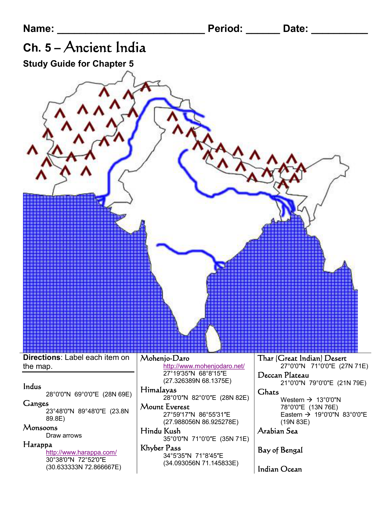
The geography of the Indian subcontinent—historically referred to in Sanskrit texts as Jambudvipa or Bharatvarsha—dictated the settlement patterns, agricultural viability, and military movement of early human societies. Bounded by the Himalayas and Hindu Kush ranges to the north and northwest, and surrounded by the Arabian Sea, Indian Ocean, and Bay of Bengal to the west, south, and east, the subcontinent formed a distinct geographical unit with several ecological micro-zones.
Cartographers and historians divide the ancient landscape into four primary geographic regions:
- The Indus River Basin: Encompassing modern-day Punjab, Sindh, Khyber Pakhtunkhwa, Gujarat, and Rajasthan, this arid and semi-arid zone relied on seasonal flooding from the Indus River system to support intensive urban agriculture.
- The Indo-Gangetic Plain: Extending from the Yamuna and Ganges rivers down to the Bay of Bengal delta, this fertile alluvial corridor became the heartland of post-Vedic urbanization, population expansion, and imperial consolidation.
- The Deccan Plateau: A vast elevated triangular region bounded by the Vindhyas and Satpura ranges to the north, and the Western and Eastern Ghats to the sides. This rugged terrain created a natural buffer between northern imperial powers and southern regional states.
- The Peninsular Coastal Plains and Deep South (Tamilakam): The fertile deltas of the Mahanadi, Godavari, Krishna, and Kaveri rivers supported maritime polities that traded across the Arabian Sea and the Indian Ocean.
Mountain passes in the northwest, notably the Khyber, Bolan, and Gomal passes, served as the primary terrestrial gateways for migration, trade, and military incursions, connecting the subcontinent to the Iranian Plateau and Central Asia.
Chronological Mapping of Ancient Indian Civilizations
Mapping ancient India is not a static task. Over four millennia, political boundaries shifted fluidly alongside environmental transformations, such as the desiccation of major river channels. A comprehensive historical map must be understood through five distinct chronological eras.
Ancient Indian Chronology:
- Bronze Age (c. 3300 – 1300 BCE): Indus Valley Civilization
- Vedic & Iron Age (c. 1500 – 600 BCE): Gangetic Settlement & Kuru-Panchala
- Second Urbanization (c. 600 – 345 BCE): 16 Mahajanapadas
- Imperial Era (c. 322 BCE – 550 CE): Maurya & Gupta Empires
- Peninsular & Southern Era (c. 300 BCE – 800 CE): Satavahanas & Sangam Period
The Indus Valley Civilization (c. 3300–1300 BCE)
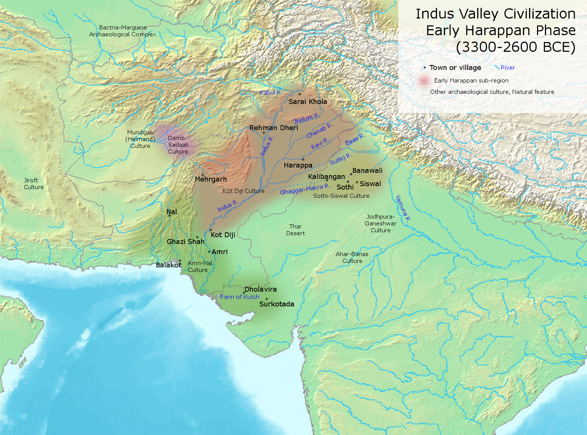
The earliest complex urban society on the subcontinent was the Indus Valley Civilization (IVC), also known as the Harappan Culture. At its peak during the Mature Harappan phase (c. 2600–1900 BCE), the IVC covered over 1 million square kilometers—an area larger than contemporary Bronze Age Egypt or Mesopotamia.
Indus Valley Civilization:
- Shortugai (North - Bactria Trade Outpost)
- Taxila Region
- Harappa
- Rakhigarhi / Kalibangan (East/Ghaggar-Hakra)
- Mohenjo-daro
- Sutkagan Dor (West - Makran)
- Dholavira
- Lothal (South - Maritime Hub)
Key geographical nodes on a Harappan map include:
- Harappa: Located along a former course of the Ravi River in modern Punjab, Pakistan, serving as a northern hub for timber, metals, and agricultural distribution.
- Mohenjo-daro: Situated on the right bank of the lower Indus River in Sindh, Pakistan, featuring advanced brick urban planning, public baths, and sophisticated drainage networks.
- Rakhigarhi: Located in Haryana, India, recognized as one of the largest physical sites of the IVC, spanning over 350 hectares along the dried bed of the ancient Drishadvati River.
- Dholavira: Located on Khadir Bet island in the Great Rann of Kutch, Gujarat, famous for its stone masonry, complex water reservoirs, and tri-partite city structure.
- Lothal: A southern coastal settlement in Gujarat featuring a brick structure identified by archaeologists as a tidal dockyard, facilitating trade with the Persian Gulf.
- Sutkagan Dor: The westernmost known Harappan outpost, situated near the Iranian border along the Makran coast, functioning as a maritime trading station.
The gradual drying of the Ghaggar-Hakra river system, combined with shifting monsoon patterns, led to the de-urbanization of the IVC around 1900 BCE, moving settlements eastward toward the upper Ganges basin.
The Vedic Period and the 16 Mahajanapadas (c. 1500–345 BCE)
During the Iron Age, economic activity shifted to the Indo-Gangetic Plain. By 600 BCE, this transition triggered the "Second Urbanization," marked by the emergence of 16 prominent territorial states known as the Mahajanapadas (Great Realms).
16 Mahajanapadas Regional Distribution:
- Gandhara
- Kamboja
- Kuru
- Panchala
- Matsya
- Kosala
- Vajji / Malla
- Surasena
- Vatsa
- Kasi
- Anga
- Magadha
- Avanti
- Chedi
- Assaka (Godavari Basin)
Historical maps of this era group these states across distinct geographic sectors:
- Northwestern Zone: Gandhara (capital Taxila) and Kamboja (Pamir/Hindukush region), controlling overland silk and horse trade routes.
- Central Northern Zone: Kuru (around modern Delhi/Haryana), Panchala (upper Ganges), Kosala (capital Ayodhya/Sravasti), and Vatsa (capital Kausambi).
- Eastern Gangetic Zone: Magadha (capital Rajagriha, later Pataliputra), Anga (capital Champa), Vajji (a confederacy centered at Vaishali), and Malla (around Kusinara). Magadha leveraged local iron ore deposits in Chota Nagpur to conquer neighboring states.
- Central and Southern Zone: Avanti (capital Ujjain), controlling central Indian trade hubs, and Assaka (Asmaka), located along the Godavari River—the southernmost Mahajanapada.
Imperial Unification: Maurya and Gupta Empires (c. 322 BCE–550 CE)
The unification of regional polities produced expansive pan-subcontinental empires. Map representations of these empires show distinct territorial extent and administrative centers:
Mauryan & Gupta Realms:
- Taxila (Northern Viceroyalty)
- Ujjain (Western Trade Hub)
- Pataliputra (Imperial Capital / Gangetic Hub)
- Tosali (Eastern Kalinga)
- Suvarnagiri (Southern Deccan Control)
- Pataliputra (Imperial Capital / Gangetic Hub)
- Ujjain (Western Trade Hub)
The Mauryan Empire (c. 322–185 BCE)
Founded by Chandragupta Maurya and expanded by Ashoka the Great, the Mauryan Empire marked the political unification of nearly the entire subcontinent. Its borders extended from modern Afghanistan and Balochistan in the west to Bengal in the east, and southward to northern Karnataka.
Maps of the Mauryan realm are anchored by the locations of Ashoka’s Rock and Pillar Edicts, discovered at sites such as Shahbazgarhi (Pakistan), Girnar (Gujarat), Sanchi (Madhya Pradesh), and Dhauli (Odisha). The imperial capital was Pataliputra (modern Patna), situated at the confluence of the Ganges and Son rivers.
The Gupta Empire (c. 319–550 CE)
Often characterized as the Classical Age of Indian art and science, the Gupta Empire held direct administrative control over the Indo-Gangetic Plain, with tributary states extending into the Punjab, central India, and along the eastern coast. Major geographic centers included Pataliputra, Ujjain, and Prayaga (Allahabad). Ujjain emerged as the primary western astronomical and commercial center.
Peninsular Empires and the Deep South (c. 300 BCE–800 CE)
Southern Indian geography created distinct historical development patterns isolated from northern imperial control by the Vindhya range.
Peninsular & Southern Regions:
Satavahana Dynasty Domain (Pratishthana / Amaravati)
- Chera Realm (Kanchi/Muziris)
- Chola Realm (Uraiyur/Kaveri)
- Pandya Realm (Madurai/Korkai)
The Satavahana Dynasty (c. 1st Century BCE – 2nd Century CE): Operating across the Deccan Plateau between the Godavari and Krishna river valleys, the Satavahanas bridged northern and southern trade routes. Key centers included Pratishthana (Paithan) and Amaravati.
The Sangam Landscape (Tamilakam): The southern tip of India was divided among three ruling houses:
- The Cheras: Controlled the western Malabar Coast (modern Kerala), operating out of the major spice port of Muziris.
- The Cholas: Controlled the fertile Kaveri River delta on the eastern coast, centered around Uraiyur and the coastal port of Poompuhar (Kaveripattinam).
- The Pandyas: Ruled the southernmost region from the inland capital of Madurai and the pearl-diving port of Korkai.
The Pallavas and Chalukyas (c. 6th–8th Centuries CE): The Chalukyas dominated the upper Deccan from Badami (Vatapi), while the Pallavas established an empire centered at Kanchipuram, developing the maritime port of Mamallapuram (Mahabalipuram).
Spatial Matrix of Ancient Indian Civilizations
The following matrix compares the core geographical zones, eras, and primary urban sites across major Indian civilizations:
| Era / Civilization | Time Horizon | Core Geographic Zone | Primary Cities / Archaeological Sites | Key Physical Landmarks |
|---|---|---|---|---|
| Early Harappan / IVC | c. 3300 – 1900 BCE | Indus & Ghaggar-Hakra River Basins, Gujarat | Harappa, Mohenjo-daro, Dholavira, Rakhigarhi, Lothal | Indus River, Rann of Kutch, Hakra Riverbed |
| Vedic Culture | c. 1500 – 600 BCE | Punjab plains to Upper/Middle Gangetic Plain | Hastinapura, Ahichchhatra, Ayodhya | Yamuna River, Ganges River, Doab region |
| Mahajanapadas | c. 600 – 345 BCE | Northern & Central India, Godavari valley | Pataliputra, Ujjain, Taxila, Kausambi, Vaishali | Gangetic Valley, Vindhya Range foothills |
| Mauryan Empire | c. 322 – 185 BCE | Pan-subcontinental (excluding deep south) | Pataliputra (Capital), Taxila, Ujjain, Tosali | Chota Nagpur Plateau, Khyber Pass, Bay of Bengal |
| Satavahana Realm | c. 100 BCE – 200 CE | Deccan Plateau, Godavari-Krishna Basin | Pratishthana, Amaravati, Junnar | Western Ghats, Godavari River, Krishna River |
| Gupta Empire | c. 319 – 550 CE | North & Central India, Gangetic Heartland | Pataliputra, Prayaga, Ujjain, Mathura | Ganges-Yamuna Doab, Malwa Plateau |
| Early Tamil Kingdoms | c. 300 BCE – 300 CE | Southern Peninsular Tip (Tamilakam) | Madurai, Uraiyur, Muziris, Poompuhar | Kaveri Delta, Malabar Coast, Coromandel Coast |
| Chalukya / Pallava | c. 550 – 750 CE | Central Deccan & Coromandel Coast | Badami, Aihole, Kanchipuram, Mamallapuram | Malaprabha River, Palar River, Eastern Ghats |
Physical Geography and Ancient Trade Networks
The positioning of ancient Indian settlements depended heavily on physical features and overland trade arteries.
Overland and Maritime Trade Networks:
- TAXILA (Northwest Gateway)
- Uttarapatha (Northern Arterial Highway)
- MATHURA
- VARANASI
- PATALIPUTRA
- TAMRALIPTI (Sea Routes to Southeast Asia)
- Dakshinapatha (Southern Trade Route)
- UJJAIN
- PRATISHTHANA
- BAY OF BENGAL PORTS
- BARIGAZA / BHARUCH (Arabian Sea Port)
- PRATISHTHANA
- UJJAIN
- Uttarapatha (Northern Arterial Highway)
River Systems as Urban Engines
Every major ancient settlement developed along a perennial river. Rivers provided drinking water, natural defense, deposit of nutrient-rich alluvial silt during floods, and inland navigation.
- The Indus River supported the early agricultural surpluses of Harappan urban centers.
- The Ganges-Yamuna System enabled rapid boat transportation of goods and troops, helping Magadha unify northern India.
- The Kaveri River supported high agricultural yields in southern India, funding the monumental architecture of the Chola kingdom.
Overland Highways: Uttarapatha and Dakshinapatha
Two arterial trade networks traversed ancient maps:
- Uttarapatha (The Great Northern Road): Stretched from the northwestern frontier city of Taxila, passing through Mathura, Kanyakubja (Kannauj), Varanasi, and Pataliputra, down to the deltaic port of Tamralipti (modern Tamluk, West Bengal). This route carried raw materials, lapis lazuli, horses, and silk across northern Asia.
- Dakshinapatha (The Southern Highway): Branched off from the Gangetic system at Varanasi and Kausambi, heading south through Ujjain, crossing the Narmada River at Mahishmati, and running through Pratishthana down into the deep south. This route carried spices, precious gemstones, gold, and textiles from the Deccan and peninsular coast to northern markets.
Coastal Topography and Maritime Port Geography
Ancient maps highlight major coastal ports that facilitated trade with the Roman Empire, East Africa, the Persian Gulf, and Southeast Asia.
Coastal Ports and Maritime Trade:
Barigaza / Bharuch (Gujarat)
- Arabian Sea Trade
Muziris (Kerala - Pepper Coast)
Cape Comorin
Arikamedu / Kaveripattinam (Tamil Coast)
- Bay of Bengal Trade
Tamralipti (Bengal Delta)
Barigaza (Bharuch): Situated on the estuary of the Narmada River in Gujarat, serving as the chief western port for Greco-Roman maritime trade, as documented in the 1st-century CE text Periplus of the Erythraean Sea.
Muziris (Pattanam): Located on the Malabar Coast of Kerala, serving as the central hub for the ancient global black pepper trade. Roman merchant vessels brought gold coins (aurei) to Muziris in exchange for spices, malabathrum, and beryl.
Arikamedu: Located near modern Puducherry on the Coromandel Coast, functioning as a major manufacturing and trading center. Archaeological excavations here revealed Roman amphorae, terra sigillata glassware, and bead-making workshops.
Tamralipti: Located near the mouth of the Ganges, serving as the primary embarkation point for Buddhist monks, scholars, and merchants sailing toward Sri Lanka and Southeast Asia.
Detailed archaeological reports on maritime ports, trade routes, and excavation maps are curated by the Archaeological Survey of India.
Locating Major Archaeological Sites on Modern Maps
Because ancient political entities rarely match modern administrative borders, locating historical sites on contemporary maps requires matching historical names with modern geographic coordinates and administrative jurisdictions:
| Ancient Site Name | Modern Equivalent / District | Country |
|---|---|---|
| Harappa | Sahiwal District, Punjab | Pakistan |
| Mohenjo-daro | Larkana District, Sindh | Pakistan |
| Taxila (Takshashila) | Rawalpindi District, Punjab | Pakistan |
| Pataliputra | Patna, Bihar | India |
| Ujjain (Ujjayini) | Ujjain District, Madhya Pradesh | India |
| Kausambi | Kaushambi District, Uttar Pradesh | India |
| Dholavira | Kutch District, Gujarat | India |
| Rakhigarhi | Hisar District, Haryana | India |
| Muziris | Pattanam, Ernakulam, Kerala | India |
| Kanchipuram | Kanchipuram District, Tamil Nadu | India |
Modern archaeological mapping uses satellite imagery, LiDAR, and geographic information systems (GIS) to uncover buried urban grids, dried river channels, and subsurface structural footprints. For example, satellite survey mapping confirmed that the ancient Sarasvati River ran parallel to the Indus before desiccating around 1900 BCE due to tectonic and climatic shifts.
For research on World Heritage sites like Dholavira and Mohenjo-daro, cartographic data and site surveys are available through the UNESCO World Heritage Centre.
Common Misconceptions When Reading Ancient Indian Maps
Interpreting historical cartography of the Indian subcontinent requires avoiding several analytical pitfalls:
- Conflating Modern Political Boundaries with Ancient Regions: Modern state borders (India, Pakistan, Bangladesh, Afghanistan) did not exist in antiquity. Regions such as Gandhara spanned modern eastern Afghanistan and northern Pakistan, while the Indus Valley Civilization spanned both Pakistan and northwestern India.
- Assuming Fixed Imperial Borders: Unlike modern nation-states with surveyed boundaries, ancient Indian empires operated on a mandala system—concentric circles of direct control, indirect vassalage, and tributary influence. Maps showing solid blocks of color for the Mauryan or Gupta empires reflect maximum spheres of influence rather than uniform direct governance.
- Ignoring Environmental and Hydrological Changes: Coastlines, deltaic formations, and river courses have shifted significantly over three millennia. The Rann of Kutch was more navigable in the Harappan era, and rivers like the Sutlej and Yamuna altered their paths, directly triggering the decline of settlements along their former beds.
- Neglecting Peninsular and Southern Developments: Historical maps occasionally focus heavily on northern Gangetic empires, oversimplifying the complex political cartography of peninsular India, where trade networks, maritime technology, and urban centers developed independently under the Satavahanas, Cheras, Cholas, Pandyas, and Pallavas.
Frequently Asked Questions
What was the earliest mapped civilization in ancient India?
The earliest urban civilization on the Indian subcontinent was the Indus Valley Civilization (also known as the Harappan Civilization), which flourished from c. 3300 BCE to 1300 BCE. Its urban sites stretched across modern-day Pakistan, northwestern India, and parts of northeast Afghanistan.
How did river systems shape the ancient map of India?
River systems provided essential resources for urban development, agricultural irrigation, and trade highways. The Indus system supported the early Bronze Age Harappan sites, while the Ganges-Yamuna river basin enabled the Second Urbanization, fostering cities like Pataliputra, Varanasi, and Kausambi. In the south, the Godavari, Krishna, and Kaveri river deltas served as the agricultural foundations for the Satavahana, Chola, and Pandya kingdoms.
What were the 16 Mahajanapadas and where were they located?
The 16 Mahajanapadas were major oligarchic republics and monarchies that emerged across northern, central, and western India during the 6th century BCE. They spanned from Gandhara in modern Pakistan and Afghanistan to Anga in Bengal, and as far south as Assaka on the Godavari River. Magadha, situated in modern-day Bihar, eventually conquered the other realms to establish India's first major empires.
Why do maps of ancient India include regions in Pakistan and Afghanistan?
Ancient India refers to a geographic and cultural space—the Indian subcontinent—bounded by the Himalayas, the Hindu Kush, and the Indian Ocean. Critical cultural, intellectual, and trade hubs of ancient Indian history, such as Harappa, Mohenjo-daro, and Taxila, were located along the Indus River basin and northwestern mountain passes in areas that are part of modern Pakistan and Afghanistan.
What main trade routes connected ancient Indian cities?
The two main overland trade highways were the Uttarapatha (connecting the northwestern frontier to the eastern Bengal coast via the Gangetic plain) and the Dakshinapatha (connecting northern urban hubs like Varanasi and Ujjain to the Deccan Plateau and southern peninsula). Maritime trade routes linked coastal ports like Barigaza and Muziris to the Roman Empire and the Persian Gulf across the Arabian Sea, while ports like Tamralipti and Poompuhar connected to Southeast Asia across the Bay of Bengal.
Next Steps for Cartographic and Historical Research
To further analyze ancient Indian historical geography:
- Examine Primary Source Maps: Consult the Atlas of the Historical Geography of South Asia or regional survey maps generated by academic institutions.
- Study Epigraphic Records: Cross-reference physical maps with Ashokan rock edicts, copper-plate grants, and Roman trade journals like the Periplus of the Erythraean Sea.
- Explore GIS Archaeological Databases: Review open-access digital mapping projects maintained by international archaeological teams to explore high-resolution spatial data of Harappan, Vedic, and Sangam sites.