Atlanta rarely sees snow because its humid subtropical climate is dominated by warm air from the Gulf of Mexico, which frequently pushes freezing temperatures northward. Significant snowfall requires a precise, rare alignment of deep moisture and sustained Arctic air, a combination that historically occurs only once or twice per winter season.
For residents and visitors in the "Capital of the South," the sight of a snowflake is often more of a mathematical anomaly than a seasonal guarantee. While northern cities prepare for winter with industrial-scale salt reserves and fleets of snowplows, Atlanta operates in a state of atmospheric tension. As we look at the climate landscape in 2026, the city’s relationship with winter remains defined by volatility rather than consistency.
To understand why Atlanta rarely sees snow, one must look beyond simple temperature readings and explore the complex interplay of geography, moisture sources, and the unique Appalachian topography that dictates North Georgia’s weather patterns.
The Statistical Reality of Atlanta Winters
Statistically, Atlanta receives an average of approximately 1.9 to 2.2 inches of snow per year, based on the 30-year climate normals provided by the National Oceanic and Atmospheric Administration (NOAA). However, these averages are notoriously misleading. In the Southeast, "average" is rarely the "norm."
Atlanta’s winter weather is characterized by "boom or bust" cycles. In some years, such as 2025 or the early 2020s, the city might record only a "trace" amount—meaning snowflakes were sighted but did not accumulate. In other years, a single significant event can dump four to six inches in a day, skewing the decade's average upward.
The Seasonal Window
The window for potential snowfall in Atlanta is narrow, typically stretching from late December through early March. January is historically the snowiest month, followed closely by February. However, because the ground temperature in Georgia stays relatively high compared to the Midwest or Northeast, even when snow falls, it often melts upon contact unless the rate of snowfall is high enough to overcome the Earth's latent heat.
The Meteorological Barriers to Snowfall
The primary reason Atlanta rarely sees snow is its geographic location at 33.7°N latitude. At this position, the city is frequently influenced by the subtropical jet stream, which carries mild, moist air from the Gulf of Mexico across the Deep South. For snow to form and reach the ground in Atlanta, three specific conditions must be met simultaneously—a feat that is meteorologically difficult to achieve.
1. The Moisture Pump vs. The Arctic Front
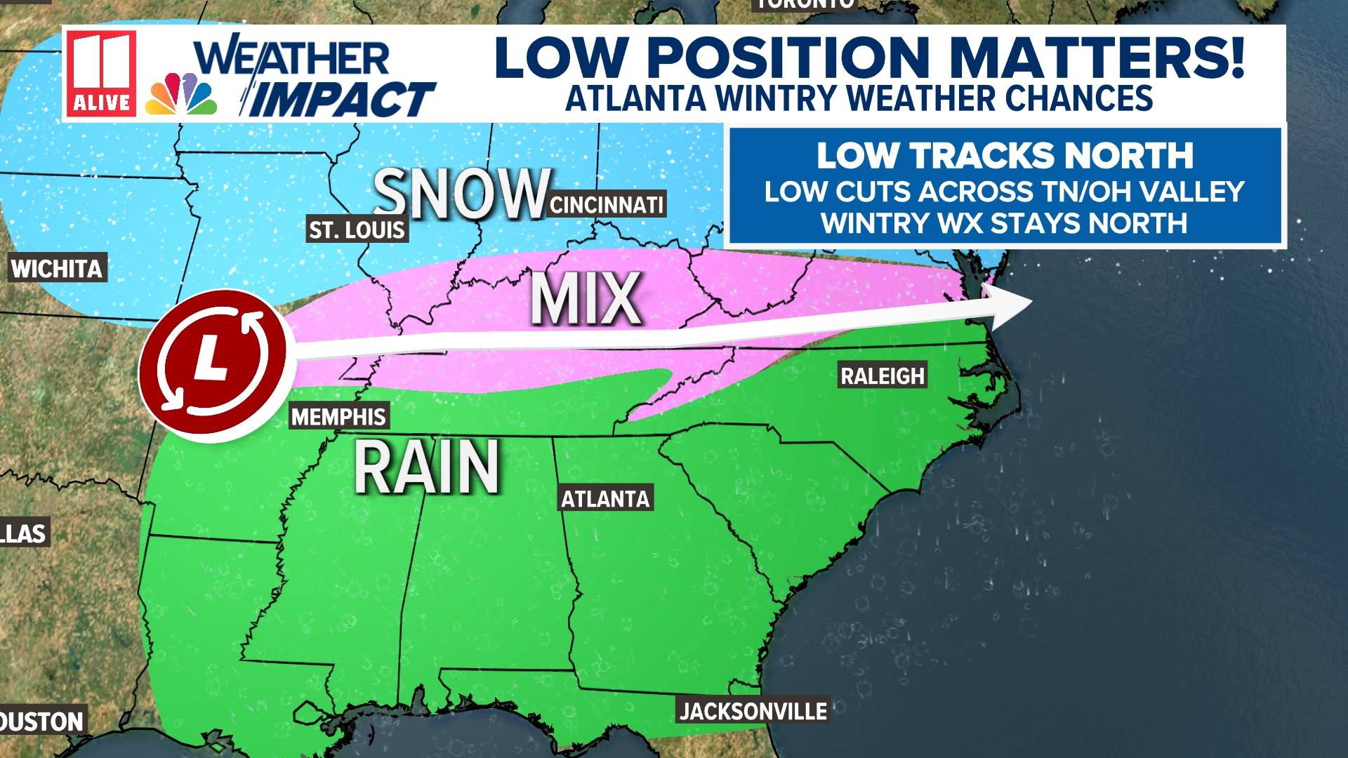
Snow requires moisture, but in Atlanta, moisture almost always arrives with warmth. Storm systems typically track from the Southwest (the Gulf) toward the Northeast. These systems are inherently "warm-core" or transition into "warm-sector" events for Georgia. By the time a cold front from Canada (an Arctic "clipper" or a Siberian high-pressure system) arrives to provide the necessary freezing temperatures, the moisture has usually already moved offshore into the Atlantic.
2. The "Rain-Snow Line" Struggle
Atlanta often sits directly on the "rain-snow line." A difference of just one or two degrees Celsius in the middle layers of the atmosphere determines whether the city sees fluffy snow, freezing rain, or just a cold, miserable drizzle. If a layer of warm air exists between the clouds and the ground—a common occurrence in the South—the snow melts into rain or sleet before it ever hits the pavement.
3. Cold Air Damming (The "Wedge")
One of the most unique features of Atlanta’s weather is Cold Air Damming (CAD), colloquially known as "The Wedge." This occurs when high pressure over New England or the Mid-Atlantic pushes cold, dense air southward along the eastern side of the Appalachian Mountains. The mountains act as a barrier, "damming" the cold air against the peaks and forcing it into the Georgia Piedmont.
While the Wedge provides the cold air necessary for winter weather, it often creates a "shallow" cold layer. This leads to ice storms rather than snowstorms. Because the cold air is hugged tight to the ground while warmer air flows over the top of the mountains, precipitation falls as rain, freezes in the cold air near the surface, and creates dangerous ice accumulations.
The Urban Heat Island Effect
As Atlanta has grown into a massive metropolitan area, the Urban Heat Island (UHI) effect has become a significant factor in why the city center rarely sees the same snowfall totals as its suburbs.
The vast amounts of concrete, asphalt, and steel in Downtown, Midtown, and Buckhead absorb solar radiation during the day and release it slowly at night. Furthermore, the heat generated by millions of vehicles and climate-control systems in high-rise buildings keeps the local atmosphere slightly warmer than the surrounding rural areas.
It is common for "The Perimeter" (Interstate 285) to act as a thermal boundary. On many winter nights, areas like Milton, Alpharetta, or Woodstock may see an inch of accumulation, while the City of Atlanta sees only rain or a slushy mix because the urban core is 2–4 degrees warmer.
Historical Context: When the Rarity Breaks
To understand why Atlanta is so cautious about its rare snow, one must look at the events that occur when the atmospheric stars do align. These "outlier" events define the city’s emergency protocols.
| Event Name/Year | Snowfall Total (Inches) | Primary Impact |
|---|---|---|
| The Great Blizzard of 1993 | 4.2" | Known as the "Storm of the Century"; caused massive power outages and high winds. |
| The 2011 "Snowpocalypse" | 4.4" | Grounded flights at Hartsfield-Jackson for days and shut down the city for a week. |
| The 2014 "Snowmageddon" | 2.6" | Created a historic traffic gridlock where commuters were stranded on highways for 18+ hours. |
| December 2017 Surprise | 6.0" | An early-season heavy wet snow that caught meteorologists by surprise with its intensity. |
| Average Winter (2020-2026) | 0.0" - 1.5" | Mostly trace events or light dustings that melt within 24 hours. |
The 2014 Case Study
The 2014 event remains the quintessential example of why Atlanta’s rare snow is so disruptive. Only about 2.6 inches fell, which would be a non-event in Buffalo or Minneapolis. However, because it rarely snows, the city lacked the pre-treatment infrastructure and the volume of snowplows needed to clear major arteries simultaneously. The snow quickly compacted into solid ice under the weight of tires, turning the interstate system into a skating rink and stranding thousands of school children and workers.
The Infrastructure of Rarity
Because Atlanta rarely sees snow, it is not fiscally responsible for the city to maintain a massive fleet of snow-clearing equipment that might only be used once every three years. Instead, the Georgia Department of Transportation (GDOT) and the City of Atlanta focus on brining—applying a saltwater solution to roads before a storm to prevent ice from bonding to the asphalt.
Why the City Shuts Down
When a "Winter Weather Advisory" is issued for Atlanta, schools and businesses often close immediately. This is not due to "softness," as northern transplants often joke, but due to a calculated risk assessment:
- Lack of Equipment: Most Atlanta residents do not own snow tires or all-wheel-drive vehicles.
- Topography: Atlanta is incredibly hilly. Even a small amount of ice makes the rolling terrain of neighborhoods like Virginia-Highland or Cascade Heights impassable.
- The Ice Factor: Because temperatures in Atlanta often hover right at the freezing mark, snow frequently melts and then refreezes into black ice overnight. This is far more dangerous than the deep, dry snow found in colder climates.
Climate Trends and the 2026 Outlook
As we operate in 2026, the long-term trend for Atlanta's winter weather continues to show a decrease in the frequency of "minor" snow events, while the potential for "extreme" moisture events remains. According to research from organizations like the National Weather Service, warming global temperatures mean the atmosphere can hold more moisture.
For Atlanta, this typically translates to more winter rain. However, on the rare occasion that an Arctic blast does successfully "wedge" into Georgia, the increased moisture can lead to heavier, wetter snow events than those seen in the mid-20th century. The rarity of snow is increasing, but the volatility of the storms that do break through remains high.
How to Prepare for Atlanta’s Rare Winter Events
For those living in or moving to the Atlanta area, the rarity of snow means that preparation is often overlooked until a storm is 24 hours away.
- Monitor the "Dew Point": Meteorologists in Atlanta watch the dew point closely. If the air is too dry, snow will evaporate before hitting the ground (virga). If it is too high, it stays as rain.
- Home Insulation: Southern homes are built to repel heat, not necessarily to retain it during sub-freezing stretches. Ensuring pipes are wrapped is critical, as the rare deep freezes that accompany snow can easily burst exposed plumbing.
- Supplies: Because the supply chain in the South is not hardened for winter weather, a two-inch snow forecast often leads to "bread and milk" runs that empty grocery store shelves. Maintaining a three-day supply of essentials throughout January and February is a standard local recommendation.
Frequently Asked Questions
Does it snow every year in Atlanta?
No, it does not snow every year in Atlanta. While the city averages about two inches annually, that number is a long-term mathematical average. It is quite common for Atlanta to go two or three consecutive years with only "trace" amounts of snow that do not accumulate on the ground.
Why is 2 inches of snow a "disaster" in Atlanta?
The primary issue is the temperature cycle. In Atlanta, snow usually falls when temperatures are near 32°F (0°C). This causes the initial snow to melt on the roads and then refreeze into a layer of solid ice as the sun goes down. Furthermore, the city’s hilly topography and lack of widespread salt-spreading equipment make even thin layers of ice extremely hazardous for standard vehicles.
What is the best month to see snow in Atlanta?
Historically, January is the most likely month for snowfall in Atlanta, followed by February. Most significant historical storms have occurred in the window between January 10th and February 20th. Snow in December or March is rare but not unheard of.
Why does it rain so much instead of snowing in Georgia?
The proximity to the Gulf of Mexico provides a constant source of warm, moist air. For snow to occur, a very specific "trough" in the jet stream must pull cold air far enough south to meet that moisture. Usually, the cold air stays too far north, or the moisture stays too far south, resulting in a cold, rainy day rather than a snowy one.
Is the "Wedge" the same as a snowstorm?
Not necessarily. The "Wedge" (Cold Air Damming) is a pressure setup that brings cold air into the region. While it is a prerequisite for many snow events, it more frequently results in freezing rain or sleet because it creates a thin layer of cold air at the surface while warmer air remains aloft.
Practical Recommendations for Residents
Given that Atlanta rarely sees snow, the best course of action for residents is anticipatory caution. When a winter weather system is forecasted, do not wait for the first flake to fall before adjusting your schedule.
- Commute Planning: If you work in the Metro area, try to be off the roads at least four hours before the precipitation is expected to start. The 2014 crisis was caused largely by everyone attempting to leave work at the same time the snow began to stick.
- Emergency Kits: Keep a small kit in your car including a blanket, water, and a portable phone charger. In the rare event of a "flash freeze," you may be forced to wait for road crews to clear ice from major inclines.
- Infrastructure Awareness: Follow the Georgia Department of Transportation (GDOT) on social media for real-time updates on brine applications and road closures.
Atlanta's winter beauty is fleeting and unpredictable. While the city may not offer the consistent white winters of the North, the rarity of snow in Georgia makes the occasional dusting a momentous—and occasionally challenging—event for the entire region.