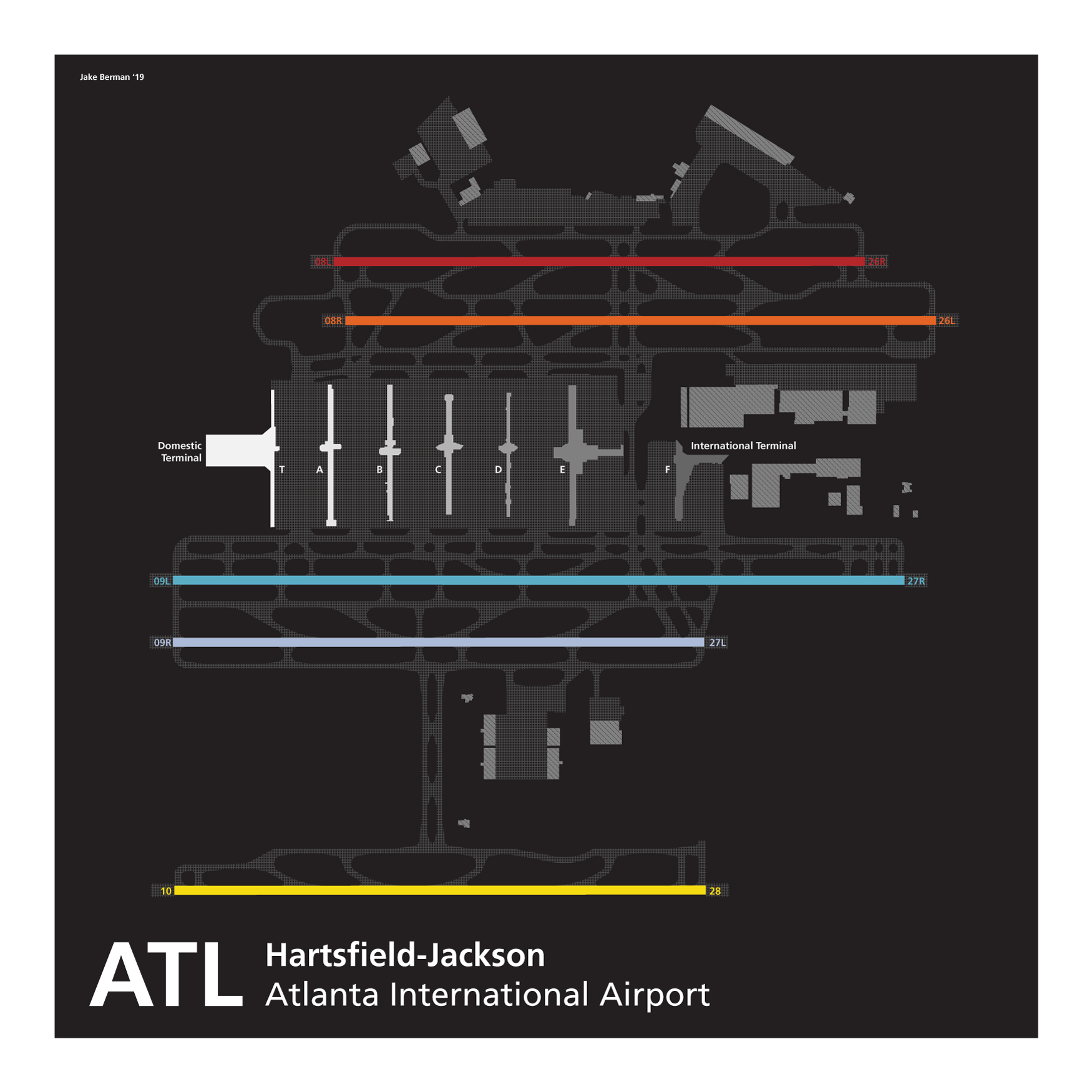
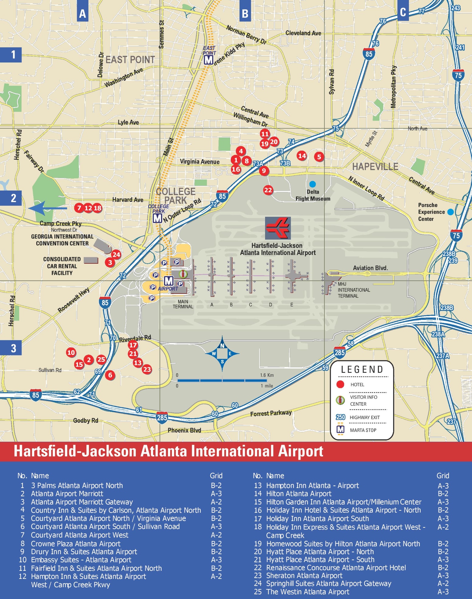
The newly unveiled 2026 Hartsfield-Jackson Atlanta International Airport (ATL) map provides a comprehensive digital and physical guide to the world’s busiest travel hub. It features the completed Concourse D widening, integrated real-time security wait times, and a revolutionized indoor positioning system designed to streamline gate-to-gate navigation for millions of annual passengers.
Understanding the 2026 Hartsfield-Jackson Airport Layout
Hartsfield-Jackson Atlanta International Airport has long been recognized for its efficient, linear design, often referred to as a "spine" layout. The 2026 map unveiling marks a significant milestone in the airport's multi-billion dollar modernization program, ATLNext. This updated layout is essential for navigating the massive complex, which spans over 6.8 million square feet of terminal space.
The airport is divided into two primary terminal buildings located at opposite ends of the concourse "spine": the Domestic Terminal to the west and the Maynard H. Jackson Jr. International Terminal to the east. Between these two terminals lie seven parallel concourses—T, A, B, C, D, E, and F—connected underground by the Plane Train and a pedestrian walkway equipped with moving sidewalks.
The 2026 map is particularly significant because it officially incorporates the structural changes made to Concourse D. For years, Concourse D was the narrowest point in the airport, creating bottlenecks for travelers. The newly unveiled maps show a significantly wider footprint, with expanded hold rooms and upgraded amenities that align with the aesthetic of the newer International Terminal. This architectural shift is not just cosmetic; it changes the flow of foot traffic and the placement of retail and dining options, making an updated map a prerequisite for even frequent Atlanta travelers.
Key Features of the New Interactive Digital Wayfinding System
Coinciding with the physical map updates, the airport has launched an enhanced interactive digital wayfinding system. This system is accessible via the official airport website, mobile applications, and high-definition kiosks located throughout the terminal. Unlike static maps of the past, the 2026 digital version uses Indoor Positioning System (IPS) technology to provide "blue dot" navigation, similar to GPS but optimized for indoor environments where satellite signals are weak.
Real-Time Security Wait Times and Mobility Integration
One of the most valuable features of the 2026 map is the integration of live data. Travelers can see real-time wait times for the North, South, and Lower Level security checkpoints within the Domestic Terminal directly on the map interface. This allows passengers to make informed decisions about which entrance to use based on current congestion.
Furthermore, the map now includes a "Mobility Mode." This feature is specifically designed for passengers using wheelchairs or those with limited mobility. It highlights the most efficient routes that utilize elevators instead of escalators and identifies the nearest ADA-compliant restrooms and charging stations for electric mobility devices. By selecting a destination, the map provides a step-by-step path that avoids stairs and narrow corridors, ensuring a seamless experience for all travelers.
Gate-to-Gate Navigation for International Connections
For those connecting between domestic and international flights, the new map clarifies the transition between the two "sides" of the airport. While the Plane Train connects all concourses, the map now emphasizes the distinction between Concourse E and Concourse F (the International Terminal).
The digital map provides estimated walking and transit times between any two points in the airport. If a traveler arrives at Gate A10 and needs to reach Gate F12 for an international departure, the map will calculate the time required to walk to the Plane Train station, the transit time to Concourse F, and the final walk to the gate. This level of precision helps mitigate the stress of tight connection windows.
Terminal-by-Terminal Breakdown: Domestic vs. International
Navigating Atlanta requires understanding where you need to check in and claim your baggage. The 2026 map clarifies these distinctions, which are often a source of confusion for those unfamiliar with the "Atlanta Jackson" layout.
The Domestic Terminal (North and South)
The Domestic Terminal is located on the west side of the airport. It is split into two sides:
- Terminal North: Historically serves airlines like American, United, Southwest, and various smaller carriers.
- Terminal South: Exclusively serves Delta Air Lines, which maintains its primary hub in Atlanta.
The 2026 map highlights the shared Atrium, a large central area between North and South that houses the majority of the terminal's pre-security dining and retail. The map also clearly marks the locations of the Ground Transportation Center and the MARTA (Metropolitan Atlanta Rapid Transit Authority) station, which provides direct rail access to downtown Atlanta.
The Maynard H. Jackson Jr. International Terminal
Located on the east side, the International Terminal (Concourse F) is a self-contained facility with its own check-in, security, and baggage claim. The 2026 map shows how Concourse F integrates with Concourse E to form the international complex. Travelers arriving from abroad who are ending their journey in Atlanta must exit through the International Terminal. However, those connecting to domestic flights will follow the map’s guidance through the sterile corridor to the Plane Train, which takes them back toward the domestic concourses.
Navigating the Concourse D Expansion and Modernization
The centerpiece of the 2026 map update is the completed Concourse D Widening Project. For decades, Concourse D was approximately 60 feet wide, which felt cramped during peak travel times. The modernization has expanded the concourse to over 90 feet in width.
The updated map reveals:
- Expanded Seating Areas: Increased capacity at every gate to accommodate larger aircraft and more passengers.
- New Culinary and Retail Hubs: The wider layout allowed for the introduction of several high-end dining options and local Atlanta brands that were previously unable to fit in the narrow space.
- Upgraded Restrooms: The map identifies the new "smart restrooms" that use sensors to alert maintenance staff of cleaning needs and provide real-time occupancy data to passengers.
This expansion has also led to a renumbering and slight repositioning of some gates. Travelers are encouraged to verify their gate location on the new 2026 map rather than relying on memory from previous years.
Transportation Within the Airport: Plane Train and SkyTrain
Atlanta is famous for its internal transit systems, and the 2026 map provides detailed visuals for both the Plane Train and the ATL SkyTrain.
The Plane Train
The Plane Train is the underground automated people mover that runs the length of the concourse spine. The 2026 map highlights the West Extension, which was designed to improve the turnaround efficiency of the trains and reduce wait times during peak hours. The map shows the stations located at the center of every concourse (T, A, B, C, D, E, and F) and the Domestic Terminal.
The ATL SkyTrain
The SkyTrain is an elevated train located outside the Domestic Terminal. It connects passengers to:
- The Gateway Center: Home to the Georgia International Convention Center and several hotels.
- The Rental Car Center (RCC): All rental car operations are consolidated here.
- West Parking Deck: The map shows the direct pedestrian bridge connections from the SkyTrain to the newest parking facilities.
| Transit Method | Destination | Frequency | Estimated Travel Time |
|---|---|---|---|
| Plane Train | Concourses T through F | Every 2-3 minutes | 2-15 minutes total |
| ATL SkyTrain | Rental Car Center / Hotels | Every 3-5 minutes | 5 minutes |
| Pedestrian Walkway | Between Concourses (T-F) | N/A | 5-30 minutes (walking) |
| MARTA Rail | Downtown / Midtown Atlanta | Every 10-20 minutes | 20-30 minutes |
Parking and Ground Transportation Map Updates
With the 2026 unveiling, the airport has also updated its parking maps to reflect the completion of the South Parking Deck reconstruction and the expansion of the West Parking Deck.
Parking at Hartsfield-Jackson is now categorized into several tiers on the map:
- Hourly Parking: Located directly in front of the terminals for short-term use.
- Daily Parking: Multi-level decks adjacent to the terminals.
- Economy Parking: Located slightly further away but within walking distance.
- ATL West Parking: Connected via the SkyTrain, offering a high-tech, ticketless entry system.
- Park-Ride Lots: Off-site lots served by frequent shuttle buses, clearly marked on the ground transportation map.
The ground transportation map also identifies specific zones for Ride-Share services (Uber and Lyft), which are located at the North and South Domestic Terminals and the International Terminal. These zones are color-coded to match the signage travelers will see on the ground.
Tips for Efficient Navigation at the World’s Busiest Airport
To make the most of the 2026 map and the airport’s facilities, travelers should consider the following expert recommendations:
- Download the Digital Map Offline: While the airport offers free Wi-Fi, having a cached version of the map on your mobile device ensures you have access even in areas with spotty connectivity.
- Check the "Concourse Flow" Indicators: The new interactive map uses heat-mapping technology to show which concourses are currently most crowded. If you have a long layover, you might find a quieter environment in a different concourse.
- Identify Service Animal Relief Areas (SARAs): For those traveling with pets or service animals, the 2026 map marks indoor and outdoor relief areas located in every concourse.
- Locate Power Stations: The 2026 updates have significantly increased the number of charging stations. The map highlights "Power Zones" where integrated USB-C and standard outlets are plentiful.
Frequently Asked Questions
How do I get from the Domestic Terminal to the International Terminal?
To travel between terminals, you can use the Plane Train if you are already past security. If you are pre-security (landside), you must take the terminal-to-terminal shuttle bus. The 2026 map shows the shuttle pick-up points at the Ground Transportation Center of the Domestic Terminal and the arrivals level of the International Terminal. The drive takes approximately 15-20 minutes.
Can I walk between all the concourses in Atlanta?
Yes, there is a pedestrian walkway that runs parallel to the Plane Train tracks underground. The 2026 map highlights the various art installations located in these walkways, such as the "A Walk Through the History of Atlanta" exhibit between Concourses B and C, and the "Rain Forest" installation between the Domestic Terminal and Concourse A. Walking the entire length from the Domestic Terminal to Concourse F takes approximately 30-40 minutes at a brisk pace.
Where is the new Concourse D widening reflected on the map?
The 2026 map shows a noticeably wider rectangular footprint for Concourse D compared to older maps. The gate numbers have been updated to reflect the new layout, and the central corridor is now twice as wide as the previous version, with new clusters of shops and restaurants clearly labeled.
How does the interactive map show security wait times?
The digital map pulls live data from sensors at the North, South, and International security checkpoints. On the interactive map, these are represented by color-coded icons (Green for under 15 minutes, Yellow for 15-30, and Red for over 30). This allows you to choose the most efficient entry point before you even arrive at the terminal.
What is the "Atlanta Jackson" airport's official name?
While often referred to as "Atlanta Jackson" or simply "Atlanta Airport," the official name is Hartsfield-Jackson Atlanta International Airport (ATL). It was named to honor former Atlanta mayors William B. Hartsfield and Maynard Jackson.
Practical Recommendation for Travelers
For anyone traveling through Atlanta in 2026, the most practical action is to access the Official Hartsfield-Jackson Interactive Map at least 24 hours before your flight. Because the airport is constantly evolving under the ATLNext initiative, gate configurations and construction detours can change. By familiarizing yourself with the 2026 layout—specifically the distinction between the North/South Domestic sides and the International Terminal—you can significantly reduce travel anxiety and ensure a more efficient journey through the world's most traveled airport.