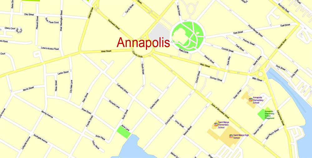
For travelers visiting Annapolis in 2026, the most effective tourist map is a hybrid of the physical Official Visitors Map available at the 26 West Street Visitors Center and the Historic Annapolis digital interface. These maps highlight the city’s unique "circles and spokes" layout, pinpointing the Maryland State House, the U.S. Naval Academy, and the bustling City Dock waterfront.
Annapolis, Maryland, remains one of the most walkable historic cities in the United States. However, its 17th-century street plan—designed by Governor Francis Nicholson in 1695—can be notoriously disorienting for first-time visitors. A high-quality Annapolis tourist map is not just a convenience; it is a vital tool for understanding the city’s complex geography, finding accessible parking, and ensuring you do not miss the hidden brick alleyways that house some of the region's best culinary and historical gems.
Types of Annapolis Tourist Maps Available in 2026
Navigating a city that predates the American Revolution requires different tools depending on your mode of transport and specific interests. In 2026, visitors generally choose between three primary mapping formats.
The Official Printed Visitors Map
Despite the prevalence of smartphones, the physical fold-out map remains a staple for Annapolis tourists. These are produced by Visit Annapolis & Anne Arundel County and are updated annually to reflect changes in business locations and monument access. These maps are particularly useful because they provide a high-level overview of the "Historic District" versus "Eastport," helping visitors visualize the distance across the Spa Creek Bridge. You can pick these up at:
- The Visitors Center (26 West Street): The primary hub for physical brochures.
- The City Dock Information Booth: Located near the Kunta Kinte-Alex Haley Memorial.
- Hotel Concierge Desks: Most downtown hotels like the Graduate or Historic Inns of Annapolis keep these in stock.
Interactive Digital and Mobile Apps
For those who prefer real-time data, the Historic Annapolis (HA) mobile app offers an augmented reality experience. This digital map allows you to overlay historical photos of buildings as they appeared in the 18th and 19th centuries over your current GPS location. Additionally, the city’s official parking app, ParkMobile, integrates a map of real-time garage availability, which is essential given the limited street parking in the historic core.
Thematic and Specialized Maps
If your visit has a specific focus, general maps might lack the detail you need. Specialized maps include:
- The USNA Campus Map: Specifically for the United States Naval Academy. It highlights public access gates (primarily Gate 1) and visitor-accessible buildings like Bancroft Hall and the Naval Academy Chapel.
- Maritime Heritage Maps: Focused on Eastport and the "Maritime Republic," highlighting boat yards, the Annapolis Maritime Museum, and water taxi stops.
- African American Heritage Trail Maps: These guide visitors through significant sites like the Banneker-Douglass Museum and the various stops on the Underground Railroad network within the city.
Understanding the "Circles and Spokes" Layout
When looking at an Annapolis tourist map, the first thing you will notice is the two prominent circles: State Circle and Church Circle. Understanding these is the key to never getting lost.
State Circle
This is the highest point in the city and houses the Maryland State House. On your map, you will see several "spokes" radiating from this circle, including School Street, North Street, and Maryland Avenue. State Circle is a one-way loop. If you are walking, this is your primary landmark; as long as you are walking uphill toward the State House, you are heading toward the center of the historic district.
Church Circle
Located just a block away from State Circle, Church Circle surrounds St. Anne’s Episcopal Church. This circle acts as the gateway to the West Street corridor (the Arts District). It connects the modern parts of the city with the colonial core. Maps often highlight the transition here, as the architecture shifts from modern glass and concrete to 18th-century Flemish bond brickwork.
Mapping the Waterfront: City Dock and Ego Alley
The "bottom" of the map is dominated by the water. This area is known as City Dock, often referred to by locals as Ego Alley because of the high-end yachts that cruise the narrow waterway to see and be seen.
When using your map to navigate the waterfront, look for these specific markers:
- The Kunta Kinte-Alex Haley Memorial: Located at the water’s edge, marking the site where Alex Haley’s ancestor arrived in 1767.
- The Market House: A central hub for quick food and local goods, situated right at the foot of Main Street.
- Water Taxi Stops: Maps will indicate small yellow icons along the dock. These are pickup points for the water taxi, which provides a scenic way to cross over to Eastport without walking across the bridge.
Parking and Transportation Mapping
One of the biggest mistakes tourists make is trying to drive directly to City Dock without checking a parking map first. The streets are narrow, many are one-way, and street parking is strictly regulated.
Key Parking Garages on the Map
In 2026, the city utilizes a "Park and Ride" philosophy. Your map should highlight the following garages:
- Hillman Garage: Rebuilt and modernized, this is the closest garage to Main Street and City Dock.
- Knighton and Gotts Court Garages: Located further up West Street, these are often cheaper and serve as the starting point for the free downtown shuttle.
- Park Place Garage: Located at the entrance to the city, ideal for those who want to avoid the narrowest historic streets entirely.
The Magenta Shuttle Route
Most modern Annapolis tourist maps include a dashed line or a specific color-coded route for the Magenta Shuttle. This is a free circulator bus that runs from the outer parking garages down to City Dock. Using the map to find the nearest shuttle stop can save you a 15-to-20-minute walk in the Maryland summer humidity.
| Map Source | Best For | Features | Format |
|---|---|---|---|
| Visit Annapolis Official | General Tourism | Landmarks, Dining, Public Restrooms | Paper & PDF |
| Historic Annapolis App | History Buffs | AR Overlays, Audio Guides, House Museums | Mobile App |
| USNA Visitor Map | Military Interest | Security Gates, Bancroft Hall, Chapel | Digital & Print |
| Annapolis City Parking | Practicality | Real-time Garage Capacity, Shuttle Stops | Mobile App |
| Eastport Walking Map | Local Vibe | Pubs, Boat Yards, Maritime Museum | Paper/Brochure |
Essential Landmarks to Locate on Your Map
To make the most of your day, ensure these five locations are marked on your Annapolis tourist map:
- Maryland State House: The oldest state capitol in continuous legislative use and the site where George Washington resigned his commission as Commander-in-Chief.
- William Paca House and Garden: A restored 18th-century mansion with a stunning two-acre wilderness garden that is often hidden behind high brick walls—you'll need the map to find the entrance on Prince George Street.
- U.S. Naval Academy Gate 1: Located at the intersection of King George Street and Randall Street. Note that all visitors over 18 must show a valid government-issued ID to enter.
- Banneker-Douglass Museum: The state’s official museum of African American heritage, located on Franklin Street near Church Circle.
- Main Street: The primary commercial artery, filled with shops and restaurants. It slopes steeply down from Church Circle to the water.
Navigating Eastport: Across the Spa Creek Bridge
Many tourists never leave the historic core, which is a mistake. If you look at the bottom-right of your Annapolis map, you will see a bridge crossing Spa Creek. This leads to Eastport, a neighborhood with a distinct, more laid-back maritime identity.
Navigating Eastport is simpler than the "Circles" of downtown, as it follows a more traditional grid. The map will help you find the "Street End Parks"—tiny slivers of public land at the end of every street that offer benches and views of the Naval Academy across the water. The Annapolis Maritime Museum & Park is located at the far end of Eastport and is a primary destination for those interested in the ecology of the Chesapeake Bay and the history of the oyster industry.
Practical Tips for Map Usage in Annapolis
- Check for Road Closures: In 2026, Annapolis frequently hosts festivals like the Boat Shows (October) and the Maryland Day celebrations (March). During these times, the tourist map's traffic flow may change significantly, with certain streets becoming pedestrian-only zones.
- Scale is Deceiving: The Historic District is smaller than it looks on paper. You can walk from the Visitors Center on West Street to City Dock in about 10–12 minutes. Don't be intimidated by the number of streets.
- Restroom Icons: Public restrooms are limited. The most reliable ones are at the Market House (City Dock), the Visitors Center (West Street), and the Hillman Garage. Mark these on your map early.
- The "Hidden" Alleys: Some of the best photo opportunities are in the alleys like Pinkney Street or Fleet Street. These are often marked as thin lines on detailed tourist maps and contain original colonial-era workers' cottages.
Frequently Asked Questions
Where can I get a free Annapolis tourist map?
Free physical maps are available at the Annapolis Visitors Center at 26 West Street and the Information Booth at City Dock. Digital versions can be downloaded for free from the official Visit Annapolis website. Most downtown hotels also provide them at no cost to guests.
Does the map show the U.S. Naval Academy grounds?
General tourist maps show the perimeter of the Academy and the main gates. However, because the USNA is an active military installation, the internal paths can change based on security levels. It is recommended to use the specific USNA Visitor Map provided at the Armel-Leftwich Visitor Center inside Gate 1 for the most accurate internal navigation.
Is the Annapolis tourist map mobile-friendly?
Yes, the city has transitioned many of its resources to mobile-friendly formats. The "Visit Annapolis" app includes an interactive map with filters for dining, shopping, and historical sites. Additionally, Google Maps is highly accurate for Annapolis, though it may not label all the specific historical house museums as clearly as the dedicated tourist maps.
Are there maps specifically for accessible routes?
The historic district’s brick sidewalks can be uneven and challenging for strollers or wheelchairs. The official 2026 visitors map includes notations for accessible paths, highlighting areas with curb cuts and smoother surfaces. West Street and parts of the Naval Academy are generally the most accessible areas.
How do I find the water taxi stops on the map?
On most Annapolis maps, water taxi stops are indicated by a yellow boat icon or a "WT" symbol. There are primary stops at City Dock, Chart House (Eastport), and several marinas along Spa Creek and Back Creek.
Final Recommendation for Your Visit
To experience Annapolis fully in 2026, start your journey at the 26 West Street Visitors Center. Pick up the physical "Official Visitors Map" for a tactile sense of the city's history, but keep your smartphone ready with the Historic Annapolis app for deep-dive information on the 18th-century landmarks. Begin your walk at Church Circle, head down the "spokes" toward the water, and always keep the Maryland State House dome in your line of sight as your primary navigational anchor.