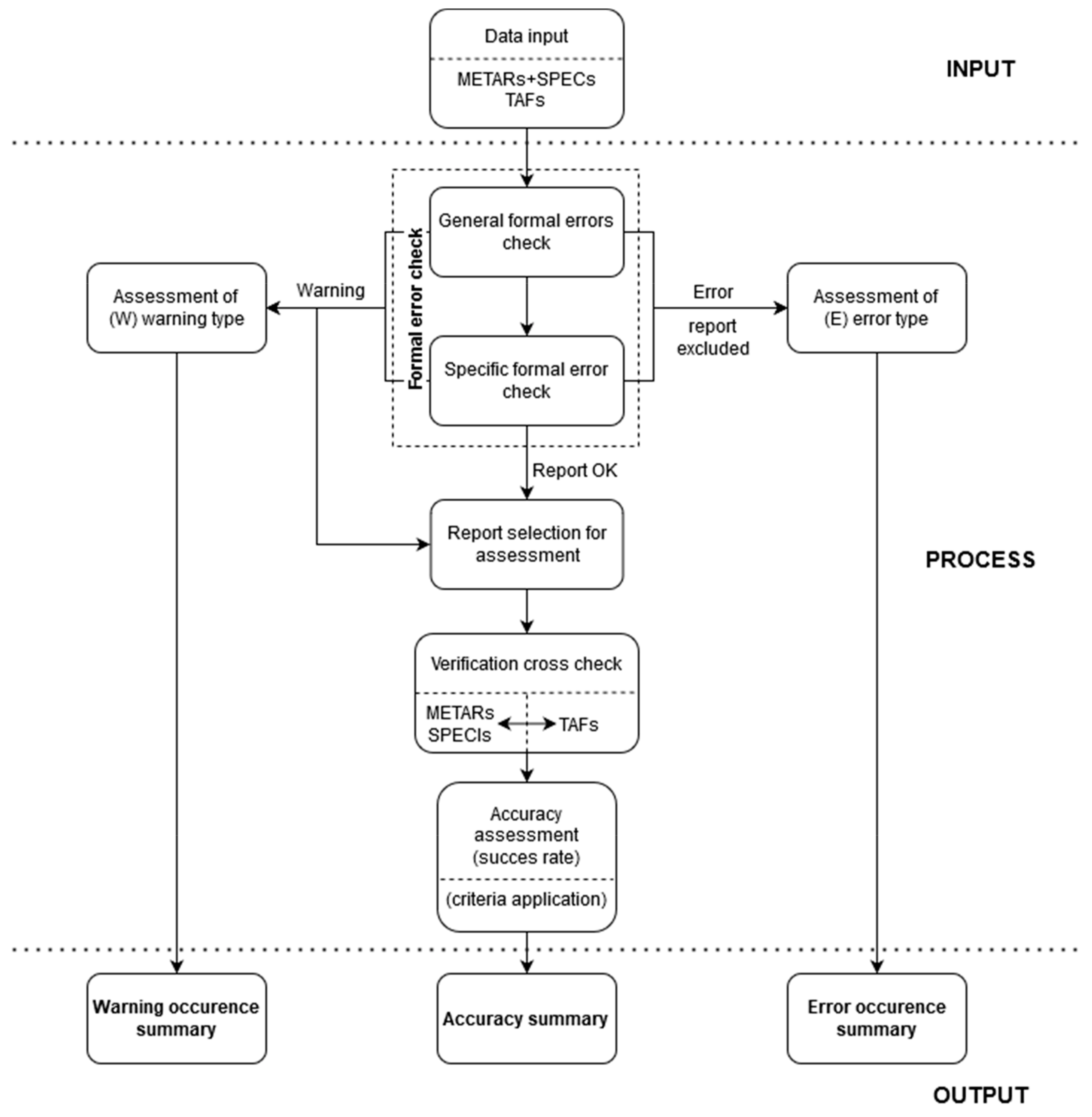
A SPECI is an unscheduled aviation weather report issued when significant changes in meteorological conditions occur between routine METAR broadcasts. It serves as a critical safety update for pilots and air traffic controllers, highlighting sudden deteriorations or improvements in visibility, ceiling, wind, or hazardous weather phenomena that could impact flight operations.
The world of aviation relies on precision, and few things require more precision than weather reporting. While routine observations provide a steady pulse of atmospheric conditions, the atmosphere is rarely static. When the weather takes an unexpected turn, the standard hourly report—the METAR—is no longer sufficient. This is where the SPECI (Aviation Selected Special Weather Report) becomes the primary tool for situational awareness.
As of 2026, the fundamental structure of these reports remains governed by international standards set by the World Meteorological Organization (WMO) and the International Civil Aviation Organization (ICAO), with local variations managed by national bodies like the FAA in the United States. Understanding the nuances of a SPECI report is essential for anyone involved in flight planning, dispatch, or active cockpit management.
The Definition of a SPECI Report
A SPECI is technically defined as an "Aviation Selected Special Weather Report." Unlike the METAR (Meteorological Aerodrome Report), which is issued at fixed hourly or half-hourly intervals, a SPECI is triggered by specific, predefined criteria. These criteria represent thresholds where the weather change is significant enough to affect the safety, efficiency, or legality of flight operations.
In the hierarchy of aviation weather products, the SPECI acts as an "interrupt" signal. It tells the aviation community that the last routine observation is now obsolete. For example, if a METAR was issued at 1400Z and the visibility was 10 miles, but a sudden heavy snow squall reduces visibility to 1/2 mile at 1415Z, waiting until the 1500Z METAR would be dangerous. The SPECI fills this gap, providing real-time data to ensure that pilots are not attempting approaches into conditions that have secretly fallen below minimums.
The Purpose of SPECI in Modern Aviation
The primary purpose of a SPECI report is to enhance safety and decision-making by communicating rapid changes in the terminal environment. Aviation is a high-stakes environment where "legal" weather can become "illegal" in a matter of minutes.
Supporting Tactical Decision Making
Pilots use SPECI reports to decide whether to continue an approach, enter a holding pattern, or divert to an alternate airport. If a SPECI indicates that the ceiling has dropped below the decision height (DH) for a specific instrument approach, the pilot knows immediately that a landing may not be possible. Conversely, a SPECI indicating an improvement in weather can signal that a previously closed runway is now accessible.
Alerting Air Traffic Control (ATC)
For controllers, a SPECI is a trigger to update ATIS (Automatic Terminal Information Service) broadcasts and to alert arriving and departing aircraft. It allows ATC to adjust spacing, change active runways, or implement low-visibility procedures (LVP) to maintain the safety of the airport surface and local airspace.
Liability and Regulatory Compliance
From a regulatory perspective, SPECIs provide a legal record of weather conditions at a specific moment. For commercial operators, following the data in a SPECI is not optional; it is a requirement of their Part 121 or Part 135 certificates. If a SPECI report shows conditions below landing minimums, an operator generally cannot begin the final approach segment.
Key Triggers: What Warrants a SPECI?
A SPECI is not issued for every minor fluctuation in wind or cloud cover. Specific thresholds must be crossed. While these can vary slightly by country, the following are the most common international triggers.
1. Wind Shifts and Speed Changes
Wind is one of the most frequent reasons for a SPECI. A report is typically required when:
- Directional Shift: The wind direction changes by 45 degrees or more in less than 15 minutes, provided the wind speed is at least 10 knots.
- Speed Increases: A significant increase in gusts occurs. Generally, if the mean speed increases by 10 knots or more over the previous report, a SPECI is warranted.
- Squalls: The onset or cessation of squalls (sudden, sharp increases in wind speed).
2. Visibility Thresholds
Visibility is a critical factor for Visual Flight Rules (VFR) and Instrument Flight Rules (IFR). A SPECI is usually issued when the prevailing visibility decreases to or passes through:
- 3 statute miles (the threshold for basic VFR).
- 2 statute miles.
- 1 statute mile (the common threshold for many standard IFR approaches).
- The lowest published instrument approach minimum for the airport (e.g., 1/2 mile or 1/4 mile).
3. Ceiling and Cloud Base
The "ceiling" is defined as the lowest layer of clouds reported as Broken (BKN) or Overcast (OVC). A SPECI is triggered when the ceiling drops below or rises above:
- 3,000 feet.
- 1,500 feet.
- 1,000 feet (the ceiling requirement for VFR).
- 500 feet.
- The lowest published landing minimums for any runway at the airport.
4. Hazardous Weather Phenomena
Certain weather events are so significant that their onset or cessation must be reported immediately, regardless of visibility or ceiling. These include:
- Thunderstorms: The beginning or ending of a thunderstorm at the station.
- Freezing Precipitation: The onset or cessation of freezing rain (FZRA) or freezing drizzle (FZDZ).
- Volcanic Ash: Any sighting of volcanic ash (VA).
- Tornadoes/Waterspouts: Any occurrence of a tornado (+FC) or funnel cloud (FC).
- Hail: The beginning or ending of hail (GR) or small hail (GS).
Key Elements of a SPECI Report
The format of a SPECI is identical to that of a METAR, which allows for rapid scanning and computer processing. Each report follows a specific sequence of "data blocks."
1. Report Type
The very first word in the report will be SPECI. This distinguishes it from a METAR. In many automated systems, even if a report is triggered by SPECI criteria, it may still be labeled as a METAR if it happens to coincide with the routine reporting time.
2. Station Identifier
The four-letter ICAO code for the airport (e.g., KJFK for New York JFK, EGLL for London Heathrow).
3. Date and Time of Observation
This is a six-digit group followed by "Z" (Zulu/UTC). The first two digits are the day of the month, and the last four are the hours and minutes. For a SPECI, this time reflects when the weather change met the criteria, not the top of the hour.
4. Report Modifier (Optional)
If the report is generated by an automated station without human intervention, the word AUTO will appear. If the report is a correction to a previous report, COR is used.
5. Wind
The wind group consists of five digits (six if the speed is over 99 knots). The first three are the direction in degrees from true north. The next two are the speed in knots (KT). If gusts are present, the letter "G" is followed by the peak gust speed.
6. Visibility
Reported in statute miles (SM) in the US or meters in international formats. This measures the greatest distance at which prominent objects can be seen and identified.
7. Present Weather
This block uses standard ICAO codes to describe precipitation, obscurations, or other phenomena. For example:
- +TSRA: Heavy Thunderstorm and Rain.
- -SN: Light Snow.
- FG: Fog (visibility less than 5/8 mile).
- BR: Mist (visibility 5/8 mile to 6 miles).
8. Sky Condition
Describes cloud cover in "octas" (eighths of the sky).
- FEW: 1/8 to 2/8.
- SCT (Scattered): 3/8 to 4/8.
- BKN (Broken): 5/8 to 7/8.
- OVC (Overcast): 8/8. The height of the cloud base is added in hundreds of feet (e.g., OVC005 means an overcast ceiling at 500 feet).
9. Temperature and Dewpoint
Reported in degrees Celsius. The two are separated by a slash (e.g., 12/10). If the temperature and dewpoint are close together, it indicates high humidity and the potential for fog formation.
10. Altimeter Setting
In the US, this is preceded by "A" and represents inches of mercury (e.g., A2992). Internationally, it is preceded by "Q" for Hectopascals (e.g., Q1013).
11. Remarks (RMK)
The remarks section contains supplemental data such as the exact time a thunderstorm began (TSRB), sea-level pressure (SLP), or the type of automated station (AO1 or AO2).
Comparing METAR and SPECI
| Feature | METAR | SPECI |
|---|---|---|
| Issuance Frequency | Scheduled (usually every hour) | Unscheduled (as needed) |
| Primary Trigger | Time-based | Event-based (weather change) |
| Format | Standard ICAO/WMO code | Standard ICAO/WMO code |
| Purpose | Routine monitoring and planning | Immediate safety alerts/Tactical updates |
| Typical Label | METAR | SPECI |
| Inclusion of AUTO | Yes (if automated) | Yes (if automated) |
Reading a SPECI: A Practical Example
Imagine the following report appears on a pilot’s electronic flight bag (EFB):
SPECI KATL 152115Z 28015G25KT 1/2SM +TSRA FG OVC004 18/17 A2985 RMK TSB10
Let’s decode this piece by piece:
- SPECI: This is a special, unscheduled report.
- KATL: The report is for Hartsfield-Jackson Atlanta International Airport.
- 152115Z: It was observed on the 15th day of the month at 21:15 UTC.
- 28015G25KT: Wind is from 280 degrees at 15 knots, gusting to 25 knots.
- 1/2SM: Visibility is very low, only 1/2 statute mile.
- +TSRA FG: Heavy thunderstorms and rain are occurring, with fog.
- OVC004: The sky is overcast at 400 feet.
- 18/17: Temperature is 18°C, dewpoint is 17°C (very high humidity).
- A2985: The altimeter setting is 29.85 inches of mercury.
- RMK TSB10: Remark: The thunderstorm began 10 minutes past the hour (21:10Z).
This SPECI tells a pilot that conditions at Atlanta have deteriorated significantly, likely due to a passing storm front. The combination of low visibility (1/2 SM) and low ceiling (400 feet) would put the airport in "LIFR" (Low Instrument Flight Rules) conditions.
The Role of Automation in SPECI Reporting
By 2026, the vast majority of airport weather observations are handled by automated systems like the ASOS (Automated Surface Observing System) or AWOS (Automated Weather Observing System). These systems are programmed with the SPECI criteria and can generate reports within seconds of a sensor detecting a threshold change.
However, automation has limitations. For instance, an automated system might not "see" a funnel cloud that is not directly over a sensor, or it might struggle to differentiate between heavy rain and small hail. In many major airports, human observers or "augmenters" still oversee the automated systems to ensure that SPECI reports are accurate and capture nuances that machines might miss.
Common Mistakes When Interpreting SPECI Reports
Even experienced professionals can misinterpret these reports. Some common errors include:
- Ignoring the Time Stamp: Pilots sometimes see a SPECI and assume it is the "current" weather, failing to check how many minutes have passed since its issuance. Weather can continue to change rapidly after a SPECI is released.
- Confusing SM and Meters: When flying internationally, mistaking 800 meters (roughly 1/2 mile) for 800 yards or miles can lead to dangerous errors in approach planning.
- Overlooking the Remarks Section: The RMK section often contains the "why" behind the report, such as peak wind directions or the movement of a storm cell.
- Assuming Improvements are Permanent: A SPECI showing a ceiling rise from 400 to 1,000 feet might be a temporary break in a storm. Pilots should look for "Trend" forecasts often appended to international SPECI reports.
Frequently Asked Questions
Is a SPECI always required when weather improves?
Yes. A SPECI is triggered by both deterioration and improvement. If the ceiling rises from 800 feet to 1,200 feet, it crosses the 1,000-foot threshold, which may allow VFR traffic to resume. Reporting improvements is just as critical for airport efficiency as reporting deteriorations is for safety.
How does a SPECI differ from a TAF?
A SPECI is an observation of what is happening right now. A TAF (Terminal Aerodrome Forecast) is a prediction of what will happen in the future. While a SPECI might trigger an update to a TAF (an AMD or Amended TAF), they are separate products.
Can a METAR be issued instead of a SPECI?
If the conditions that would trigger a SPECI occur at the same time as the routine hourly observation, the report is simply issued as a METAR. The METAR will contain all the relevant updated information, making a separate SPECI redundant.
What is the "Trend" part of a SPECI?
In many countries outside the United States, a "Trend" forecast is attached to the end of a SPECI. This is a brief, two-hour forecast (e.g., "NOSIG" for no significant change or "BECMG" for becoming) that tells the pilot if the conditions reported in the SPECI are expected to last.
Why did my airport stop issuing SPECIs?
Some smaller airports with limited hours or older automated systems may not have the capability to provide continuous 24-hour SPECI coverage. Pilots should check the Chart Supplement or NOTAMs to see the "Weather Reporting Requirements" for a specific airfield.
Summary of Next Actions for Pilots and Dispatchers
When a SPECI report is issued, it should trigger an immediate review of the flight's status. If you are in the cockpit, compare the new visibility and ceiling data against your approach plate minimums. If you are a dispatcher, check if the change in weather requires an amended flight plan or a change in the required fuel reserves for an alternate airport.
The SPECI is more than just a line of code; it is a vital communication link that bridges the gap between scheduled observations and the unpredictable reality of the atmosphere. By mastering the criteria and elements of these reports, aviation professionals ensure they are never caught off guard by the changing sky.