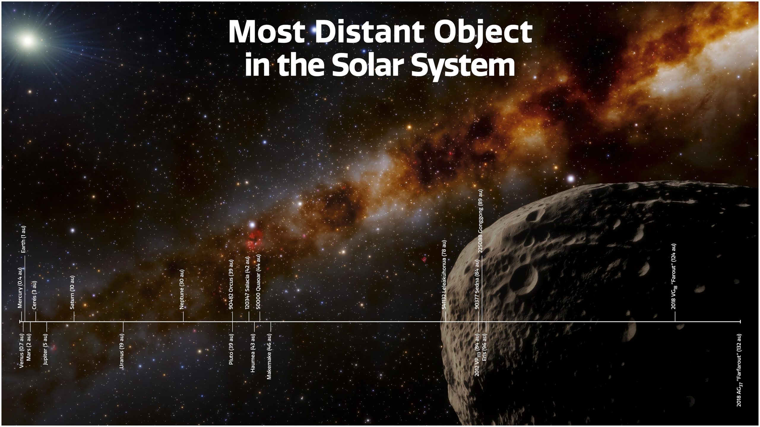
Determining accurate distances in the solar system requires a combination of geometric triangulation, radar ranging, and the precision timing of spacecraft telemetry. Because planetary orbits are elliptical and objects are in constant motion, distance is defined through a dynamic model rather than a fixed number, relying on the Astronomical Unit (AU) as the primary yardstick for interplanetary measurement.
The Foundation: The Astronomical Unit
The fundamental measurement used to navigate the solar system is the Astronomical Unit (AU). Historically defined as the average distance between the Earth and the Sun, the International Astronomical Union (IAU) redefined it in 2012 as an exact constant: 149,597,870,700 meters.
This standardization was necessary because the Earth’s orbit is not a perfect circle. As Earth travels along its elliptical path, the distance to the Sun fluctuates by approximately 5 million kilometers between perihelion (the point closest to the Sun) and aphelion (the point farthest away). By fixing the AU as a specific metric value, scientists removed the ambiguity inherent in using a variable planetary distance as a unit of measure. Today, the AU serves as the anchor point for all orbital mechanics and deep-space mission planning.
Geometric Triangulation and Parallax
The earliest methods for calculating distances within our neighborhood relied on parallax—the apparent shift of an object against a distant background when viewed from two different locations. By observing a planet from two separate points on Earth simultaneously, astronomers could use basic trigonometry to determine the distance to that object.
However, as the scale of the solar system expands beyond Mars, ground-based optical parallax becomes less effective due to the immense distances involved and the limits of angular resolution. In modern 2026 practice, this has been supplanted by high-precision astrometry. Missions like the ESA's Gaia, while focused on stellar distances, provide the foundational mapping framework that allows us to refine the positions of solar system bodies within the galactic coordinate system.
Radar Ranging and Time-Delay Measurements
For the planets and moons within our reach, the most accurate distance measurement technique is radar ranging. This involves bouncing radio signals off the surface of a target body and measuring the time it takes for the echo to return to Earth. Given that radio waves travel at the speed of light—a physical constant known with extreme precision—the distance can be calculated using the formula: distance equals the speed of light multiplied by half the round-trip travel time.
Radar ranging revolutionized planetary science in the mid-20th century, allowing researchers to pin down the distance to Venus and Mars with an accuracy that was previously impossible. Today, this method is supplemented by laser ranging, specifically retroreflectors placed on the Moon during the Apollo missions. By firing lasers at these reflectors and timing the return, we can measure the distance to the Moon with millimeter-level precision, tracking how the Moon is slowly spiraling away from Earth at a rate of approximately 3.8 centimeters per year.
Spacecraft Telemetry and the Deep Space Network
When dealing with the outer planets or objects beyond the reach of Earth-based radar, we rely on the Deep Space Network (DSN) and spacecraft telemetry. NASA’s DSN, a global network of large radio antennas, tracks spacecraft by measuring the doppler shift of their radio signals. By analyzing how these frequencies change, engineers can determine a spacecraft's velocity and radial distance from Earth with high accuracy.
Navigating to a planet like Jupiter or Saturn requires a "light-time" correction. Because light and radio signals take time to cross the void, what we see or track is always in the past. Mission controllers must calculate where a planet will be at the moment a signal reaches it, rather than where it appears to be at the moment the signal is sent. These complex orbital models are managed by the Jet Propulsion Laboratory's (JPL) HORIZONS system, which provides the most current ephemeris data—the coordinates of celestial bodies—for professional and amateur researchers alike.
Factors Affecting Measurement Accuracy
Several variables influence the precision of distance measurements in the solar system. Understanding these is essential for anyone interpreting astronomical data.
- Orbital Perturbations: Planets do not travel in perfect ellipses. The gravitational pull of other planets, the mass of the Sun, and even the pressure of solar radiation cause minor deviations in their paths.
- Relativistic Effects: As predicted by general relativity, gravity warps both space and time. Signals passing close to the Sun experience a "Shapiro delay," where the signal takes slightly longer to traverse the sun's gravitational field than it would in a flat spacetime.
- Measurement Noise: Instrumental error, atmospheric interference, and the physical shape of the planet (it is not a perfect sphere) can introduce small errors in radar ranging.
Comparison of Distance Measurement Techniques
| Method | Best Use Case | Primary Limitation |
|---|---|---|
| Radar Ranging | Inner planets, asteroids | Signal strength decays with distance |
| Laser Ranging | Lunar distance | Requires surface reflectors |
| Radio Telemetry | Active spacecraft | Limited to active transmitters |
| Astrometry | Relative planetary positions | Dependent on viewing geometry |
| Ephemeris Modeling | Long-term orbital prediction | Requires complex gravitational integration |
Practical Applications of Accurate Distances
Knowing these distances is not merely an academic exercise; it is a functional requirement for 2026-era space exploration. Precise distance data is critical for:
- Orbital Insertion: When a spacecraft approaches a target, failing to account for the exact distance can lead to the probe missing the planet entirely or burning up in its atmosphere.
- Communication Lag: Understanding distance allows ground crews to calculate the signal latency, which is essential for remote operations of rovers on Mars or probes in the outer solar system.
- Asteroid Impact Assessment: Tracking the exact distance and trajectory of Near-Earth Objects (NEOs) is the only way to predict potential collision risks.
Frequently Asked Questions
Why does the distance to planets change so drastically? Planets orbit the Sun at different speeds and at different distances. Because they all move in elliptical paths, they are sometimes on the same side of the Sun (opposition) and sometimes on opposite sides (conjunction). This creates a cycle of changing distances that dictates the best windows for space missions.
How do we know the distance to planets we haven't visited? We use Kepler's Third Law, which relates the orbital period of a planet to its distance from the Sun. By observing how long it takes a planet to complete an orbit, we can determine its semi-major axis, providing a very accurate distance model even without direct radar contact.
Is the "distance" measured to the surface or the center of a planet? In orbital mechanics, distances are usually calculated from the center of mass (barycenter). For missions that land on a surface, supplemental data—such as the planet's radius and topography—is added to the barycentric distance to determine the actual distance to the landing site.
Can I calculate these distances myself? Yes. Resources like NASA’s HORIZONS system are publicly accessible. You can input a date, a location on Earth, and a target planet to receive the exact, current distance based on the latest JPL ephemerides.
What is the "light-time" mentioned in mission reports? Light-time is the duration it takes for light or radio waves to travel between two points in space. Since nothing travels faster than light, this is the absolute minimum delay for any communication or observation. At Earth's average distance from the Sun, this is approximately 8 minutes and 20 seconds.
Next Steps for Precise Observation
If you are looking to utilize accurate distance data for your own projects, the recommended first step is to familiarize yourself with the JPL HORIZONS web interface. It serves as the industry standard for generating ephemerides. For those interested in the physics behind these measurements, the Explanatory Supplement to the Astronomical Almanac remains the definitive text for understanding the conversion of coordinates and the application of relativistic time corrections in solar system navigation.