Africa’s rainfall patterns are primarily driven by the movement of the Intertropical Convergence Zone (ITCZ) and modulated by global climate drivers like El Niño and the Indian Ocean Dipole. These patterns vary from hyper-arid deserts to equatorial rainforests. Because much of the continent depends on rain-fed agriculture, shifts in timing or intensity directly influence food security, economic stability, and public health across the region.
The Mechanisms Driving African Rainfall
To understand the diversity of African climates, one must first examine the atmospheric engines that dictate when and where water falls. Unlike temperate regions governed by frontal systems, African rainfall is largely a product of tropical dynamics and moisture transport from the surrounding oceans.
The Intertropical Convergence Zone (ITCZ)
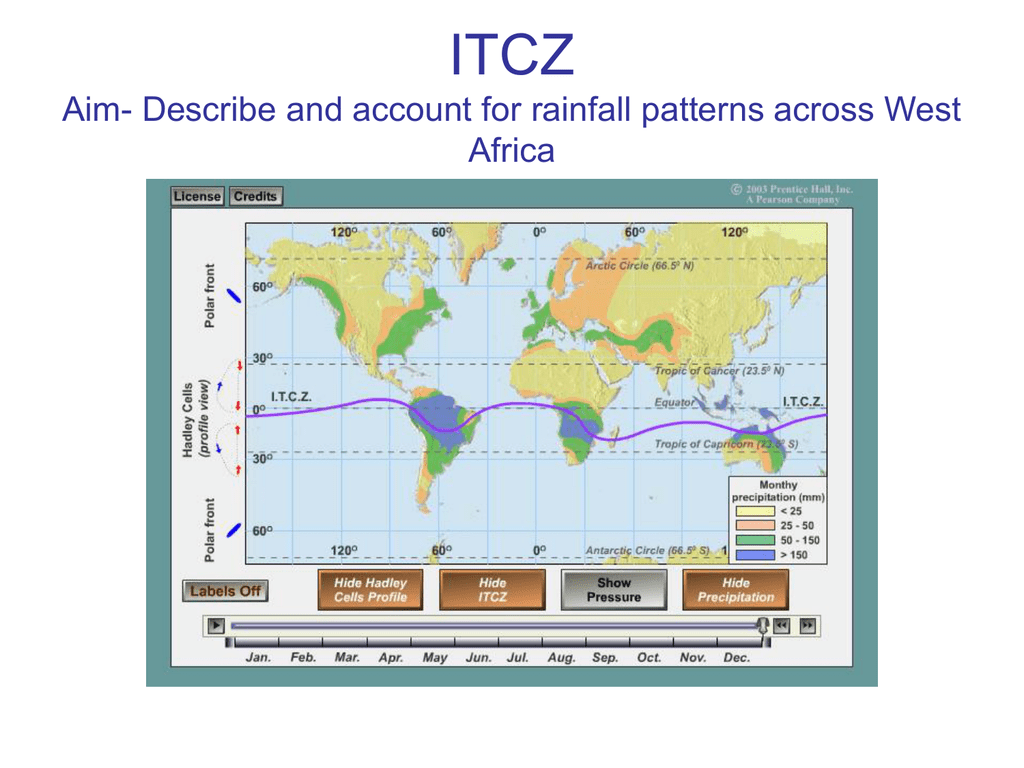
The Intertropical Convergence Zone (ITCZ) is the most significant driver of seasonality in Africa. This low-pressure belt, where the trade winds from the Northern and Southern Hemispheres meet, follows the sun's zenith. As the sun moves between the Tropics of Cancer and Capricorn, the ITCZ shifts accordingly, bringing a "monsoonal" belt of rain. In the equatorial regions, this results in two distinct rainy seasons as the ITCZ passes over twice a year. Further north or south, these merge into a single summer rainy season.
The West African Monsoon (WAM)
The West African Monsoon is a complex system of wind and moisture that defines the life cycles of millions in the Sahel and Guinea Coast. During the boreal summer, the thermal heating of the Saharan landmass creates a low-pressure zone that draws moist air from the Atlantic Ocean into the continent. The strength and penetration of this monsoon are influenced by sea-surface temperatures in the Gulf of Guinea and the positioning of the African Easterly Jet (AEJ).
Global Teleconnections: ENSO and IOD
African rainfall is not an isolated system; it is deeply connected to global ocean-atmosphere cycles.
- El Niño-Southern Oscillation (ENSO): During El Niño years, Southern Africa typically experiences severe droughts, while parts of East Africa often see increased rainfall and flooding.
- Indian Ocean Dipole (IOD): A "positive" IOD involves warmer-than-average sea surface temperatures in the western Indian Ocean. This often leads to devastating floods in East Africa, as seen in historical events and more recent cycles leading up to 2026.
Regional Rainfall Characteristics
The African continent is geographically vast, resulting in distinct climatic zones with varying degrees of water availability.
North Africa and the Sahara
The northern tier of the continent is dominated by the Sahara Desert, the largest hot desert in the world. Rainfall here is sporadic and often negligible, except for the Mediterranean fringe. In countries like Morocco, Algeria, and Tunisia, rainfall occurs primarily in the winter months due to mid-latitude cyclones. These regions are increasingly reliant on groundwater and desalination as the "winter rain belt" shows signs of shifting poleward.
West Africa
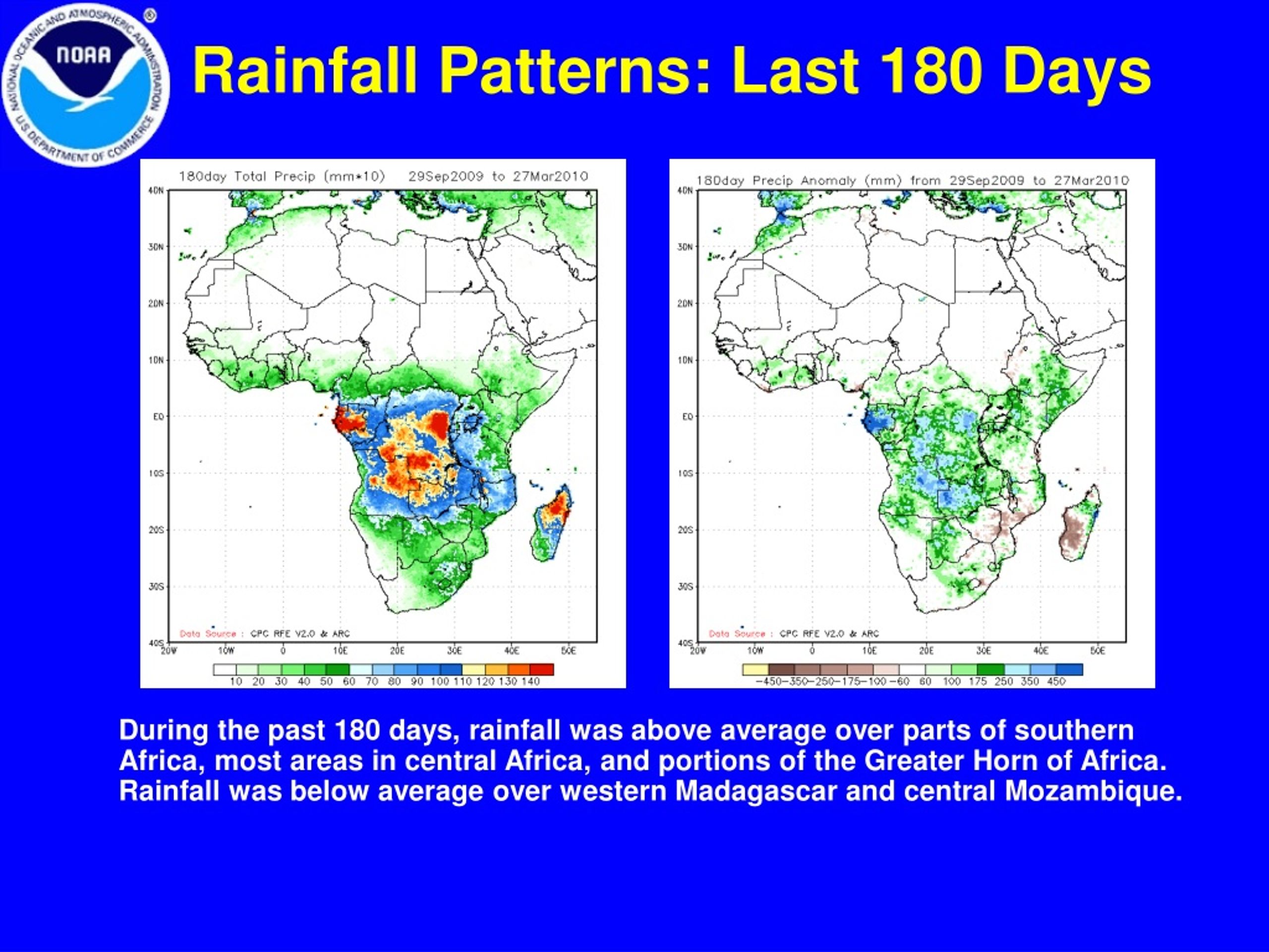
West Africa exhibits a sharp moisture gradient. The southern coastal areas (e.g., Nigeria, Ghana, Ivory Coast) experience high annual rainfall exceeding 2,000mm in some areas, supporting dense tropical forests. Moving north into the Sahel, rainfall drops significantly to between 200mm and 600mm annually, occurring in a brief window from July to September. This makes the Sahel one of the most climate-vulnerable regions on Earth.
Central Africa (The Congo Basin)
Central Africa is the continent’s "green heart." The Congo Basin receives consistent, heavy rainfall year-round, often exceeding 3,000mm in the wettest parts. This is driven by intense convective activity and high rates of evapotranspiration, where the dense forest effectively "recycles" its own moisture, contributing to rainfall even during periods when the ITCZ has moved away.
East Africa and the Horn
East Africa’s rainfall is uniquely bimodal. The "Long Rains" typically occur from March to May, while the "Short Rains" run from October to December. The topography of the Great Rift Valley creates localized microclimates, where highland areas receive significantly more moisture than the surrounding arid lowlands of Somalia and eastern Ethiopia.
Southern Africa
Southern Africa features a mix of humid subtropical climates in the east and arid/semi-arid conditions in the west (the Kalahari and Namib deserts). Most of the region receives rainfall during the austral summer (November to March). However, the Western Cape of South Africa is a notable exception, possessing a Mediterranean climate with winter rainfall.
| Region | Primary Rainy Season | Major Drivers | Average Annual Rainfall (Range) |
|---|---|---|---|
| North Africa | November – March | Mediterranean Cyclones | 50mm – 600mm |
| West Africa (Sahel) | July – September | West African Monsoon | 200mm – 800mm |
| Central Africa | Year-round | Convection / ITCZ | 1,500mm – 3,000mm+ |
| East Africa | Mar-May & Oct-Dec | ITCZ / Indian Ocean Dipole | 400mm – 1,200mm |
| Southern Africa | November – March | Tropical Temperate Troughs | 200mm – 1,000mm |
Socio-Economic Impacts of Rainfall Variability
Rainfall is the lifeblood of African economies. In 2026, the correlation between precipitation patterns and National GDP remains one of the highest in the world due to the structure of the continent's labor market and resource dependence.
Agriculture and Food Security
Approximately 80% of sub-Saharan African agriculture is rain-fed. Unlike parts of Asia or the Americas where large-scale irrigation is common, African farmers rely on the predictable arrival of seasonal rains.
- Delayed Onset: If the rains arrive two weeks late, it can lead to total crop failure for staples like maize, which have specific germination windows.
- Intense Rainfall: Conversely, extreme downpours lead to soil erosion and nutrient leaching, stripping the land of its productivity.
- Pastoralism: In arid regions, rainfall determines the availability of grazing land. Variations in rain often trigger migration and, in some cases, conflict over dwindling water points.
Water Resources and Hydropower
Africa’s energy transition relies heavily on hydropower. Projects like the Grand Ethiopian Renaissance Dam (GERD) and the Inga Dams in the Congo rely on consistent river flow, which is entirely dependent on rainfall in the respective highland catchment areas. Droughts in the Zambezi basin have historically led to massive power outages in Zambia and Zimbabwe, highlighting the vulnerability of "clean energy" to climate fluctuations.
Public Health and Disease Dynamics
Rainfall patterns are a primary determinant of vector-borne and water-borne diseases.
- Malaria: Increased rainfall creates standing water, which serves as breeding grounds for Anopheles mosquitoes.
- Cholera: Massive flooding events often compromise sanitation infrastructure, leading to outbreaks of cholera and other diarrheal diseases.
- Meningitis: In the "Meningitis Belt" of the Sahel, the arrival of the rains usually signals the end of the dry, dusty season that facilitates the spread of bacterial meningitis.
Urban Infrastructure and Displacement
As of 2026, Africa is experiencing the fastest rate of urbanization globally. However, many cities lack adequate drainage systems. Extreme rainfall events lead to "flash floods" in informal settlements, destroying homes and displacing thousands. These "climate refugees" often move from rural areas to cities after successive droughts, only to find themselves at risk of flooding in urban environments.
Current Trends and Future Outlook in 2026
The year 2026 marks a critical juncture in African climate policy. Observations over the last decade indicate that while some parts of the continent are becoming wetter, the rainfall is becoming more erratic.
The "Dryer gets Drier, Wetter gets Wetter" Paradigm
Recent data from the Intergovernmental Panel on Climate Change (IPCC) suggests that Northern and Southern Africa are seeing a long-term drying trend. Meanwhile, Central and parts of East Africa are seeing an increase in total annual rainfall. However, this "increased" rainfall often comes in the form of extreme storms rather than gentle, soaking rains, which reduces its utility for agriculture.
Technological and Policy Responses
By 2026, several initiatives have gained momentum to mitigate these impacts:
- Early Warning Systems: The World Meteorological Organization (WMO) has prioritized the "Early Warnings for All" initiative in Africa, using satellite data to provide farmers with localized weather forecasts via SMS.
- Climate-Smart Agriculture: Promotion of drought-resistant crop varieties, such as specific strains of sorghum and millet, is helping stabilize food supplies in the Sahel.
- Great Green Wall: This ambitious project to plant a belt of trees across the Sahel aims to modify local microclimates and increase soil moisture retention.
Frequently Asked Questions
Which part of Africa receives the most rainfall?
The Congo Basin and the coastal regions of West Africa (such as parts of Sierra Leone and Liberia) are the wettest. Specifically, Debundscha in Cameroon is frequently cited as one of the wettest places on Earth, receiving over 10,000mm of rain annually due to orographic lifting as moist air hits Mount Cameroon.
How does El Niño affect rainfall in East Africa?
Unlike Southern Africa which experiences drought, El Niño typically brings above-average rainfall to East Africa. While this can sometimes benefit agriculture, it frequently leads to catastrophic flooding, landslides, and the destruction of infrastructure.
Why is the Sahel so vulnerable to rainfall changes?
The Sahel exists on a knife-edge between the Sahara Desert and the tropical forests. Its ecosystem is highly sensitive to the West African Monsoon. Because the rainy season is so short, a failure of just a few weeks of rain can mean a total loss of the year's food supply.
What is "bimodal" rainfall?
Bimodal rainfall refers to a region having two distinct rainy seasons in a single year. This is common near the equator (like in Kenya and Uganda), where the ITCZ passes over the region twice—once moving north and once moving south.
Can reforestation increase rainfall in Africa?
Yes, through a process called moisture recycling. Forests release water vapor through their leaves (transpiration). This vapor contributes to the formation of clouds and subsequent rainfall downwind. Large-scale reforestation, like the Great Green Wall, aims to leverage this biological process.
Practical Recommendations for 2026 and Beyond
For policymakers, non-governmental organizations, and residents, addressing the impacts of African rainfall patterns requires a multi-faceted approach:
- Invest in Data: Strengthen national meteorological agencies to move beyond generic forecasts to "impact-based" forecasting.
- Infrastructure Resilience: Urban planning must prioritize permeable surfaces and robust drainage to handle the increasing frequency of "once-in-a-century" flood events.
- Diversification: Farmers should be encouraged to diversify crops and integrate livestock, which can act as a financial buffer during low-rainfall years.
- Regional Cooperation: Since river basins (like the Nile, Niger, and Zambezi) cross multiple borders, transboundary water management agreements are essential to prevent conflict during periods of water scarcity.
Effective management of Africa’s water future depends on a deep respect for the continent's natural cycles and the integration of traditional knowledge with modern climate science.