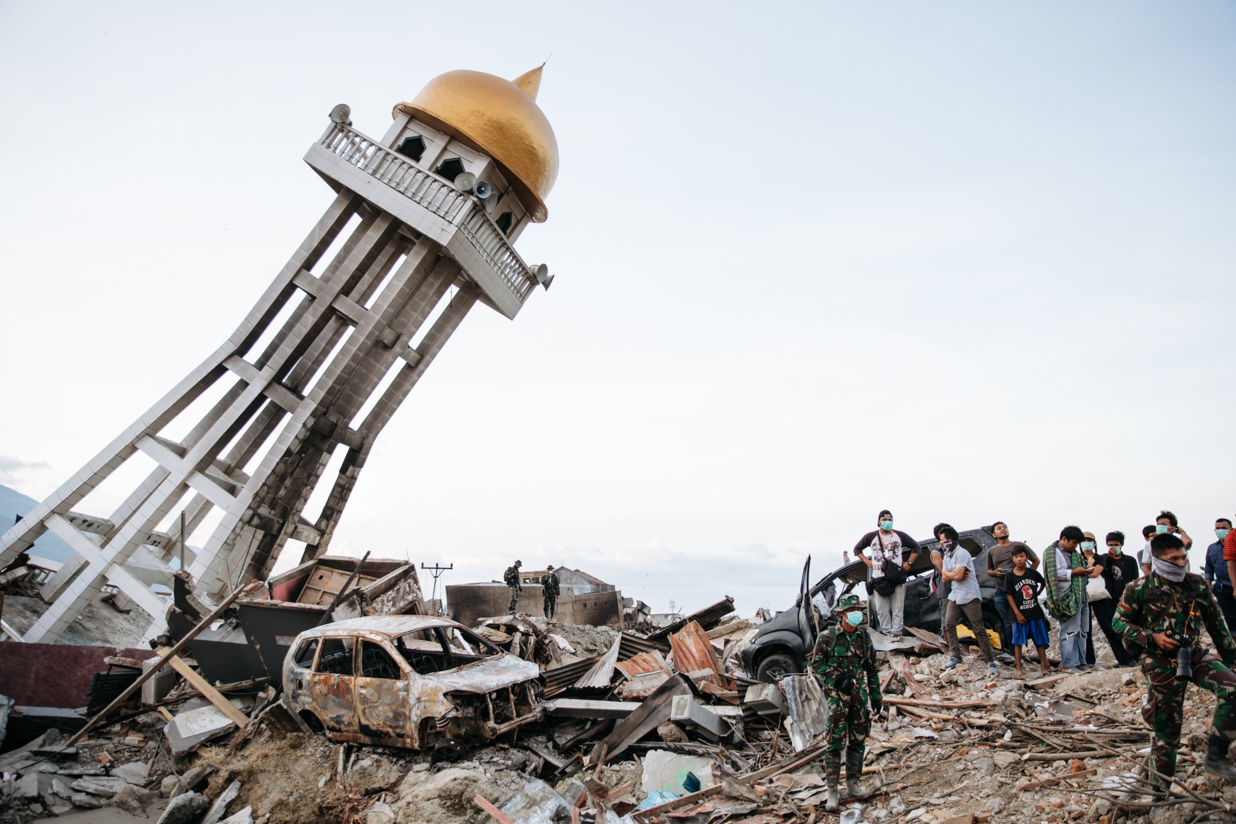
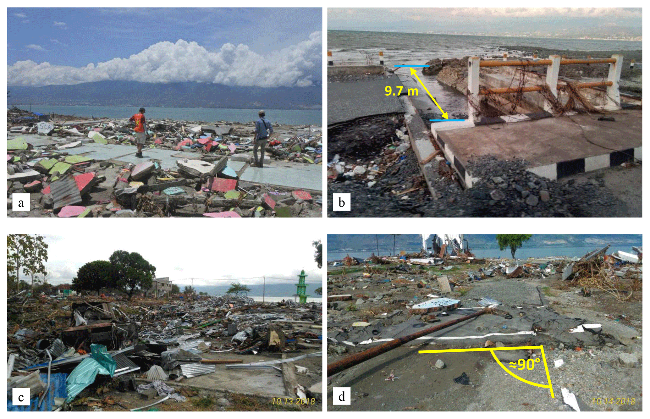
On September 28, 2018, a magnitude 7.5 earthquake struck Central Sulawesi, Indonesia, triggering devastating localized tsunamis and massive soil liquefaction. The event destroyed broad sections of Palu and neighboring districts, resulting in over 4,300 deaths and fundamentally altering scientific understanding of tsunami hazards generated by strike-slip fault systems.
Chronology and Tectonic Setting of the Disaster
The earthquake occurred at 18:02 local time (10:02 UTC) on September 28, 2018, with its epicenter located on the Minahasa Peninsula, approximately 78 kilometers north of the provincial capital of Palu. The mainshock measured $M_w$ 7.5 at a shallow depth of roughly 20 kilometers, following a sequence of foreshocks that had begun earlier in the day, including a magnitude 6.1 event at 15:00 local time that caused minor structural damage and initial casualties.
- [ Sulawesi Sea ]
- Epicenter (Mw 7.5, 18:02 WITA)
- [ Palu Bay ] (Tsunami Wave Funneling)
- Palu City Center (Petobo & Balaroa Liquefaction)
- Palu-Koro Fault Zone
Sulawesi sits within a highly complex tectonic collision zone where the Sunda plate, the Australian plate, the Pacific plate, and the Philippine Sea plate interact. The primary geological driver of the 2018 event was the Palu-Koro fault system, a major left-lateral strike-slip fault traversing Central Sulawesi from north-northwest to south-southeast. The fault exhibits high slip rates, estimated between 30 and 40 millimeters per year, making it one of the most active strike-slip features in the region.
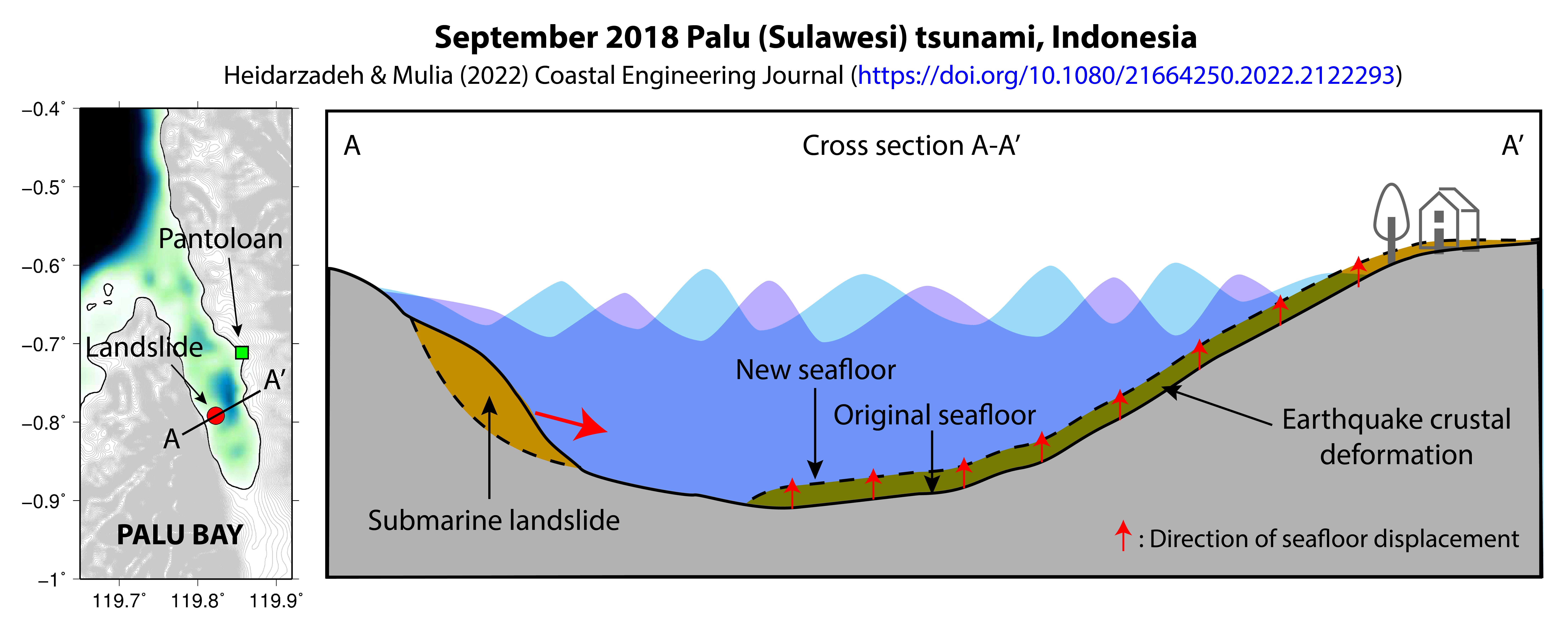
Shallow strike-slip earthquakes typically displace ground horizontally rather than vertically. Because vertical displacement of the seafloor is the classical mechanism for displacing large water columns, international early warning systems did not initially project a massive, ocean-crossing tsunami. However, within minutes of the main rupture, localized tsunami waves struck the narrow, deep bay of Palu, catching coastal populations unprepared.
The Tsunami Mechanism: Anomalous Hazards from Strike-Slip Ruptures
The 2018 tsunami generated waves that reached run-up heights exceeding 4 to 7 meters along the coastline of Palu Bay, with localized measurements recording run-ups up to 10 meters. The arrival time of the waves was exceptionally fast, striking coastal communities within 2 to 5 minutes after the primary earthquake shaking ceased.
Scientists and seismologists investigated how a strike-slip rupture produced such destructive wave energy. Research published in international journals, including studies indexed by the United States Geological Survey (USGS), points to a dual mechanism:
Submarine and Coastal Landslides: Ground displacement caused massive coastal and underwater landslides along the steep slopes of Palu Bay. The sudden movement of dense sediment into the deep bay waters displaced large volumes of liquid, generating high-frequency, energetic local tsunami waves.
Dynamic Tectonic Displacement and Bay Amplification: The geometry of Palu Bay acted as a physical funnel. As tsunami waves traveled southward into the narrowing, shallowing bay, their amplitude increased dramatically, concentrating destructive kinetic energy directly toward downtown Palu.
Landslide / Tectonic Displacement
Narrow Bay Geometry
Wave Energy Funneling
Extreme Local Run-up (Up to 10m)
Furthermore, advanced seismic analysis revealed that the earthquake was a supershear rupture—a rare seismic event where the fault rupture propagates faster than the speed of seismic shear waves ($S$-waves). Supershear ruptures concentrate high levels of seismic energy along the fault line, intensifying ground shaking along the rupture path and triggering catastrophic secondary ground failures.
Massive Soil Liquefaction: The Destruction of Petobo and Balaroa
Beyond coastal wave impacts, the earthquake caused some of the severe instances of lateral spreading and flow liquefaction recorded in modern engineering history. Soil liquefaction occurs when saturated, loose granular soil loses its shear strength in response to intense, sustained ground shaking, behaving temporarily like a dense liquid.
- Saturated Sand/Silt + High Water Table + Sustained Shaking (Supershear)
- Pore Water Pressure Spikes
- Complete Loss of Shear Strength (Liquid Behavior)
The hydrogeological conditions of the Palu Valley created an extreme vulnerability to liquefaction:
- Unconsolidated Alluvial Sediments: The valley floor consists of thick layers of young, loose river sediment washed down from surrounding mountain ranges.
- Unconfined Aquifers and Irrigation: An extensive network of unlined irrigation canals, notably the Gumbasa Irrigation Canal, maintained high water-table levels near the surface adjacent to agricultural and urban developments.
When the $M_w$ 7.5 strike-slip quake ruptured, pore water pressure within the saturated sand and silt layers spiked dramatically, neutralizing effective stress between soil grains. Entire landmasses liquefying beneath residential settlements caused large-scale ground displacement:
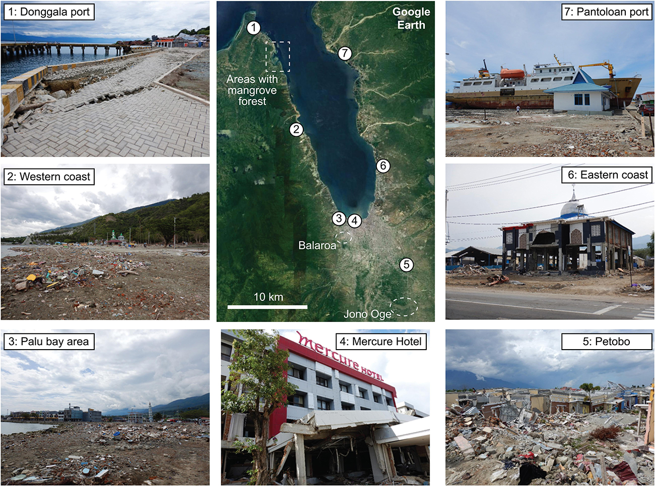
- Petobo: A suburban area southeast of Palu experienced massive flow slides. The ground transformed into a moving mudflow, liquidizing several meters deep. The mud displaced thousands of residential structures, dragging homes hundreds of meters from their foundations and submerging entire neighborhoods.
- Balaroa: Located along a sloping margin near the fault trace, Balaroa suffered massive structural subsidence and lateral spreading. The underlying soil liquefied and buckled, causing the ground surface to collapse downward and slide laterally, crushing buildings under displaced layers of earth.
- Jono Oge and Sibalaya: Agricultural zones south of Palu saw large tracts of farmland slide laterally over distances exceeding one kilometer, shifting roads, coconut groves, and residential compounds entirely out of alignment.
Warning Systems, Emergency Response, and Immediate Challenges
The disaster highlighted vulnerabilities in multi-hazard early warning architecture, post-disaster telecommunications, and immediate emergency logistics.
Early Warning System Limitations
Indonesia’s national early warning agency, the Indonesian Agency for Meteorology, Climatology, and Geophysics (BMKG), issued a tsunami warning immediately after detecting the $M_w$ 7.5 event. However, structural and operational limitations delayed crisis response:
- Sensor Infrastructure: The coastal tide-gauge and ocean-buoy detection network suffered from maintenance gaps and missing deep-ocean sensors. The nearest functioning tide gauge was far from Palu Bay and failed to capture the instantaneous wave generation caused by local landslides.
- Communications Breakdown: The severe shaking severed regional power lines and collapsed telecommunications towers across Central Sulawesi. As a result, early warning SMS alerts and siren triggers failed to reach residents along the shoreline before the first waves hit.
- Cancellation Timing: The initial tsunami alert was canceled approximately 30 minutes after the earthquake based on standard operational protocols when distant tide gauges showed non-catastrophic sea-level changes. However, by that time, the localized waves inside Palu Bay had already completed their destruction.
Emergency Logistics and Relief Bottlenecks
Disaster response efforts faced severe logistical bottlenecks during the first 72 hours:
- Airfield Disruptions: Palu’s Mutiara SIS Al-Jufrie Airport suffered runway cracking and control tower damage, restricting air traffic to specialized military transport aircraft.
- Land Access Blockades: Main supply roads connecting Palu to surrounding provinces were blocked by landslides, ground fissures, and collapsed bridges, delaying heavy machinery, medical teams, and emergency fuel supplies.
- Search and Rescue Operations: National disaster agencies, including the Indonesian National Board for Disaster Management (BNPB) and the National Search and Rescue Agency (BASARNAS), struggled to clear liquefied soil in Petobo and Balaroa. Traditional urban search-and-rescue protocols were ineffective in deep, quicksand-like mud, forcing responders to wait for heavy earth-moving machinery to stabilize access paths.
Key Technical Parameters and Event Data
The following table summarizes the verified scientific parameters, geophysical metrics, and impact statistics of the 2018 event, compiled from reports by the USGS Earthquakes Program and official casualty reports from BNPB.
| Parameter / Metric | Verified Data |
|---|---|
| Date and Local Time | September 28, 2018, 18:02 WITA (10:02:43 UTC) |
| Moment Magnitude ($M_w$) | 7.5 |
| Focal Depth | 20.0 km (Shallow faulting) |
| Epicentral Coordinates | 0.256° S, 119.840° E |
| Primary Fault System | Palu-Koro Fault (Left-lateral strike-slip mechanism) |
| Maximum Seismic Intensity | MMI IX (Violent shaking in Palu and Donggala) |
| Rupture Speed Category | Supershear rupture (~4.1 km/s propagation velocity) |
| Tsunami Height Ranges | 4.0 to 7.0 meters average; localized run-ups up to 10.7 meters |
| Primary Tsunami Trigger | Combination of strike-slip coastal displacement and submarine landslides |
| Fatalities (Confirmed & Presumed) | 4,340+ (Including bodies recovered and those missing in liquefaction zones) |
| Major Liquefaction Sites | Petobo, Balaroa, Jono Oge, Sibalaya |
| Internally Displaced Persons (IDPs) | Exceeded 170,000 to 200,000 individuals |
Economic Damage, Reconstruction, and Regional Policy Shifts
The total economic damage and losses from the disaster were estimated by the World Bank and Indonesian government agencies at approximately IDR 18.48 trillion (roughly USD 1.3 billion at 2018 exchange rates). Infrastructure losses spanned private housing, transportation corridors, agricultural irrigation, ports, and municipal utilities.
- Primary Economic Impact (Housing, Roads, Ports)
- Estimated IDR 18.48 Trillion Loss
- Policy Response: Hazard Zoning + Red Zone Enforcements (ZRB) + Pipe Infrastructure Upgrades
- Estimated IDR 18.48 Trillion Loss
Land-Use Redefinition: Red Zones (Zona Rawan Bencana)
Following the event, the Indonesian government, led by the Ministry of Public Works and Public Housing (PUPR) alongside spatial planning authorities, updated regional land-use guidelines. Large sections of Petobo, Balaroa, and vulnerable coastal strips along Palu Bay were classified as ZRB IV (Red Zones)—areas designated as too hazardous for permanent residential settlement due to high flow-liquefaction risk or acute tsunami susceptibility.
- [Zone Classification System (ZRB)]
- ZRB I (Low Risk) -- Standard Development Allowed
- ZRB II (Moderate) -- Conditional Building Codes (Reinforced Concrete)
- ZRB III (High Risk) -- Strict Infrastructure Controls / Retrofitting Required
- ZRB IV (Red Zone) -- Non-Buildable Area (Parks, Green Belts, Memorials)
Relocation and Housing Infrastructure
Thousands of affected families were transitioned from temporary shelters (huntara) into permanent resettlement housing (huntap) constructed on safer elevated terrain inland, such as Duyu, Tondo, and Pobooya. The construction incorporated earthquake-resistant design standards specified under revised Indonesian structural building codes (SNI 1726:2019).
Hydrogeological and Geotechnical Remediation
To mitigate future liquefaction risk, structural engineers modernized the damaged Gumbasa Canal network. Design modifications included:
- Converting unlined, permeable soil-bottom canals into concrete-lined conduits to reduce subsurface seepage into surrounding water tables.
- Installing subsurface drainage networks to control pore water pressure in urbanized alluvial fans.
- Establishing strict groundwater extraction guidelines to stabilize regional water tables.
Early Warning and Mitigation Infrastructure
The 2018 event catalyzed structural changes in global geophysics research and national hazard warning protocols.
Integration of Multi-Sensor Warning Networks
The failure of traditional distant sea-level monitors to detect localized landslide tsunamis led international bodies, such as the Intergovernmental Oceanographic Commission of UNESCO (UNESCO-IOC), to upgrade warning architectures in semi-enclosed bays and strike-slip coastal zones.
Standard seismic monitoring is now combined with real-time GNSS (Global Navigation Satellite System) stations along fault lines to estimate ground displacement within seconds of an event. Additionally, high-resolution coastal radar and subsea pressure gauges have been installed in high-risk coastal zones across Indonesia to catch rapid, landslide-driven water displacement.
- Seismic Array + Real-Time GNSS Displacement
- Rapid Finite-Fault Modeling
- Localized Tsunami Alert (< 3 min)
Community-Based Hazard Preparedness
The short arrival time (2 to 5 minutes) of the Palu Bay tsunami highlighted the limitations of centralized warning systems during near-field events. Disaster management frameworks now emphasize natural warnings: educating coastal populations to evacuate immediately inland or to higher ground upon experiencing strong ground shaking, without waiting for official siren broadcasts or SMS updates.
Frequently Asked Questions
Why was the 2018 Palu tsunami unexpected by standard warning models?
Standard tsunami early warning protocols are built primarily around subduction zone earthquakes, where thrust-faulting moves the seafloor vertically to displace water columns. Because the 2018 Sulawesi event occurred along a horizontal strike-slip fault, primary models did not project major tsunami formation. The resulting tsunami was generated primarily by secondary coastal and submarine landslides, coupled with the funneling effect of Palu Bay, which standard automated systems were not configured to process instantly.
What is flow liquefaction, and why was it so severe in Central Sulawesi?
Flow liquefaction is an extreme form of ground failure where saturated, uncompacted sandy or silty soil completely loses its strength during shaking and behaves like a fluid. In areas like Petobo and Balaroa, high water tables—amplified by unlined irrigation canals—combined with loose alluvial soil layers and steep underlying topography. When the strike-slip earthquake struck, intense ground shaking caused pore water pressure to spike, causing soil layers to liquefy and flow downstream.
How many casualties were caused by the 2018 Sulawesi earthquake and tsunami?
Official reports from the Indonesian National Board for Disaster Management (BNPB) confirm over 4,340 fatalities. This total includes recovered bodies and thousands of individuals who were declared missing and presumed dead after being buried beneath deep liquefied soil in Petobo and Balaroa or swept out to sea by the tsunami waves.
What was the magnitude and depth of the main event?
The main earthquake measured a moment magnitude ($M_w$) of 7.5 at a shallow depth of approximately 20 kilometers. The shallow epicenter concentrated destructive ground motion along the surface trace of the Palu-Koro fault system.
How has urban planning in Palu changed following the disaster?
Indonesian authorities enacted spatial planning policies that designated the worst-affected liquefaction zones and vulnerable shorelines as Red Zones (Zona Rawan Bencana IV). Resettlement programs moved displaced residents into newly built, earthquake-resistant permanent housing (huntap) located on ground away from known fault traces and liquefaction-prone alluvial fans.
Disaster Risk Reduction: Lessons and Practical Action
The 2018 Sulawesi earthquake and tsunami highlighted critical vulnerabilities in coastal planning, geotechnical assessment, and emergency communications. For municipal authorities, urban planners, and communities operating in tectonically active regions, the event highlights several technical requirements:
- Mandate Geotechnical Soil Hazard Studies: Urban expansion in alluvial valleys must include mandatory soil-liquefaction risk mapping, dynamic pore-pressure testing, and microzonation studies prior to zoning approval.
- Implement Structural Controls on Irrigation: Unlined surface canals should not run parallel to uncompacted, sloping residential zones. Converting open-earth canals to sealed, concrete-lined pipes prevents artificial artificial elevated water tables in urbanized areas.
- Prioritize Self-Evacuation Protocols: In near-field coastal environments near strike-slip or local subduction faults, populations must be trained to recognize violent shaking as an immediate natural tsunami warning. Evacuation to high ground must occur immediately without waiting for automated network alerts.
- Adopt Red-Zone Enforcements: Post-disaster recovery requires enforcing non-buildable buffers around active fault traces, landslide-prone slopes, and low-lying bay shorelines to prevent repeat casualties during future seismic cycles.