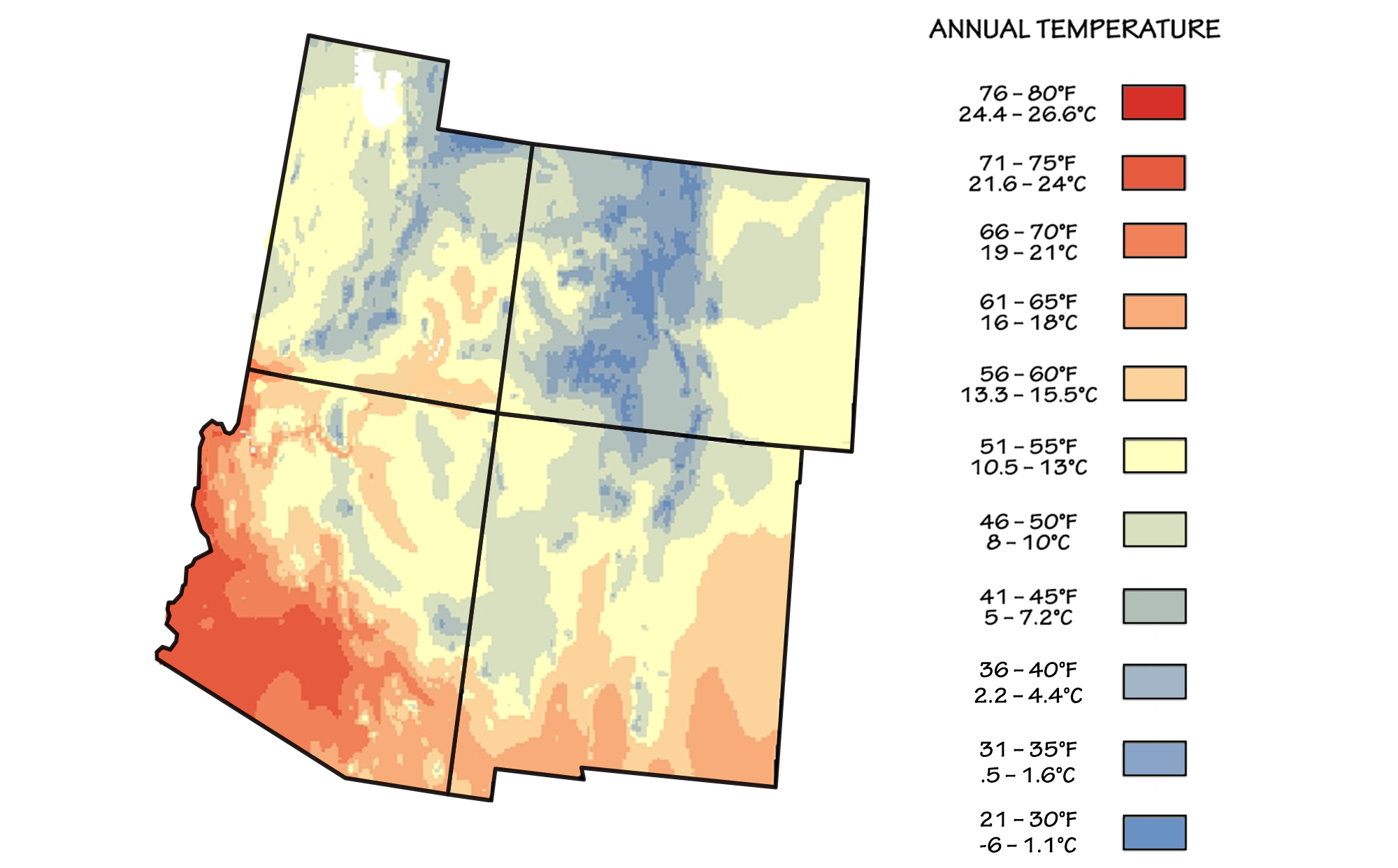
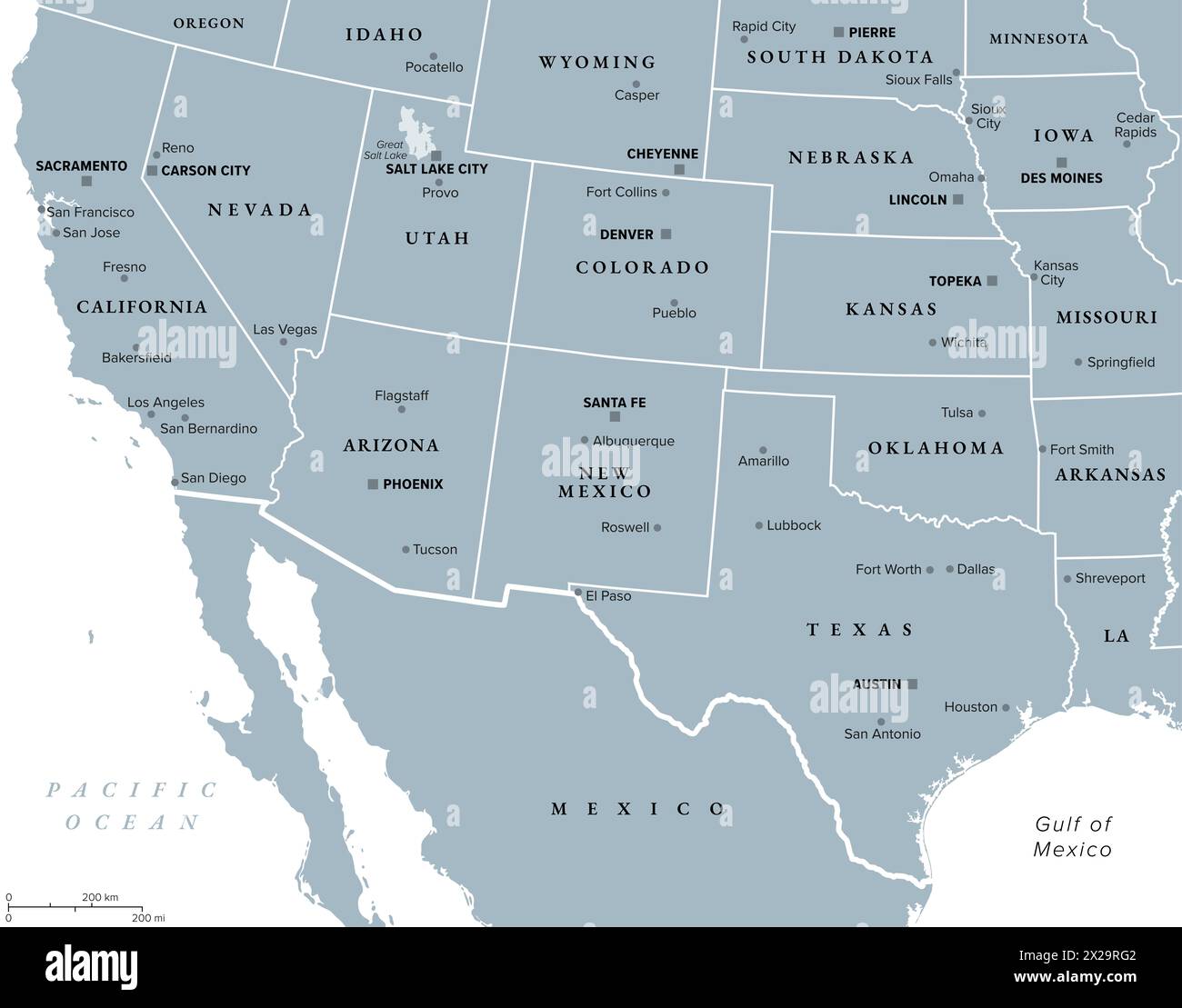
Arizona is located in the Southwestern United States, positioned as a landlocked state within the Mountain West subregion. It is bordered by Utah to the north, New Mexico to the east, Nevada to the northwest, California to the west, and the Mexican states of Sonora and Baja California to the south.
As of 2026, Arizona continues to be a focal point of American demographic and economic shifts, largely due to its unique geographic positioning. Known primarily for its arid climates and the iconic Grand Canyon, the state serves as a critical bridge between the Pacific Coast and the interior United States. Its location is defined not just by political borders but by a complex interplay of high-altitude plateaus, low-lying deserts, and vital river systems that dictate the lifestyle and industry of the region.
The Geographic Coordinates and Physical Boundaries of Arizona
Arizona spans approximately 113,990 square miles, making it the sixth-largest state in the Union. Its absolute location is roughly between 31° and 37° North latitude and 109° and 114° West longitude. This latitudinal placement puts the state squarely within the subtropics, contributing to the extreme heat found in its southern valleys, while its longitudinal span places it deep within the North American Cordillera.
The state’s boundaries are a mix of straight-line political demarcations and natural features. The western border is primarily defined by the path of the Colorado River, separating Arizona from California and Nevada. To the south, the international boundary with Mexico extends for 389 miles, a corridor that is central to North American trade and migration patterns in 2026. To the north and east, the borders are geometric lines established during the territorial era of the 19th century.
The Four Corners: A National Geographic Landmark
Arizona is a member of the "Four Corners," the only location in the United States where four states meet at a single point. This intersection includes Arizona, Utah, Colorado, and New Mexico. Located on the Navajo Nation, the Four Corners Monument marks the northeastern apex of the state. This specific geographic curiosity underscores Arizona's connectivity to the Intermountain West and its shared cultural and geological history with the Rocky Mountain states.
The Topographic Divide: Basin and Range vs. The Colorado Plateau
One of the most defining characteristics of Arizona's location is its split topography. The state is effectively divided into two distinct physiographic provinces by the Mogollon Rim, a massive escarpment that runs diagonally across the center of the state.
The Colorado Plateau (Northern Arizona)
The northern half of Arizona sits atop the Colorado Plateau. This is a high-altitude region characterized by horizontal rock layers, deep canyons, and vast coniferous forests. Because of its elevation (often exceeding 5,000 to 7,000 feet), this part of the state experiences a much cooler climate than the south. It is home to the Grand Canyon, a geological marvel carved by the Colorado River, which serves as a primary drainage system for the entire Southwestern United States.
The Basin and Range Province (Southern and Western Arizona)
Moving south of the Mogollon Rim, the landscape shifts dramatically into the Basin and Range Province. This area consists of abrupt, needle-like mountain ranges separated by broad, flat desert basins. This is where the famous Sonoran Desert is located, housing the state’s major metropolitan hubs, Phoenix and Tucson. In 2026, these basins continue to face the challenges of urban heat islands, a direct consequence of their low elevation and geographic bowl-like structures that trap warm air.
The Transition Zone
Between these two major provinces lies the Transition Zone. This area is characterized by rugged mountains and canyons that are more geologically complex than the plateau but lack the wide basins of the south. This zone is rich in mineral deposits, particularly copper, which historically earned Arizona the nickname "The Copper State."
International and Interstate Relations: The Southern Corridor
Arizona's location on the U.S.-Mexico border is a cornerstone of its identity and economy. The southern boundary connects Arizona to Sonora, Mexico, through major ports of entry like Nogales, Douglas, and San Luis. In 2026, these ports remain vital for the "just-in-time" supply chains of the automotive and aerospace industries.
Proximity to California is another defining factor of its location. Arizona serves as a primary bypass for goods traveling from the Ports of Los Angeles and Long Beach to the rest of the United States. The Interstate 10 and Interstate 40 corridors are the lifelines of this logistics network. However, this proximity also means Arizona is influenced by California’s economic trends, leading to the "Silicon Desert" phenomenon where tech companies migrate from the coast to the more affordable Phoenix and Chandler areas.
Time Zone Anomalies: The MST Advantage in Arizona
A unique aspect of Arizona’s geographic and administrative location is its relationship with time. While most of the United States observes Daylight Saving Time (DST), Arizona remains on Mountain Standard Time (MST) year-round. This policy was solidified under the Uniform Time Act of 1966, with Arizona opting out in 1968 to save energy and avoid extending summer daylight hours into the late evening, which would increase cooling costs in the desert heat.
The only exception within the state is the Navajo Nation in northeastern Arizona, which does observe DST to maintain consistency with its tribal lands in Utah and New Mexico. Conversely, the Hopi Reservation, which is entirely surrounded by the Navajo Nation, does not observe DST. This creates a "time island" effect that is unique in the Western Hemisphere, requiring careful planning for travelers and logistics coordinators moving through the region in 2026.
| Feature | Northern Arizona (Plateau) | Southern Arizona (Basin/Range) |
|---|---|---|
| Primary Climate | Highland/Semi-arid | Arid/Desert |
| Elevation Range | 5,000 - 12,000+ ft | 500 - 4,000 ft |
| Key Cities | Flagstaff, Page, Winslow | Phoenix, Tucson, Yuma |
| Major Landmarks | Grand Canyon, San Francisco Peaks | Saguaro National Park, Superstition Mts |
| Primary Vegetation | Ponderosa Pine, Juniper | Saguaro Cactus, Creosote |
| Economic Drivers | Tourism, Forestry, Education | Tech, Aerospace, Agriculture |
Climate and Environmental Impact of its Southwestern Position
The location of Arizona determines its diverse climate zones, which range from alpine tundra on the San Francisco Peaks to the subtropical desert of the Yuma Valley. The state's position relative to the Pacific Ocean and the Gulf of California is the primary driver of its weather patterns.
The North American Monsoon
Because of its Southwestern location, Arizona experiences the North American Monsoon. Every summer, a shift in wind patterns draws moisture from the Gulf of Mexico and the Gulf of California into the parched desert landscape. This results in intense, localized thunderstorms that are essential for the state’s water table and ecology. In 2026, managing the runoff from these events has become a priority for urban planners seeking to mitigate drought conditions.
Aridity and Water Rights
Being a landlocked state in a rain shadow, Arizona is heavily dependent on the Colorado River. Its location at the "lower end" of the Colorado River Basin (along with California and Nevada) places it in a complex legal position regarding water rights. The state's geography necessitates massive infrastructure projects, such as the Central Arizona Project (CAP), a 336-mile canal system that lifts water from the Colorado River and pushes it uphill to the Phoenix and Tucson metros.
Strategic Logistics: Proximity to Pacific Ports and Inland Trade
In 2026, Arizona’s location is more strategically important than ever for national security and trade. The state has become a "resilience hub" for the Western United States.
- Semiconductor Corridor: The proximity to California and the availability of large, flat desert tracts have led to the establishment of massive semiconductor fabrication plants. Arizona’s location offers a lower risk of certain natural disasters, such as earthquakes, compared to the coast.
- Renewable Energy Hub: Arizona’s latitudinal position ensures it receives more sunlight than almost any other state. This has turned the southwestern deserts into massive solar farms that export electricity to the regional grid.
- Inland Port Potential: As coastal ports face congestion, Arizona’s rail links (Southern Pacific and Santa Fe lines) have allowed it to function as an "inland port," where cargo is processed and redistributed without the high costs of coastal real estate.
Common Questions Regarding Arizona's Location
Does Arizona share a border with Nevada?
Yes, Arizona shares a border with Nevada to the northwest. The boundary is primarily defined by the Colorado River and includes the Hoover Dam and Lake Mead. This border is a vital link for tourism and energy distribution between the Las Vegas metropolitan area and the Arizona interior.
Is Arizona considered part of the "West" or the "South"?
Arizona is officially classified as part of the Western United States, specifically the Southwestern subregion. While it shares some cultural similarities with the "Sun Belt" states of the South (like high growth and warm climates), its geography, history of Spanish and Mexican influence, and arid environment place it firmly in the West.
Which states can you see from the Four Corners Monument?
From the Four Corners Monument, you are technically standing in Arizona, but you can step into New Mexico, Colorado, and Utah within a few seconds. While the landscape looks similar across all four borders at that specific point, the distant mountain ranges visible belong to the various national forests and tribal lands of those four distinct states.
How far is Arizona from the Pacific Ocean?
Arizona is a landlocked state, but its westernmost point near Yuma is only about 60 miles from the Gulf of California (an arm of the Pacific Ocean) in Mexico. To reach the California coast and the open Pacific Ocean (such as San Diego), it is approximately a 150 to 240-mile drive from the Arizona border, depending on the route.
Why is Arizona's location important for the 2026 economy?
By 2026, Arizona's location has become central to the "Near-shoring" trend. Companies that previously manufactured in Asia are moving operations to Mexico and the Southwestern U.S. Arizona’s position as the primary gateway for Mexican trade and its role as a neighbor to the world's 5th largest economy (California) make it a critical node in the global supply chain.
Practical Recommendations for Travelers and Researchers
If you are planning to visit or study the location of Arizona, it is essential to distinguish between the "Three Arizonas": the desert south, the transition mountains, and the high plateau north.
For those traveling by road, be aware that the state's geography causes rapid temperature shifts. You can leave the 100-degree heat of Phoenix and, within a two-hour drive north on Interstate 17, find yourself in the 70-degree mountain air of Flagstaff. Always verify time zones if your travel involves the Navajo Nation, as the one-hour difference can impact scheduled tours or transportation. Finally, understand that while Arizona is a desert state, its location makes it prone to flash flooding during the monsoon season; always check weather reports from the National Weather Service's regional offices in Phoenix, Flagstaff, or Tucson before venturing into backcountry canyons.