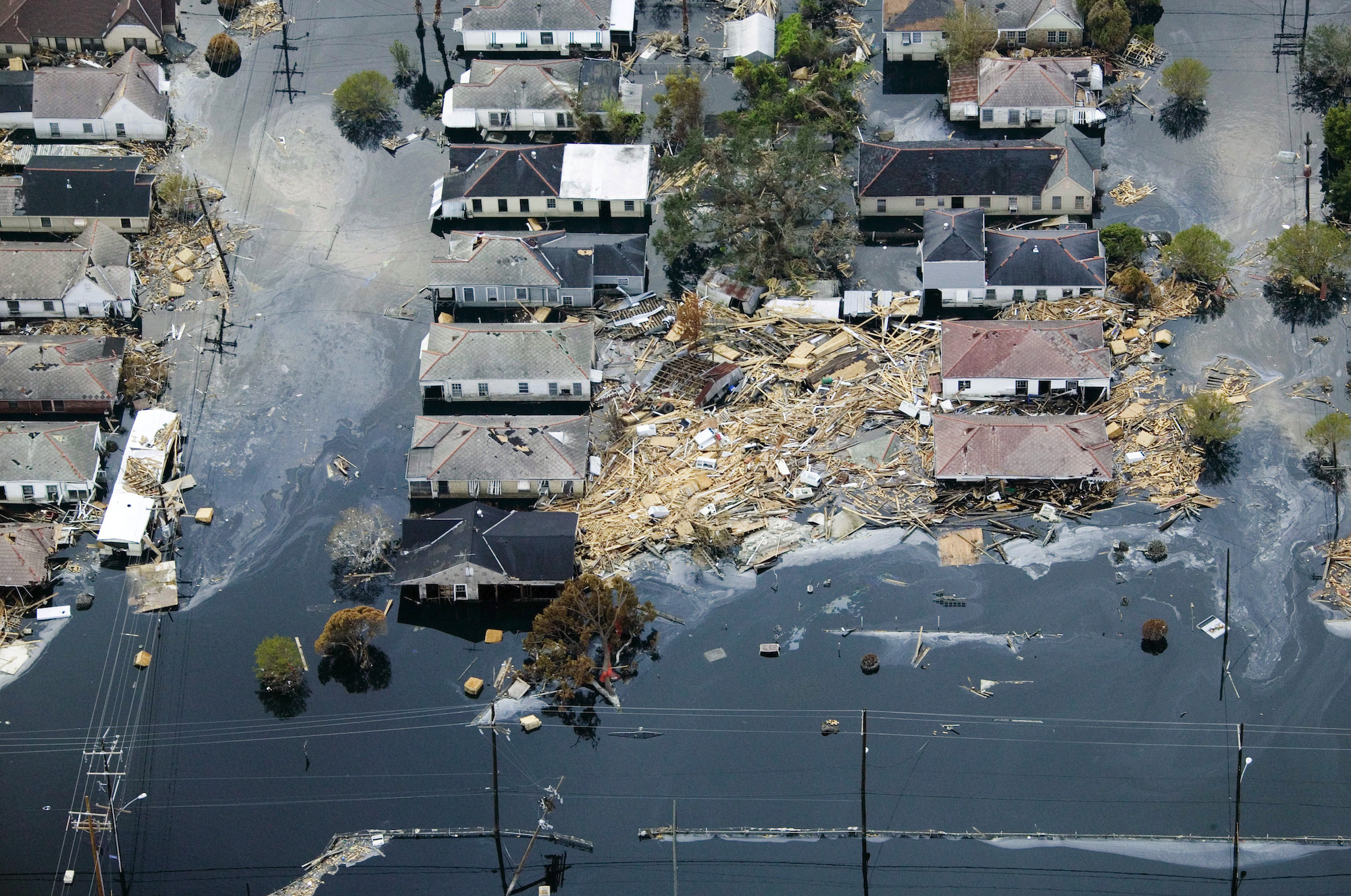
Hurricane Katrina made landfall three distinct times during its destructive passage across the United States. Its primary Gulf Coast landfall occurred on Monday, August 29, 2005, at 6:10 AM CDT near Buras-Triumph, Louisiana, followed by a final landfall at 9:45 AM CDT near the Louisiana-Mississippi border. An earlier, initial landfall struck Southeast Florida on Thursday, August 25, 2005, at 6:30 PM EDT.
Chronological Breakdown of Hurricane Katrina's Landfall Times
Understanding when Hurricane Katrina hit requires looking at its complete life cycle as recorded by the National Hurricane Center Tropical Cyclone Report for Hurricane Katrina. Because Katrina crossed several geographic zones over five days, its impact is categorized by three official landfalls, each marked by distinct meteorological characteristics, wind speeds, and regional consequences.
- Aug 25, 6:30 PM EDT: 1st Landfall: Hallandale Beach / Aventura, FL (Category 1 | 80 mph / 130 km/h)
- Aug 26 - Aug 28: Rapid Intensification over Gulf Loop Current (Reaches Peak Category 5 Status)
- Aug 29, 6:10 AM CDT: 2nd Landfall: Buras-Triumph, Plaquemines Parish, LA (Category 3 | 127 mph / 205 km/h)
- Aug 29, 9:45 AM CDT: 3rd Landfall: Mouth of Pearl River (LA/MS Border) (Category 3 | 120 mph / 190 km/h)
First Landfall: South Florida (August 25, 2005)
Hurricane Katrina first developed as Tropical Depression Twelve over the southeastern Bahamas on August 23, 2005. It upgraded to Tropical Storm Katrina on August 24 as it moved west-northwestward toward the Florida peninsula.
Katrina strengthened into a Category 1 hurricane on the Saffir-Simpson Hurricane Wind Scale just two hours before reaching the Florida coastline.
- Exact Time: Thursday, August 25, 2005, at 6:30 PM Eastern Daylight Time (EDT) / 22:30 Universal Coordinated Time (UTC).
- Landfall Location: Near Hallandale Beach and Aventura, on the border between Miami-Dade and Broward counties in Southeast Florida.
- Intensity at Impact: Maximum sustained winds of 80 mph (130 km/h) with a central barometric pressure of 984 millibars (mb).
- Duration over Land: Katrina spent approximately six hours traversing the Florida peninsula, dropping heavy rainfall across Miami-Dade, Broward, and Monroe counties before moving southwestward into the Gulf of Mexico early on August 26.
Second Landfall: Buras-Triumph, Louisiana (August 29, 2005)
After entering the warm waters of the Gulf of Mexico, Katrina underwent rapid intensification due to favorable upper-level winds and high sea-surface temperatures supported by the Gulf's Loop Current. By August 28, Katrina expanded dramatically into a Category 5 hurricane, reaching its peak intensity with sustained winds of 175 mph (280 km/h) and a minimum central pressure of 902 mb—one of the lowest pressures ever recorded in the Atlantic basin.
As the storm turned northward toward the Central Gulf Coast, it underwent an eyewall replacement cycle and encountered cooler shelf waters, causing its maximum sustained winds to decrease slightly before landfall. However, its physical wind field expanded significantly, driving a massive volume of water ahead of it.
- Exact Time: Monday, August 29, 2005, at 6:10 AM Central Daylight Time (CDT) / 11:10 UTC.
- Landfall Location: Near Buras-Triumph in Plaquemines Parish, Louisiana.
- Intensity at Impact: Category 3 hurricane with maximum sustained winds estimated near 127 mph (205 km/h) and a central pressure of 920 mb.
- Significance: This landfall delivered destructive winds and severe storm surge along the Mississippi River Delta, cutting off southern Plaquemines Parish and pushing immense storm surges into Saint Bernard Parish and Lake Borgne.
Third Landfall: Louisiana-Mississippi Border (August 29, 2005)
Following its short path across the marshlands of eastern Louisiana, Katrina crossed Breton Sound and made its final coastal landfall near the state boundary between Louisiana and Mississippi.
- Exact Time: Monday, August 29, 2005, at 9:45 AM Central Daylight Time (CDT) / 14:45 UTC.
- Landfall Location: Near the mouth of the Pearl River, adjacent to Pearlington, Mississippi, and Slidell, Louisiana.
- Intensity at Impact: Category 3 hurricane with maximum sustained winds of approximately 120 mph (190 km/h) and a central pressure of 928 mb.
- Significance: Because the highest storm surges in northern hemisphere tropical cyclones occur in the right-front quadrant of the eyewall, this third landfall produced catastrophic surge levels along the entire Mississippi coastline, destroying coastal infrastructure in Bay St. Louis, Pass Christian, Gulfport, and Biloxi.
Landfall Milestones and Meteorological Data
The following table summarizes the timing, coordinates, meteorological intensity, and location details for each of Hurricane Katrina's landfalls as verified by official NOAA National Centers for Environmental Information archive data.
| Landfall Event | Local Time & Date | UTC Time | Primary Location | Saffir-Simpson Category | Max Sustained Winds | Minimum Central Pressure |
|---|---|---|---|---|---|---|
| First Landfall | Aug 25, 2005 — 6:30 PM EDT | Aug 25 — 22:30 UTC | Hallandale Beach / Aventura, FL | Category 1 | 80 mph (130 km/h) | 984 mb |
| Peak Outer-Gulf Intensity | Aug 28, 2005 — 1:00 PM CDT | Aug 28 — 18:00 UTC | Central Gulf of Mexico | Category 5 | 175 mph (280 km/h) | 902 mb |
| Second Landfall | Aug 29, 2005 — 6:10 AM CDT | Aug 29 — 11:10 UTC | Buras-Triumph, Plaquemines Parish, LA | Category 3 | 127 mph (205 km/h) | 920 mb |
| Third Landfall | Aug 29, 2005 — 9:45 AM CDT | Aug 29 — 14:45 UTC | Mouth of Pearl River (LA/MS Border) | Category 3 | 120 mph (190 km/h) | 928 mb |
Timeline of New Orleans Levee Breaches and Inundation
The exact timing of Hurricane Katrina’s landfalls directly determined when municipal infrastructure, drainage networks, and flood protection systems in the Greater New Orleans area failed. Contrary to early popular belief, New Orleans did not sustain a direct hit from the storm's eye; rather, the city suffered catastrophic flooding due to storm surge driven into surrounding waterways during the morning hours of August 29.
- 05:00 AM CDT: Surge forces water into MRGO and Industrial Canal
- 06:00 AM CDT: Overtopping begins along Industrial Canal & E. Jefferson wall
- 06:30 AM CDT: First major structural breach at Industrial Canal (E. Bank)
- 06:30–7:30 AM: Initial failure along 17th Street Canal
- 07:30–8:30 AM: Multiple breaches open at London Avenue Canal
- 09:00 AM CDT: Widespread flooding active across 80% of Orleans Parish
Overnight Hours (12:00 AM – 5:00 AM CDT, August 29)
As Katrina approached from the south, strong easterly to southeasterly winds began pushing massive volumes of seawater from the Gulf of Mexico into Lake Borgne, Lake Pontchartrain, and the Mississippi River-Gulf Outlet (MRGO). Water levels in the navigational canals surrounding New Orleans began rising rapidly hours before the storm's core reached the coast.
Early Morning (5:00 AM – 7:30 AM CDT, August 29)
- 5:00 AM CDT: Surge water began entering the Industrial Canal, which connects Lake Pontchartrain to the Mississippi River.
- 6:00 AM CDT: Water levels overtopped floodwalls along the MRGO, inundating St. Bernard Parish and the Lower Ninth Ward.
- 6:30 AM CDT: The first catastrophic structural failure occurred along the eastern wall of the Industrial Canal, flooding the Lower Ninth Ward under several feet of water within minutes. Around this same period, structural instability developed along the 17th Street Canal wall near Lake Pontchartrain.
Peak Surge and Canal Failures (7:30 AM – 11:00 AM CDT, August 29)
- 7:30 AM – 8:30 AM CDT: As Katrina made its third landfall near the Pearl River, northwest winds behind the eye drove water from Lake Pontchartrain southward directly into city canals. The 17th Street Canal floodwall collapsed on its flood side, creating a 450-foot gap that poured lake water into the Lakeview neighborhood.
- 8:30 AM – 9:00 AM CDT: Two separate breaches formed along the London Avenue Canal floodwalls (near Pratt Drive and Mirabeau Avenue), flooding the Gentilly neighborhood.
- 11:00 AM CDT: Major breaches were open across all primary drainage canals. Floodwaters continued to flow freely into Orleans, St. Bernard, and Jefferson parishes until water levels between Lake Pontchartrain and the city reached hydrostatic equilibrium.
By August 30, approximately 80% of New Orleans was submerged, with water depths reaching up to 20 feet in low-lying residential areas.
Meteorological Dynamics: Why Timing and Scale Determined the Destruction
The timing of Hurricane Katrina's strength changes explains why its impact was so extreme relative to typical Saffir-Simpson wind classifications.
- Central Pressure (mb) [Lower number = Stronger total system energy]
- Peak (Aug 28): 902 mb
- Landfall (Aug 29): 920 mb
- Maximum Sustained Winds (mph) [Wind speed declined while surge potential remained extremely high]
- Peak (Aug 28): 175 mph
- Landfall (Aug 29): 127 mph
Rapid Intensification Over the Loop Current
Between August 26 and August 28, Katrina underwent a period of rapid intensification while passing over the Loop Current—a deep pool of warm ocean water in the central Gulf of Mexico. Within 36 hours, the storm’s pressure dropped from 945 mb to 902 mb. This deep barometric depression created an immense pressure gradient that accelerated surface winds and expanded the hurricane’s overall radius of maximum winds (RMW).
Kinetic Energy and Surge Generation
While Katrina weakened from a Category 5 to a Category 3 hurricane in the 18 hours prior to landfall due to an eyewall replacement cycle, its physical size meant its integrated kinetic energy (IKE) remained near record levels.
The large footprint of Category 3 to Category 5 winds pushed a deep ocean water mound forward for days. When the storm reached the shallow coastal waters of Louisiana and Mississippi, this accumulated kinetic energy transformed into a destructive storm surge that reached heights up to 28 feet (8.5 meters) in Pass Christian and Biloxi, Mississippi according to post-storm surveys published by the U.S. Geological Survey (USGS).
Atmospheric Barometric Pressure at Landfall
At the time of its second landfall in Plaquemines Parish (920 mb), Katrina was the third most intense hurricane on record to strike the United States mainland by central pressure, behind only the 1935 Labor Day Hurricane (892 mb) and Hurricane Camille in 1969 (900 mb). Because barometric pressure—rather than peak wind speed alone—governs storm surge generation, the 920 mb pressure forced coastal waters far beyond historical storm surge thresholds.
Regional Impact Timelines: South Florida to the Ohio Valley
The impacts of Hurricane Katrina shifted across geographical regions as the system tracked northeastward across North America from August 25 through August 31, 2005.
- Aug 25–26: Southeast Florida (Hallandale Beach / Miami / Keys)
- Aug 27–28: Central Gulf of Mexico (Intensification to Cat 5)
- Aug 29 AM: Louisiana Delta & Mississippi Coastline (Landfalls 2 & 3)
- Aug 29 PM: Central Mississippi & Alabama (Inland Wind Decay)
- Aug 30–31: Tennessee Valley, Ohio Valley & Northeast (Extratropical Transition)
Southeast Florida and the Florida Keys (August 25–26)
- August 25, 6:30 PM EDT: Landfall in Broward/Miami-Dade counties produced localized sustained winds of 80 mph and dumped over 10 to 14 inches of rain across South Florida.
- August 26, 2:00 AM EDT: The storm center exited the western Florida coast near Monroe County, entering the Gulf of Mexico south of Cape Sable.
- Impacts: Left over 1 million residents without electrical power, knocked down trees, and produced localized surface street flooding across the Miami metropolitan area.
Southeast Louisiana and Plaquemines Parish (August 29)
- August 29, 6:10 AM CDT: Eye of the storm made landfall in Buras-Triumph. Wind gusts exceeded 120 mph in coastal marshlands.
- Impacts: Destroyed structural foundations across Plaquemines and St. Bernard parishes, overturned commercial shipping vessels, and breached local protective levees.
Coastal Mississippi (August 29)
- August 29, 8:00 AM – 12:00 PM CDT: The eastern eyewall struck Hancock, Harrison, and Jackson counties.
- Impacts: A record storm surge reaching 24 to 28 feet pushed inland up to 6 miles across Biloxi, Gulfport, Ocean Springs, and Waveland, completely leveling coastal structures and highway bridges along U.S. Route 90.
Inland Mississippi, Alabama, and Tennessee Valley (August 29–30)
- August 29, 1:00 PM CDT: Katrina weakened to a tropical storm near Meridian, Mississippi.
- August 30, 5:00 AM CDT: The system downgraded to a tropical depression near Clarksville, Tennessee.
- Impacts: Sustained gale-force winds knocked out utility grids across inland Mississippi and western Alabama, while heavy rainfall caused riverine flooding across the Ohio Valley and Appalachian regions.
Frequently Asked Questions
What exact time did Hurricane Katrina hit New Orleans?
Hurricane Katrina made its second landfall in Plaquemines Parish, Louisiana—approximately 45 miles southeast of New Orleans—at 6:10 AM CDT on Monday, August 29, 2005. The storm's outer eyewall reached the metropolitan New Orleans area between 6:00 AM and 9:00 AM CDT, during which severe storm surge caused structural breaches in the city's levee network.
Was Hurricane Katrina a Category 5 when it hit Louisiana?
No. Hurricane Katrina reached Category 5 status while over the open waters of the central Gulf of Mexico on August 28, 2005. By the time it made landfall in Louisiana at 6:10 AM CDT on August 29, wind speeds had dropped to approximately 127 mph (205 km/h), making it a strong Category 3 hurricane. However, because of its broad size and extremely low central pressure (920 mb), it generated storm surge levels comparable to a Category 5 event.
What time did the levees break in New Orleans?
The first levee wall failures occurred during the early morning hours of August 29, 2005. The eastern bank of the Industrial Canal breached around 6:30 AM CDT, followed by structural failures along the 17th Street Canal between 6:30 AM and 7:30 AM CDT, and the London Avenue Canal between 7:30 AM and 8:30 AM CDT.
What time did Katrina make landfall in Florida?
Katrina made its first landfall on the southeastern coast of Florida at 6:30 PM EDT on Thursday, August 25, 2005, near Hallandale Beach and Aventura as a Category 1 hurricane with sustained winds of 80 mph.
Why did Katrina cause so much damage if its wind speed decreased at landfall?
Although peak sustained winds declined from 175 mph to 127 mph before landfall, Katrina’s massive physical footprint pushed a huge volume of water (integrated kinetic energy) toward the coast. The storm's exceptionally low minimum central pressure of 920 mb forced extreme storm surges into coastal bays and narrow drainage canals, which exceeded the design capacity of regional floodwalls and led to long-term flooding.
Summary of Historical Key Takeaways
To accurately document or reference the timeline of Hurricane Katrina, remember these verified historical facts:
- Three Distinct Landfalls: Katrina struck Florida on August 25 at 6:30 PM EDT (Cat 1), Louisiana on August 29 at 6:10 AM CDT (Cat 3), and the MS/LA border on August 29 at 9:45 AM CDT (Cat 3).
- Surge Before Eye: Levee failures in New Orleans began during the early morning hours of August 29 prior to the third landfall, driven by surge into canals rather than rain or a direct wind hit to the city center.
- Pressure Over Wind: The storm's extraordinary 920 mb surface pressure generated surge levels far higher than standard Category 3 wind speeds would suggest.
For historical researchers, emergency management personnel, and meteorologists, referring to official UTC and local time designations ensures precise correlation between atmospheric radar data and structural failure reports.