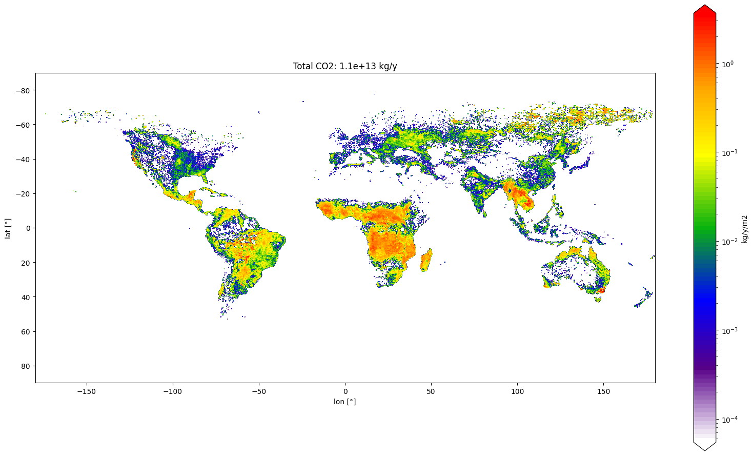
The 2021 global wildfire season released an estimated 1.76 gigatons of carbon emissions into the atmosphere, driven by catastrophic burning events in North America, Siberia, and the Mediterranean. These emissions significantly surpassed historical averages, intensifying global climate feedback loops and severely degrading regional air quality across multiple continents.
Introduction to 2021 Global Wildfire Dynamics
Understanding the scale of the 2021 global wildfire season requires examining the complex interplay between meteorological anomalies, prolonged regional droughts, and accumulated forest fuels. Throughout that year, scientific agencies monitoring atmospheric composition—such as the Copernicus Atmosphere Monitoring Service (CAMS)—tracked unprecedented carbon outputs. These outputs were not merely a localized forestry concern; they represented a major perturbation in the global carbon cycle, highlighting how warming temperatures and shifting precipitation patterns amplify terrestrial carbon loss.
The year 2021 proved exceptional due to the sheer intensity and persistence of fires in high-latitude regions, particularly in northeastern Siberia, alongside devastating forest fires spanning western North America and parts of Southern Europe, Turkey, and North Africa. This overview analyzes the primary regional drivers, the composition of the released emissions, the monitoring methodologies utilized by global scientific bodies, and the long-term implications for climate science and emergency management.
Methodologies for Tracking Wildfire Emissions
Quantifying global wildfire emissions relies on a sophisticated combination of satellite observation, atmospheric inversion modeling, and ground-based validation. Agencies like CAMS utilize the Global Fire Assimilation System (GFAS), which assimilates radiative power observations captured by satellite-borne sensors.
Satellite Observations and Radiative Power
Satellite instruments, such as the Moderate Resolution Imaging Spectroradiometer (MODIS) aboard NASA’s Terra and Aqua satellites and the Visible Infrared Imaging Radiometer Suite (VIIRS), measure Fire Radiative Power (FRP). FRP quantifies the rate of radiant heat energy released by active fires.
- Detection: Sensors detect thermal anomalies (hotspots) on the Earth's surface in near-real-time.
- Quantification: The total radiant energy emitted over the duration of the burn is calculated using FRP measurements.
- Conversion: Empirical conversion factors translate the thermal energy estimates into daily dry matter combustion rates, which subsequently yield specific trace gas and aerosol emission estimates.
Atmospheric Inversion Modeling and Chemical Transport
While satellite remote sensing provides rapid spatial and temporal mapping, atmospheric transport models help verify these estimates by measuring actual pollutant concentrations in the atmosphere. Chemical transport models simulate how winds, atmospheric mixing, and chemical reactions distribute smoke plumes.
By comparing simulated concentrations with satellite retrievals of carbon monoxide (CO), carbon dioxide ($\text{CO}_2$), and aerosol optical depth (AOD), scientists can constrain emission inventories and adjust for cloud cover or heavy smoke obscured from direct satellite view.
Major Regional Breakdown of 2021 Emissions
The global total of 1.76 gigatons of carbon emitted in 2021 was heavily concentrated in specific geographic zones experiencing extreme weather conditions.
| Region | Primary Contributing Areas | Estimated Impact & Characteristics |
|---|---|---|
| Siberia (Russia) | Sakha Republic, Irkutsk, and Krasnoyarsk | Record-breaking boreal forest fires; massive peatland combustion releasing deep soil carbon. |
| North America | Western United States (California, Oregon) and British Columbia (Canada) | Extreme megafires driven by multi-year megadroughts; prolonged air quality degradation. |
| Mediterranean | Turkey, Greece, Italy, and Algeria | Intense summer heatwaves coupled with severe drought; heavy urban-wildland interface impacts. |
| South America | Brazilian Amazon, Pantanal, and central Argentina | Continued agricultural clearing fires compounded by drought conditions. |
Siberia and the Boreal Forest Crisis
Siberia experienced one of its most destructive fire seasons on record in 2021. The Sakha Republic (Yakutia) was particularly hard hit, with fires burning across millions of hectares of boreal taiga.
Boreal forests and underlying peat soils store immense quantities of carbon. When these areas burn, they release not only contemporary carbon captured by trees but also ancient organic matter stored in permafrost and peat layers over millennia. The 2021 Siberian fires contributed a substantial fraction of the global total, with smoke plumes traveling thousands of kilometers, occasionally reaching the North Pole.
North American Megafires
In North America, the 2021 season followed severe, persistent droughts across the western United States and western Canada. The Dixie Fire in California became the largest single wildfire in the state's modern history, burning nearly a million acres.
The primary driver of these emissions was the extreme dryness of vegetation, characterized by low fuel moisture content in timber and chaparral. The resulting pyrocumulonimbus clouds injected smoke into the stratosphere, allowing smoke particles to travel globally and impacting solar radiation balances.
Mediterranean and Southern European Crises
During the summer of 2021, a historic heatwave gripped Southern Europe and the wider Mediterranean basin. Turkey recorded its most severe wildfire season in history, with widespread crown fires sweeping through coastal pine forests. Greece, Italy, and Spain also suffered extensive losses.
Unlike the remote boreal forests of Siberia, Mediterranean fires frequently threaten populated areas, agricultural lands, and tourism infrastructure, leading to severe socio-economic disruption alongside high greenhouse gas emissions.
Chemical Composition and Atmospheric Impacts
Wildfire emissions are complex mixtures of gases and particulate matter that directly influence atmospheric chemistry, air quality, and radiative forcing.
- 2021 Global Wildfire Emissions
- Greenhouse Gases
- Carbon Dioxide (CO2)
- Carbon Monoxide (CO)
- Methane (CH4)
- Particulate Matter
- Fine Particulate Matter (PM2.5)
- Black Carbon / Soot
- Organic Carbon Aerosols
- Greenhouse Gases
Greenhouse Gases ($\text{CO}_2$, $\text{CO}$, and $\text{CH}_4$)
The dominant carbonaceous emission by mass is carbon dioxide. While $\text{CO}_2$ emissions from wildfires are theoretically part of the natural carbon cycle—assuming vegetation regrows and re-absorbs the carbon over time—the unprecedented scale and intensity of 2021 fires raised concerns among climate scientists. When mature forests are replaced by scrubland or degraded by repeated burns, the carbon sink capacity is permanently diminished.
Additionally, incomplete combustion processes generate significant quantities of carbon monoxide and methane, powerful short-lived climate pollutants that affect tropospheric chemistry and hydroxyl radical abundance.
Particulate Matter ($\text{PM}_{2.5}$) and Black Carbon
Fine particulate matter with a diameter of 2.5 micrometers or less ($\text{PM}_{2.5}$) poses severe public health risks. Inhaling wildfire smoke leads to cardiovascular and respiratory distress, hospitalizations, and premature mortality.
Black carbon, a component of particulate matter produced by incomplete combustion, absorbs solar radiation directly in the atmosphere. When black carbon settles on snow and ice surfaces in high-latitude or alpine regions, it decreases surface albedo, accelerating snowmelt and further exacerbating warming trends in fragile ecosystems like the Arctic.
Comparison With Historical Baselines
Evaluating 2021 data requires contextualizing it against multi-decadal baselines provided by monitoring infrastructures.
- Anomaly Trends: While total global carbon emissions from fires can fluctuate annually—often driven by tropical savanna fires in Africa—the 2021 season was anomalous due to the extreme concentration of emissions in northern high latitudes.
- Intensification Rate: Data from the Copernicus Atmosphere Monitoring Service indicated that Siberian fire emissions in July and August 2021 significantly exceeded those recorded in any previous year of the CAMS satellite record (which began in 2003).
- Permanence of Carbon Loss: Historical analyses suggest that northern latitude ecosystems are shifting from net carbon sinks to net carbon sources as fire frequency increases under a warming climate.
Mitigation, Monitoring, and Future Outlook
Mitigating the impacts of extreme wildfire seasons requires integrated strategies spanning forest management, international cooperation, and advanced early-warning systems.
Enhancing Early Detection and Response
Governments and international bodies continue to invest in high-resolution satellite constellations and artificial intelligence-driven predictive models. These tools enable fire management agencies to detect ignition points faster, optimize resource allocation, and issue targeted public health advisories regarding air quality degradation.
Fuel Management and Prescribed Burning
In fire-adapted ecosystems, decades of fire suppression have led to unnatural fuel accumulations. Implementing controlled, prescribed burns during safe weather windows helps reduce fuel loads, mitigating the risk of high-intensity crown fires that produce the highest volume of catastrophic emissions.
Policy and Climate Commitments
International frameworks increasingly recognize the need to account for natural disturbances in national greenhouse gas inventories. Enhancing ecosystem resilience through reforestation, peatland re-wetting, and stricter land-use regulations remains essential to curbing future emission spikes.
Frequently Asked Questions
How many total carbon emissions did global wildfires produce in 2021?
Global wildfires released an estimated 1.76 gigatons of carbon into the atmosphere in 2021, driven largely by exceptional burning seasons in Siberia, North America, and the Mediterranean region.
Why were the 2021 Siberian wildfires significant for global emissions?
The 2021 Siberian fires burned across vast boreal forests and carbon-rich peat soils. This resulted in the release of ancient, stored carbon that cannot be easily re-absorbed by short-term vegetation regrowth, accelerating climate feedback loops.
What is the primary tool used to monitor global wildfire emissions?
Scientific bodies primarily use satellite observations—such as Fire Radiative Power (FRP) data from MODIS and VIIRS sensors—combined with atmospheric transport and chemical inversion models to calculate daily emission estimates.
How do wildfire emissions impact human health?
Wildfires release massive quantities of fine particulate matter ($\text{PM}_{2.5}$), carbon monoxide, and toxic organic compounds. Inhalation of these pollutants causes acute and chronic respiratory and cardiovascular illnesses, impacting populations thousands of miles away from the burn sites.
Are wildfire carbon emissions counted in national greenhouse gas inventories?
While most carbon dioxide released by natural fires is considered part of the biogenic carbon cycle, human-induced changes in fire regimes and emissions from degraded peatlands and permanent forest loss are increasingly factored into global carbon budgets and climate mitigation planning.
Next Actions for Researchers and Policy Makers
To address the growing threat of extreme wildfire emissions, stakeholders should focus on standardizing cross-border atmospheric monitoring protocols, increasing funding for preventative forest management, and integrating high-resolution satellite datasets into national climate adaptation frameworks. Prioritizing the restoration of degraded peatlands and implementing rigorous local air-quality warning systems remain critical steps for minimizing environmental and public health impacts.