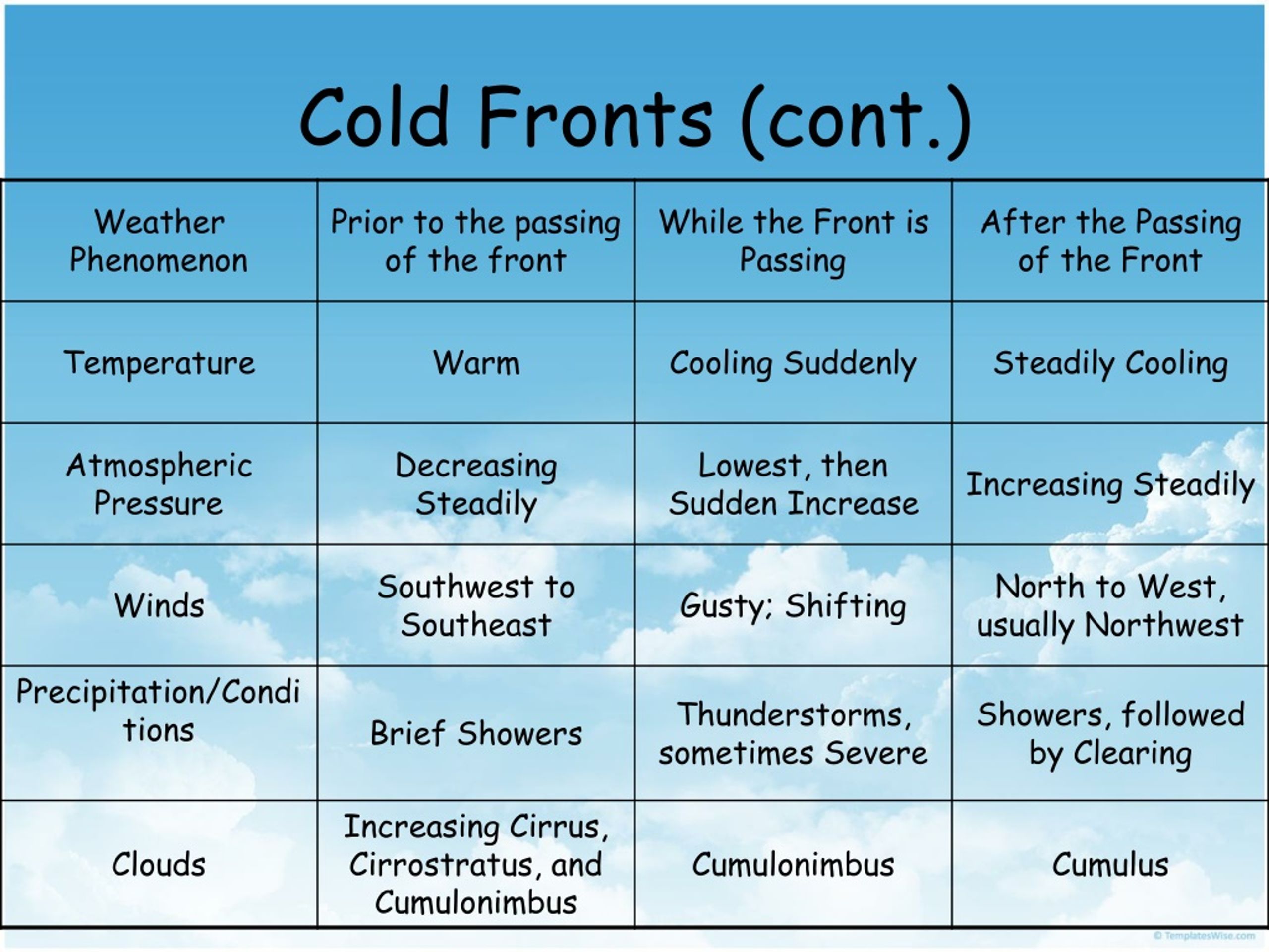
A cold front is a transition zone where a colder air mass replaces a warmer air mass, and it is fundamentally characterized as a low-pressure feature because it resides within a trough of low atmospheric pressure. As the front approaches, barometric pressure drops to its lowest point, subsequently rising sharply once the denser, cold air settles behind the boundary.
The Relationship Between Atmospheric Pressure and Cold Fronts
To understand why a cold front is categorized as a low-pressure feature, one must first look at the structure of the atmosphere on a synoptic scale. In meteorology, weather patterns are often dictated by the movement of "cells" or "masses" of air. A cold front does not exist in isolation; it is almost always a structural component of an extratropical cyclone, which is a large-scale low-pressure system.
Atmospheric pressure is essentially the weight of the air above a specific point. In a low-pressure system, air is generally rising. As air rises, it exerts less downward force on the surface, leading to a lower barometric reading. Cold fronts are positioned along the "trough" of these systems. A trough is an elongated area of relatively low pressure extending from the center of a cyclone. Think of the low-pressure center as the hub of a wheel and the cold front as one of the spokes. Because the air converges at this boundary, the front itself represents a localized minimum in pressure compared to the air masses on either side of it.
By 2026, satellite and surface sensor density has reached a point where we can observe these pressure fluctuations with incredible precision. When a cold front moves toward a station, the barograph (an instrument that records pressure over time) typically shows a steady decline. This is because the station is moving deeper into the low-pressure trough associated with the front. The moment the front passes, the pressure hits its lowest value and then begins to climb rapidly. This rise occurs because the cold air following the front is much denser and "heavier" than the warm air it replaced.
The Physics of Frontal Lifting and Convergence
The status of a cold front as a low-pressure feature is also driven by the mechanical action of air convergence. Along the boundary of a cold front, two different air masses meet. The cold air mass is inherently denser than the warm air mass it is displacing. Because it is denser, it acts like a physical wedge, forcing the lighter, warmer air to rise abruptly.
This lifting mechanism is a hallmark of low-pressure environments. In meteorology, convergence refers to air flowing together. When air converges at the surface along the frontal boundary, it has nowhere to go but up. This vertical motion is what creates the clouds and precipitation typically associated with cold fronts. This "upward evacuation" of air at the surface is precisely what maintains the lower pressure along the frontal line.
Furthermore, the "kink" in the isobars (lines of constant pressure) on a weather map illustrates this relationship. When you look at a surface analysis map, isobars will often bend sharply as they cross a cold front, forming a "V" shape that points away from the low-pressure center. This geometric pattern is the visual representation of the pressure trough. Without the low-pressure environment, the convergence and subsequent lifting of air that defines a cold front would not occur with the same intensity.
Distinguishing Between the Front and the Cyclone
While a cold front is a low-pressure feature, it is important to distinguish it from the low-pressure center itself. A mid-latitude cyclone typically consists of a center of lowest pressure with two or more fronts extending from it: the warm front and the cold front.
- The Cyclone Center: This is the point of absolute minimum pressure. In the Northern Hemisphere, winds circulate counter-clockwise around this center.
- The Cold Front: This extends out from the center, usually toward the south or southwest. It marks the boundary where the cold air, rotating around the backside of the low, catches up to and displaces the warm air in the "warm sector."
- The Warm Sector: This is the region of air between the cold front and the warm front. It is usually characterized by higher humidity and warmer temperatures, but it is also under the influence of the overall low-pressure system.
In 2026, meteorological models emphasize the "conveyor belt" theory of cyclones. The cold front is seen as the leading edge of the "cold conveyor belt," a stream of air that originates in the upper atmosphere or higher latitudes and sinks toward the surface, maintaining high density and driving the low-pressure trough forward.
Weather Changes Associated with Cold Front Passage
The passage of a cold front is one of the most dramatic events in daily weather. Because it is a low-pressure feature, it brings together all the ingredients for active weather: moisture, instability, and a lifting mechanism. The severity of the weather depends on the contrast between the two air masses and the speed of the front.
Before the Front Passes
As the low-pressure feature approaches, the "warm sector" dominates. Winds are typically from the south or southwest (in the Northern Hemisphere). Because the pressure is falling as the trough nears, the air can hold more moisture, and humidity levels often rise. You may see cirrus clouds thickening into stratocumulus.
During the Frontal Passage
As the pressure reaches its minimum, the weather reaches its peak intensity. The abrupt lifting of warm, moist air leads to the formation of cumulonimbus clouds. This often results in short-lived but intense bursts of rain, thunderstorms, and occasionally severe weather like hail or tornadoes. The wind "veers," meaning it shifts rapidly in a clockwise direction—often from the southwest to the northwest.
After the Front Passes
Once the trough line passes, the pressure begins to rise. This is the "high-pressure" side of the feature (though still technically part of the larger cyclonic system). The air turns colder, and the dew point drops significantly, leading to a much "crisper" or drier feel to the atmosphere. The sky usually clears quickly as the sinking cold air suppresses cloud formation.
Comparing Frontal Characteristics
The following table summarizes the transition of various meteorological elements as this low-pressure feature passes a specific location.
| Feature | Before Front Passage | During Front Passage | After Front Passage |
|---|---|---|---|
| Atmospheric Pressure | Decreasing steadily | Reaches minimum (trough) | Increasing rapidly |
| Temperature | Warm and stable | Sudden, sharp drop | Cold and stabilizing |
| Wind Direction | South to Southwest | Gusty and shifting | West to Northwest |
| Dew Point | High/Humid | Sharp decrease | Low/Dry |
| Clouds | Cirrus, then Stratocumulus | Cumulonimbus (Towering) | Clearing (Cumulus) |
| Precipitation | Light patches or none | Heavy rain/Thunderstorms | Ending quickly |
The Norwegian Cyclone Model and Frontal Evolution
To fully grasp why fronts are low-pressure features, we look back at the Norwegian Cyclone Model, developed in the early 20th century, which remains the foundation of synoptic meteorology in 2026. This model describes the lifecycle of a low-pressure system (cyclogenesis).
It begins with a stationary front—a boundary between cold and warm air with no movement. A disturbance, often caused by the jet stream aloft, creates a "wave" in this boundary. As the wave develops, a low-pressure center forms at the apex. The circulation around this low-pressure center pulls cold air south, creating the cold front, and warm air north, creating the warm front.
As the system matures, the cold front, which moves faster because cold air is more efficient at displacing warm air, eventually catches up to the warm front. This process is called occlusion. When the fronts merge, they form an occluded front, and the "warm sector" is lifted entirely off the ground. At this point, the low-pressure system has reached its peak intensity and begins to dissipate (frontolysis). This cycle proves that the cold front is not just a side effect but a primary driver of the low-pressure system's energy exchange.
Why Cold Fronts Matter for Aviation and Industry
Understanding that a cold front is a low-pressure feature is critical for various sectors, particularly aviation. Pilots must be aware of the "altimeter setting" when crossing a front. Because the pressure drops at the front, an altimeter that is not adjusted for the local pressure change will give an incorrect altitude reading, which is a significant safety risk.
Furthermore, the wind shear—a sudden change in wind speed or direction—associated with the low-pressure trough can be dangerous during takeoff and landing. In 2026, advanced Low-Level Wind Shear Alert Systems (LLWAS) are used at major airports to detect these frontal boundaries in real-time, helping pilots navigate the turbulence and pressure shifts inherent in these features.
In the energy sector, cold fronts are tracked to predict surges in heating demand. Because the pressure rise following a front brings in dense, cold polar air, utility companies can use barometric trends to forecast exactly when a "cold snap" will hit a metropolitan area, allowing them to manage the load on the electrical grid more effectively.
Frequently Asked Questions
Does a cold front always mean it will rain?
Not necessarily. While a cold front is a low-pressure feature that encourages air to rise, rain only occurs if there is sufficient moisture in the atmosphere. If the air mass being displaced is very dry, the front might pass with nothing more than a shift in wind, a drop in temperature, and some scattered clouds. This is often referred to as a "dry cold front."
Why does the pressure rise so quickly after the front passes?
The pressure rises because the air behind the cold front is significantly denser. Cold air molecules are packed more tightly together than warm air molecules. When this dense air mass moves over a location, it weighs more, which the barometer records as an increase in atmospheric pressure. This is often the most reliable sign that the frontal boundary has successfully passed.
Is a "trough" the same thing as a cold front?
They are related but not identical. A trough is a general term for any elongated area of low pressure. A cold front is a specific type of trough that marks the boundary between two different air masses (cold and warm). All cold fronts are located in troughs, but not all troughs are cold fronts. Some troughs are simply "pressure ripples" without a significant temperature change behind them.
Can a cold front move from south to north?
In the Northern Hemisphere, it is extremely rare. Cold fronts are driven by the circulation of low-pressure systems and the general movement of the jet stream, which typically pushes polar air from the northwest toward the southeast. However, in the Southern Hemisphere, the directions are reversed, and cold fronts move from the south (the Antarctic) toward the north.
How do meteorologists identify a cold front on a map in 2026?
Meteorologists look for a combination of four factors: a sharp temperature gradient, a significant shift in wind direction (veering), a "kink" in the isobars indicating a pressure trough, and a moisture boundary (the dew point jump). By 2026, automated weather stations and AI-enhanced satellite imagery allow these boundaries to be mapped with sub-kilometer accuracy.
Final Recommendation for Weather Monitoring
If you are tracking a cold front for personal safety or professional planning, do not rely solely on temperature. Monitor the barometric pressure. By watching for the pressure to bottom out and then begin a sharp rise, you can determine the exact moment the frontal boundary has passed your location. This is often the most accurate way to predict when the most severe weather will end and when clearing conditions will begin. For the most up-to-date information, always consult official sources such as the National Oceanic and Atmospheric Administration (NOAA) or the National Weather Service (NWS).