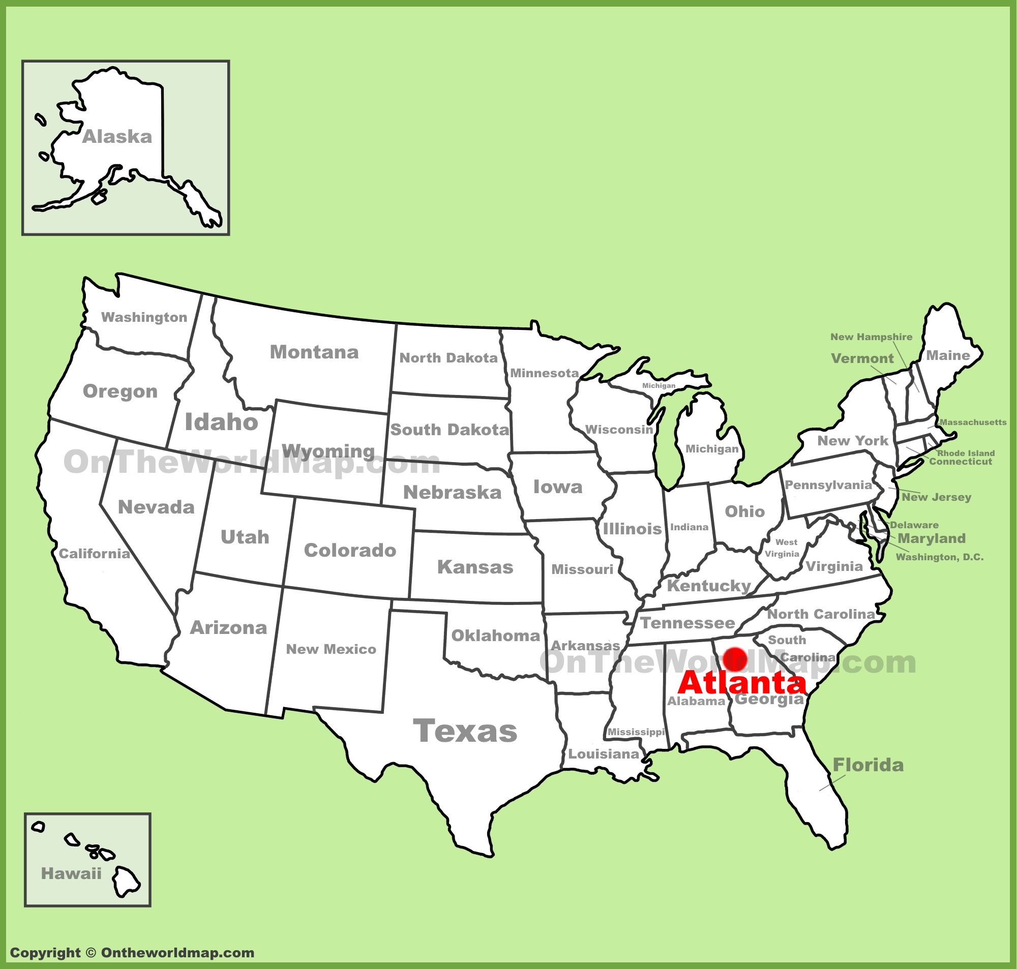
Atlanta is located in the North-Central region of Georgia, specifically at coordinates 33.7490° N, 84.3880° W. As the seat of Fulton County and the capital of the state, it sits on the Piedmont Plateau in the foothills of the Appalachian Mountains, serving as the primary commercial and transportation hub for the Southeastern United States.
Understanding Atlanta's position on the map requires more than just identifying a point on a grid. In 2026, Atlanta remains one of the most strategically significant cities in North America, acting as the "Gateway to the South." Its location is defined by a unique combination of high elevation, complex hydrology, and a central placement within the Sun Belt that has dictated its growth from a 19th-century railroad terminus to a 21st-century global powerhouse.
Precise Geographic Coordinates and Cartographic Placement
When looking at a map of the United States, Atlanta is positioned in the southeastern quadrant, approximately 250 miles inland from the Atlantic Ocean and about the same distance north of the Gulf of Mexico. This inland position protects the city from the direct impact of coastal storm surges while keeping it within a humid subtropical climate zone.
Latitude and Longitude Details
The primary center point of Atlanta, often measured from the Georgia State Capitol or "Milepost 0," sits at 33° 44' 56" North latitude and 84° 23' 24" West longitude.
- The 33rd Parallel: Atlanta’s latitudinal position puts it on the same approximate line as Casablanca, Morocco, and Baghdad, Iraq. This positioning is a major factor in its long, hot summers and relatively mild winters.
- The 84th Meridian: Longitudinally, Atlanta is almost directly north of Panama City, Florida, and south of Cincinnati, Ohio. This central positioning within the Eastern Time Zone makes it a critical node for East Coast commerce.
Elevation and Topography
One of the most distinctive features of Atlanta’s position on the map is its elevation. Sitting at an average of 1,050 feet (320 meters) above sea level, Atlanta has one of the highest elevations of any major city east of the Mississippi River. The city is situated on the Piedmont Plateau, a region characterized by rolling hills and ancient, weathered rock formations that precede the higher peaks of the Blue Ridge Mountains to the north.
This elevation is not merely a statistical curiosity; it defines the city’s drainage, temperature, and even its historical development. The high ground provided a natural advantage for the railroad surveyors who first mapped the area in the 1830s, as it allowed for easier construction of tracks along the ridges rather than through the swampy lowlands found further south in the Atlantic Coastal Plain.
The Eastern Continental Divide: A Unique Geographic Marker
Perhaps the most significant geographical "hidden feature" of Atlanta's position is the Eastern Continental Divide. This hydrological boundary runs directly through the city, roughly following the path of DeKalb Avenue and the MARTA rail line.
Hydrological Significance
The divide separates water drainage between the Atlantic Ocean and the Gulf of Mexico.
- Atlantic Side: Rain falling on the eastern side of the divide flows into the Altamaha River system and eventually enters the Atlantic Ocean.
- Gulf Side: Rain falling on the western side flows into the Chattahoochee River, eventually joining the Apalachicola River and emptying into the Gulf of Mexico.
Because Atlanta sits atop this ridge, it does not have a large navigable river running through its downtown core. The Chattahoochee River, which forms the city's northwestern boundary, is the primary source of drinking water but is not deep enough for the heavy commercial shipping that built cities like New Orleans or Memphis. This forced Atlanta to rely on its map position as a rail and road hub rather than a maritime port.
Regional Connectivity and the "Southeast Hub"
In 2026, Atlanta’s position on the map is synonymous with connectivity. It serves as the "anchor" for the Piedmont Atlantic Megaregion, an urban corridor stretching from Birmingham, Alabama, to Charlotte, North Carolina.
Proximity to Major Southeastern Cities
Atlanta’s central location makes it an ideal regional headquarters. The following table illustrates its proximity to other major metropolitan areas, reinforcing its status as a central logistical node.
| Destination | Direction | Approximate Distance (Miles) | Primary Route |
|---|---|---|---|
| Birmingham, AL | West | 150 | I-20 |
| Charlotte, NC | Northeast | 245 | I-85 |
| Nashville, TN | Northwest | 250 | I-75 |
| Jacksonville, FL | Southeast | 345 | I-75 |
| Savannah, GA | Southeast | 250 | I-16 |
| Montgomery, AL | Southwest | 160 | I-85 |
The Interstate "Crossroads"
The city is the meeting point of three major Interstate highways, which are clearly visible on any regional map:
- I-75: Connects the Great Lakes region to Florida.
- I-85: Connects the Northeast/Mid-Atlantic to the Deep South.
- I-20: Connects the Atlantic coast (South Carolina) to the American Southwest (Texas).
The "Downtown Connector," where I-75 and I-85 merge through the heart of the city, is one of the most heavily trafficked stretches of road in the United States. While this often leads to significant congestion, it reinforces Atlanta's inescapable presence on any map of American logistics.
Atlanta’s Position in the Global Aviation Network
You cannot discuss Atlanta's position on a map without referencing Hartsfield-Jackson Atlanta International Airport (ATL). Located just south of the city limits (straddling the border of Fulton and Clayton counties), its map coordinates are 33.6407° N, 84.4277° W.
The "Two-Hour" Rule
From its specific position in the Southeast, Atlanta is within a two-hour flight of 80% of the United States population. This geographical advantage is why Delta Air Lines maintains its primary global hub here. In the context of 2026 global commerce, Atlanta's position makes it a more efficient transfer point for international flights coming from South America and Europe than many coastal cities.
The airport itself is so large that it functions as its own geographic entity on the map, featuring its own internal transit systems and serving as the primary economic engine for the state of Georgia. Its placement was chosen specifically because the flat, high-plateau land south of the city allowed for the massive runway expansion required for the jet age.
The "City in a Forest" Canopy
From a satellite or cartographic perspective, Atlanta is frequently identified as the "City in a Forest." Unlike the dense, concrete-heavy grids of New York or Chicago, Atlanta’s map is dominated by green.
In 2026, the city continues to maintain one of the highest percentages of tree canopy coverage of any major U.S. city, estimated at approximately 46-48%. This greenery is visible on topographical maps and helps mitigate the "urban heat island" effect that plagues other Southern cities. The canopy consists primarily of loblolly pines, white oaks, and maples, which thrive in the red clay soil characteristic of the Piedmont region.
Historical Mapping: From Terminus to Metropolis
Atlanta's position was not chosen for its beauty or access to water, but for its mathematical efficiency. In 1837, the Western and Atlantic Railroad decided to end its line at a specific spot that would allow for a future connection to Savannah.
- Terminus: The original name of the settlement, reflecting its position as the "end of the line."
- Marthasville: A brief secondary name before the city became Atlanta (a feminine derivative of "Atlantic").
- The Zero Mile Post: Still located in the Underground Atlanta area, this marks the precise center of the railroad's mapping and the catalyst for the city's growth.
The map of Atlanta today still reflects this history. The streets do not follow a traditional cardinal grid (North-South-East-West) because the original roads were built parallel to the railroad tracks, which followed the winding ridges of the Piedmont hills. This creates the famously confusing "spoke and wheel" layout that defines the city's modern street map.
Environmental and Climate Considerations of its Position
Being located at 33° N latitude and 1,000+ feet of elevation creates a unique climate profile. While Atlanta is firmly in the "Deep South," its position in the foothills provides a slight reprieve from the extreme humidity and heat found in low-lying coastal Georgia or Florida.
The Appalachian Influence
The mountains to the north act as a buffer. During winter months, "cold air damming" can occur when cold air from the northeast gets trapped against the eastern side of the Appalachian Mountains and spills over into Atlanta. This occasionally results in the ice storms for which the city is infamous. On a map, you can see how the city sits right at the "squeeze point" where the mountains end and the plains begin, making it a battleground for different air masses.
Verifying Atlanta's Position in 2026
If you are using digital mapping tools or GPS in 2026, it is important to distinguish between the City of Atlanta and the Atlanta Metropolitan Statistical Area (MSA).
- The Core City: Occupies approximately 136 square miles. Its map is bounded roughly by the I-285 "Perimeter" highway, though the city limits are actually much smaller than the area inside the loop.
- The Metropolitan Area: Sprawls across 28+ counties and over 8,000 square miles. When people refer to "Atlanta's position" in a commercial sense, they are often referring to this massive footprint that extends into the North Georgia mountains and the South Georgia plains.
Geographic Comparison Table: Atlanta vs. Other Hubs
| City | Latitude | Longitude | Elevation (ft) | Biome |
|---|---|---|---|---|
| Atlanta, GA | 33.74° N | 84.38° W | 1,050 | Piedmont Forest |
| Charlotte, NC | 35.22° N | 80.84° W | 760 | Piedmont Plateau |
| Birmingham, AL | 33.51° N | 86.81° W | 600 | Ridge and Valley |
| Nashville, TN | 36.16° N | 86.78° W | 597 | Central Basin |
| Dallas, TX | 32.77° N | 96.79° W | 430 | Blackland Prairie |
FAQs About Atlanta's Position on the Map
Is Atlanta considered a mountain city?
While not located in the mountains, Atlanta is located in the Appalachian foothills. You can see the start of the Blue Ridge Mountains on the horizon from many of the city's skyscrapers. Peaks like Kennesaw Mountain and Stone Mountain (a massive granite monadnock) are significant geographic landmarks within the immediate metropolitan area.
How far is Atlanta from the coast?
Atlanta is approximately 250 miles (400 km) from the Atlantic coast at Savannah, Georgia, and roughly the same distance from the Gulf of Mexico at the Florida Panhandle. This inland position is a primary reason why it was chosen as a strategic military and rail site during the 19th century, as it was more difficult for naval forces to reach.
Why does Atlanta have so many "Peachtree" streets?
The "Peachtree" name is ubiquitous on the Atlanta map, with over 70 variations. This is tied to the city’s geography; the original "Peachtree Trail" followed the high ridge of the Eastern Continental Divide. Because this ridge was the easiest path for travel, many subsequent roads and developments were named after it, leading to the cartographic confusion travelers experience today.
Does the Eastern Continental Divide affect my GPS or map?
It does not affect GPS signal, but it significantly affects the topographical map and local infrastructure. You will notice that many of the oldest streets and rail lines stay on the "high ground" of the divide to avoid the steep valleys and creek beds that characterize the rest of the city's terrain.
What is the significance of the I-285 "Perimeter"?
On a map, I-285 is a 64-mile loop that encircles the city. It serves as a major geographical divider in local culture; residents are often described as living "ITP" (Inside the Perimeter) or "OTP" (Outside the Perimeter). This loop is the primary reference point for understanding the scale of the city's map.
Strategic Recommendation for Map Users
When navigating or studying Atlanta’s position in 2026, always prioritize topographical or "terrain" layers on your map. Because the city is built on a series of ridges and valleys rather than a flat plain, distance "as the crow flies" is rarely an accurate measure of travel time. Understanding the relationship between the major Interstates (I-75, I-85, I-20) and the I-285 loop is the most effective way to conceptualize the city’s layout and its position relative to the rest of the Southeastern United States.