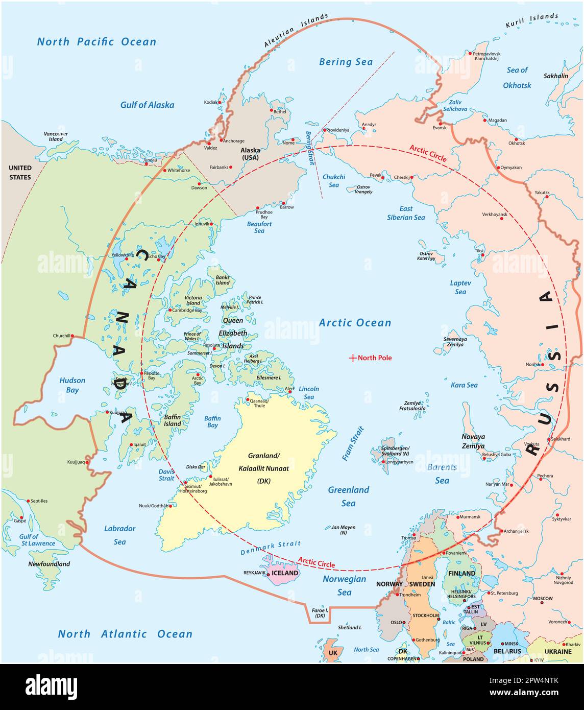
Alaska lies partly inside the Arctic Circle, a significant geographical reality that defines much of the state’s climate, day-night cycles, and ecological character. Roughly one-third of Alaska’s total landmass—approximately 200,000 square miles—extends north of the 66°33' N parallel, encompassing the Brooks Range, the North Slope, and the state’s extensive Arctic coastline.
Defining the Arctic Circle and Alaska’s Northern Boundary
The Arctic Circle is a circle of latitude approximately 66°33′ north of the Equator. It marks the southernmost latitude where the sun can remain continuously above the horizon for 24 hours at the summer solstice and below the horizon for 24 hours at the winter solstice. For Alaska, this line is not merely an abstract coordinate but a functional boundary that dictates the seasonal rhythms of the northernmost communities.
When examining a map of the United States, it is common to overlook the sheer scale of Alaska’s northern territory. The Arctic Circle passes through the northern portion of the state, effectively dividing the interior regions from the Arctic Slope. Communities located above this line, such as Utqiaġvik (formerly Barrow), experience the full phenomenon of the polar day and polar night, while those just below it experience a compressed version of these shifts. The geographical placement is determined by the Earth's axial tilt, currently about 23.4 degrees, which oscillates over long geological cycles; however, for the purposes of modern geography, the position is treated as stable.
Climatological Impacts of the Arctic Latitude
The fact that a significant portion of Alaska lies north of the Arctic Circle has profound implications for its climate. This region is classified as a polar climate, characterized by long, frigid winters and short, cool summers. The interaction between solar radiation and the high latitude creates a unique environment where the angle of the sun is consistently low, even during the peak of summer.
Because the Arctic Circle dictates the duration of sunlight, the thermal energy received by this region is substantially lower than that of lower latitudes. During the winter months, the North Slope remains in near-constant darkness, leading to extreme temperature drops. Conversely, during the summer, the continuous sunlight promotes rapid, though brief, biological growth. This seasonal light cycle is a primary driver of the tundra ecosystem, where permafrost—ground that remains frozen year-round—serves as the foundation for the entire landscape. The existence of the Arctic Circle effectively creates the boundary for this permafrost distribution, which has significant consequences for infrastructure development, construction, and environmental preservation in the state.
Infrastructure and Living North of the Arctic Circle
Living or operating within the Arctic portion of Alaska presents distinct logistical challenges that do not exist elsewhere in the United States. Infrastructure design must account for the presence of permafrost, which can become unstable when subjected to the heat generated by buildings, roads, or pipelines. Most structures in the northernmost parts of Alaska are built on pilings to allow cold air to circulate beneath them, preventing the heat from the floor from thawing the ground.
Transportation is another critical factor. Many communities north of the Arctic Circle are not connected to the state’s road system. Access relies heavily on aviation or, during the brief summer window, marine transport. The Trans-Alaska Pipeline System (TAPS), which traverses the state from the Arctic Ocean to the Gulf of Alaska, is a prime example of technical engineering designed to address the challenges of the Arctic climate. The pipeline is elevated and insulated to maintain the integrity of the permafrost, reflecting the specialized requirements of the region.
Comparative Table: Arctic vs. Sub-Arctic Alaska
The following table provides a comparison between regions within the Arctic Circle and those further south to illustrate the variance in environmental and logistical conditions.
| Feature | Arctic Circle (North Slope) | Sub-Arctic/Interior Alaska |
|---|---|---|
| Primary Landscape | Tundra and permafrost | Boreal forest and mountainous terrain |
| Winter Sunlight | Polar night (periods of no sunrise) | Short days (dim daylight hours) |
| Summer Sunlight | Midnight sun (24-hour daylight) | Long days (up to 20+ hours) |
| Connectivity | Predominantly fly-in/sea-access | Connected by highway systems |
| Infrastructure | Piled/insulated foundations | Standard foundation techniques |
| Predominant Industry | Petroleum extraction | Tourism, government, and mining |
Ecological Significance and Biodiversity
The Arctic region of Alaska is a critical habitat for specialized wildlife that has adapted to the extreme light and temperature variations. This includes species like the polar bear, the Arctic fox, and the vast migratory caribou herds that traverse the tundra. The plant life, mostly comprised of mosses, lichens, and dwarf shrubs, exists in a delicate balance with the short growing season.
Because Alaska sits partly inside the Arctic Circle, it serves as a global site for climate monitoring. Scientists use these northern latitudes as a primary indicator for global climate shifts. Changes in sea ice extent, the degradation of permafrost, and the shifting migratory patterns of local fauna serve as data points for understanding wider environmental trends. The Arctic Circle line essentially acts as a baseline for measuring how rapidly the northern environment is responding to changing atmospheric conditions.
Legal and Administrative Distinctions
The northern boundary of the Arctic Circle does not technically define state administrative districts, but it does influence how resources are managed. There are specific federal and state regulations concerning land use, hunting, and fishing rights in the Arctic Slope that differ from those in the southern regions of the state. For example, subsistence rights for indigenous populations are deeply tied to the movement of animals that migrate across these northern latitudes.
Federal agencies like the Bureau of Land Management (BLM) and the U.S. Fish and Wildlife Service maintain strict oversight of the lands within the Arctic Circle, balancing industrial development—particularly oil and gas—with habitat conservation. As of 2026, the management of these lands remains a central topic in state and federal discourse, with policies often shifting to accommodate the increasing demand for energy resources while attempting to mitigate the long-term impact on the fragile Arctic ecosystem.
Common Misconceptions
A frequent misunderstanding is that the Arctic Circle represents a sudden, physical barrier or an abrupt change in landscape. In reality, the transition is gradual. The transition from the taiga (boreal forest) of the interior to the treeless tundra occurs over hundreds of miles.
Another misconception is that the weather is universally "cold" in a uniform way. In reality, the coastal areas north of the Arctic Circle often experience different weather patterns than the inland areas located at the same latitude. Coastal regions are heavily moderated by the proximity to the Arctic Ocean, which, despite its ice cover, acts as a heat reservoir compared to the interior landmass, which can experience more extreme temperature fluctuations.
Frequently Asked Questions
Does the Arctic Circle move? Yes, the position of the Arctic Circle is determined by the Earth’s axial tilt, which currently shifts by approximately 15 meters (about 49 feet) per year. While this shift is minimal on a human timescale, it is a scientifically active coordinate.
Are there major cities north of the Arctic Circle in Alaska? There are no major metropolitan areas, but there are significant regional hubs such as Utqiaġvik, Kotzebue, and Kaktovik. These communities serve as centers for government, education, and regional logistics for their respective areas.
Is it possible to drive to the Arctic Circle? Yes, the Dalton Highway allows public access to the Arctic Circle. The road was constructed to support the Trans-Alaska Pipeline and provides the most reliable ground transportation route into the northern regions of the state.
What is the impact of the midnight sun on sleep in Alaska? In regions north of the Arctic Circle, the 24-hour sunlight during the summer can disrupt typical circadian rhythms. Residents often use blackout curtains and established sleep schedules to maintain health during the period of continuous daylight.
Are there different regulations for property owners north of the Arctic Circle? Property ownership in rural Alaska is subject to complex jurisdictional rules involving the Alaska Native Claims Settlement Act (ANCSA) and federal regulations. Building codes in the Arctic are significantly more stringent regarding thermal efficiency and structural stability compared to the lower 48 states.
Recommendations for Further Exploration
If you are researching the Arctic Circle for travel, engineering, or environmental study, it is recommended to consult the official publications from the Alaska Department of Natural Resources. For those interested in the logistical realities of the region, the U.S. Arctic Research Commission provides comprehensive data on the intersection of human activity and Arctic climate dynamics. Understanding the constraints of this geography is essential for anyone looking to engage with this unique part of the world, whether through scientific inquiry or administrative planning.