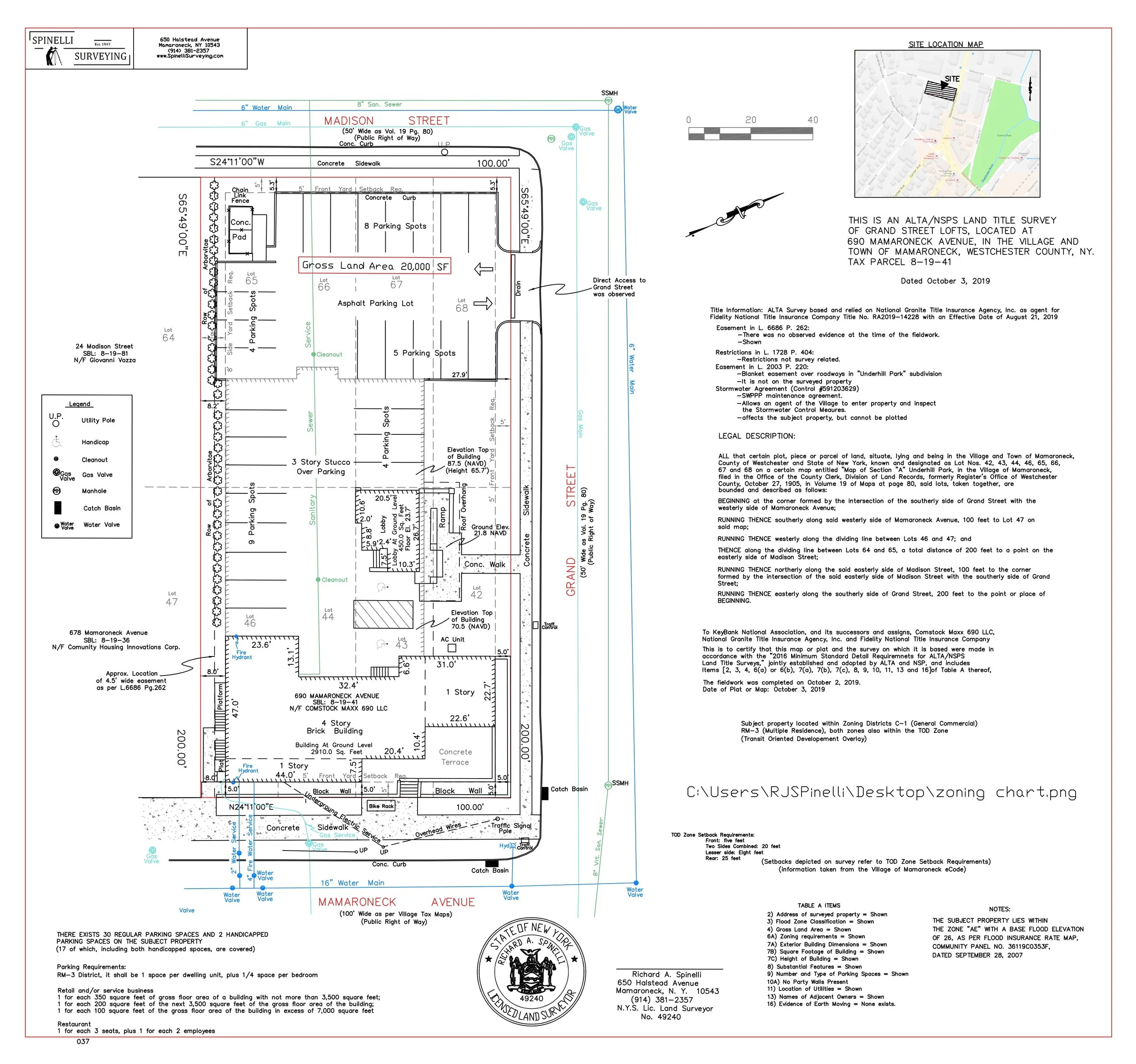
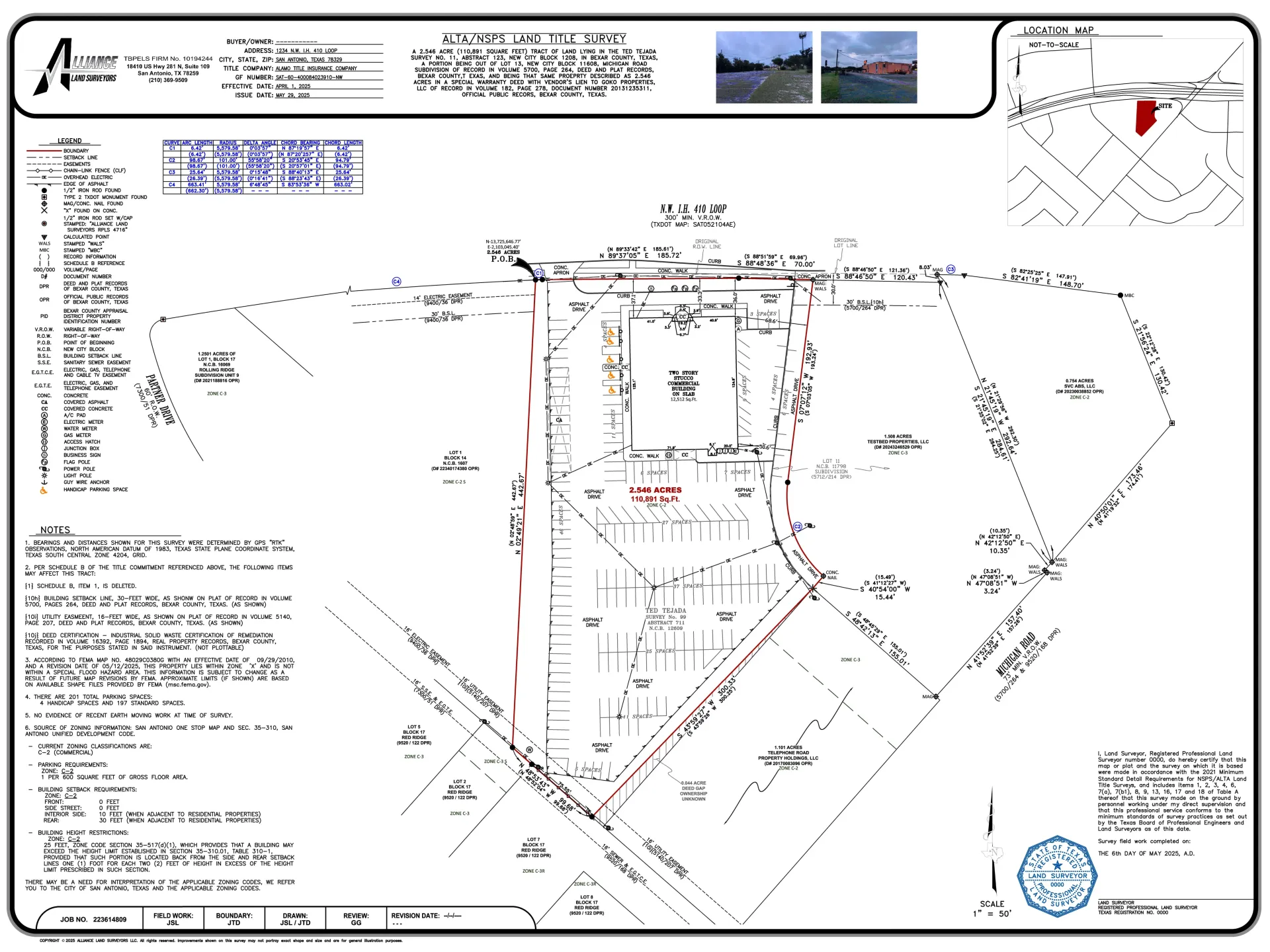
Table A of the ALTA/NSPS Land Title Survey is a checklist of optional technical responsibilities and data points that a client can request a surveyor to perform beyond the mandatory minimum standards. It allows lenders, developers, and attorneys to customize a land survey to meet specific transaction requirements, such as zoning analysis, utility location, or topographic data.
When conducting a commercial real estate transaction, a standard boundary survey is rarely sufficient. Lenders and title insurance companies require an ALTA/NSPS Land Title Survey, which adheres to strict national standards jointly established by the American Land Title Association (ALTA) and the National Society of Professional Surveyors (NSPS). While the "Minimum Standard Detail Requirements" define what must be in every survey, Table A represents the "a la carte" menu of additional items that provide a deeper level of due diligence.
As of 2026, the 2021 ALTA/NSPS standards remain the foundational framework for these surveys. Understanding which Table A items to select is critical for managing project costs, ensuring title insurance coverage, and identifying potential physical or legal encumbrances on a property.
The Relationship Between Minimum Standards and Table A
To understand Table A, one must first understand the baseline. The ALTA/NSPS standards require the surveyor to locate property boundaries, identify easements of record, show building locations, and note any observable evidence of use by third parties (such as paths or encroachments).
However, many commercial projects require more than just a map of the boundaries. A lender might need to know if the existing parking spaces meet municipal code, or a developer might need to know the exact location of underground gas lines before breaking ground. These requirements are not part of the "Minimum Standards." Instead, they are found in Table A.
Negotiating Table A items is a tripartite process involving the client (usually the buyer or developer), the lender, and the surveyor. Because each item in Table A requires additional field work, research, or office computation, each selection increases the cost and the turnaround time of the final survey product.
Detailed Breakdown of Table A Items (1 through 20)
The 2021 standards (currently active in 2026) consolidated and refined several items. Below is an explanation of the most significant items and why they are requested in modern real estate transactions.
1. Monuments and Markers
This item requires the surveyor to place permanent markers (monuments) at all property corners where they are missing. While the minimum standards require a surveyor to find existing monuments, Item 1 mandates the installation of new ones. This is essential for new developments where future construction will rely on clearly marked boundaries.
2. Address Information
The surveyor must show the municipal address of the property. While this seems simple, in large multi-parcel commercial tracts, addresses can be ambiguous. This item ensures that the physical location matches the legal description in the title commitment.
3. Flood Zone Classification
This is one of the most frequently requested items. The surveyor must research the Federal Emergency Management Agency (FEMA) flood maps and state the flood zone in which the property is located. If the property is in a Special Flood Hazard Area (SFHA), the survey will note the specific panel number and date of the map.
4. Gross Land Area
Standard surveys provide boundary dimensions. Item 4 requires the surveyor to calculate the total square footage or acreage of the land. This is vital for determining the purchase price if the deal is structured on a "per acre" basis, and for verifying compliance with zoning density requirements.
5. Vertical Relief (Topography)
Most ALTA surveys are 2D maps. Item 5 transforms the survey into a 3D representation by adding contour lines and elevation data. This is a high-cost item because it requires extensive field measurements, but it is indispensable for engineers who need to design drainage or foundation plans.
6. Zoning Information
Item 6 is arguably the most complex. It is divided into two parts:
- 6(a): The surveyor reports the current zoning classification, setbacks, and height restrictions based on a zoning report provided by the client.
- 6(b): The surveyor graphically depicts those setbacks and requirements on the map. It is important to note that surveyors are not zoning experts; they simply "map" the data provided to them. In 2026, many jurisdictions have complex "overlay districts," making this item essential for verifying that a building isn't in violation of local laws.
7. Exterior Building Dimensions and Square Footage
The minimum standards show where a building is; Item 7 requires the surveyor to measure the actual exterior footprint and calculate the total area. This helps lenders verify the "rentable square feet" mentioned in lease agreements.
8. Substantial Features and Improvements
This includes showing things like swimming pools, landscaped areas, and detached structures. It provides a more "pictorial" view of the property’s current state.
9. Number and Type of Parking Spaces
For retail and multi-family properties, parking is everything. This item requires the surveyor to count and label every parking space, including ADA-compliant (handicap) stalls. If the zoning requires 100 spaces and the survey only shows 90, the buyer has a major problem to resolve before closing.
10. Party Walls
If a building shares a wall with a neighboring property (common in urban settings), Item 10 requires the surveyor to determine if the wall is a "party wall" and show its relationship to the property line.
11. Underground Utilities
This is often the most misunderstood item. The surveyor is required to show evidence of utilities (manholes, valves, meters) and then use "source evidence" to show the underground lines. Source evidence typically includes:
- Plans provided by utility companies.
- Markings placed by "811" or private locators.
- Observed surface evidence. Surveyors do not dig up pipes; they report based on available records and visible markers.
12. Adjoining Property Owners
The surveyor lists the names of the owners of the parcels immediately adjacent to the surveyed property, typically sourced from current tax records.
13. Names of Adjoining Streets
This requires the surveyor to label the names of all public or private streets bordering the property and note the width of the right-of-way.
14. Distance to Nearest Intersection
Lenders use this to verify the property's access and location relative to the broader road network.
15. Use of Remote Sensing
This item acknowledges the use of drones (UAS), LiDAR, or satellite imagery in the creation of the survey. As of 2026, drone technology is standard, but Item 15 requires the surveyor to be transparent about the accuracy levels of these remote methods.
16. Recent Earthwork or Construction
If there are signs of recent grading or construction that aren't yet reflected in the title records, the surveyor must note them. This is a red flag for potential "mechanic's liens" (unpaid contractors).
17. Proposed Changes in Right-of-Way
If a municipality has a plan to widen the road in front of the property, the surveyor must show the proposed new property line. This could significantly impact future development or parking.
18. Off-site Easements
If the property benefits from an easement on a different piece of land (such as an access driveway through a neighbor's lot), Item 18 requires the surveyor to map that off-site area.
19. Professional Liability Insurance
The surveyor must provide proof that they carry a certain amount of professional liability insurance (errors and omissions). This protects the client if the surveyor makes a mistake that leads to financial loss.
20. Client-Defined Requirements
This is a "catch-all" bucket. If a lender has a very specific request that isn't covered in Items 1-19, it is negotiated here.
Summary Table of Key Table A Selections
The following table highlights the items most commonly requested by specific stakeholders in a transaction.
| Item Number | Description | Primary Requester | Impact on Cost/Time |
|---|---|---|---|
| 3 | Flood Zone | Lender / Insurer | Low |
| 4 | Land Area | Buyer / Developer | Low |
| 5 | Vertical Relief (Contours) | Engineer / Developer | High |
| 6 | Zoning Data | Buyer / Attorney | Moderate (Requires 3rd party report) |
| 8 | Substantial Features | Buyer | Moderate |
| 9 | Parking Count | Lender / Buyer | Moderate |
| 11 | Utilities | Developer / Engineer | High |
| 19 | Insurance Proof | Lender | Low |
Strategic Considerations for 2026 Transactions
In the 2026 real estate market, efficiency and risk mitigation are paramount. Choosing too many Table A items can lead to "scope creep," where the survey cost doubles and the delivery date is pushed back by weeks. Conversely, choosing too few can lead to "Table A Endorsement" denials from title companies.
The Zoning Dilemma (Item 6)
Item 6 is often the most contentious. Surveyors are increasingly hesitant to complete Item 6 without a formal Zoning Report from a specialized third-party provider. In 2026, municipal codes are more digital but also more layered. A client should expect to pay for both the survey and a separate zoning report to satisfy this requirement.
The Utility Challenge (Item 11)
Subsurface utility engineering (SUE) has advanced, but Item 11 remains a "best effort" task. Lenders often demand Item 11 to ensure there are no utility easements that would prevent building expansions. However, because 811 services often refuse to mark private property, the surveyor may need to hire a private locating firm, the cost of which is passed to the client.
Drone Integration (Item 15)
By 2026, drone-based photogrammetry has become the primary way surveyors capture large-scale site data. When selecting Item 15, clients should ensure the surveyor is using survey-grade GPS (RTK/PPK) to ensure that the "pretty picture" from the drone is also mathematically accurate to within centimeters.
Common Mistakes to Avoid
- Requesting "All Items": This is a common mistake made by junior paralegals. Requesting every item in Table A is almost never necessary and will lead to an astronomical quote. Focus on what the lender's "survey instructions" actually require.
- Missing the Title Commitment: A surveyor cannot complete an ALTA survey accurately without a current Title Commitment. They need to see the "Schedule B-II" exceptions to know which easements to plot.
- Ignoring Item 11 Limitations: Expecting the surveyor to find every abandoned underground tank or clay pipe is unrealistic. Item 11 is a mapping of available information, not a guarantee of total subterranean knowledge.
- Wait-and-See Approach: Waiting until two weeks before closing to order the survey is a recipe for disaster. If Item 5 (Topography) or Item 11 (Utilities) are selected, the surveyor may need 4 to 6 weeks to complete the field work and research.
Frequently Asked Questions
What is the most important Table A item for a lender?
The most important items for lenders are typically Item 3 (Flood Zone), Item 8 (Improvements), Item 9 (Parking), and Item 19 (Insurance). Lenders want to ensure the collateral for their loan is not at risk of flooding, has sufficient parking to remain commercially viable, and is covered by the surveyor's liability insurance.
Does the surveyor determine if the property is in compliance with zoning?
No. Under the ALTA/NSPS standards, the surveyor's role is to report the facts. They will state what the zoning code says (based on provided reports) and show the physical measurements of the property. The determination of whether those measurements constitute "compliance" or a "non-conforming use" is a legal conclusion usually handled by an attorney or a zoning consultant.
Can I add my own items to Table A?
Yes. Item 20 is specifically designed for "negotiated items." If you have a specific need—such as locating all trees over 6 inches in diameter or identifying evidence of environmental dump sites—you can define that requirement under Item 20. The surveyor will then provide a specific fee for that additional work.
How often do the ALTA/NSPS standards change?
Historically, the standards are updated every five to ten years. The last major update was in 2021. While minor tweaks occur, the core structure of Table A has remained relatively stable, though specific items are occasionally renumbered or combined to reduce ambiguity.
Why is Item 11 so expensive?
Item 11 is expensive because it involves significant liability and labor. The surveyor must contact various utility companies, wait for them to respond (which they are often slow to do for private property), and coordinate field crews to find and measure every visible piece of utility hardware. If a private locator is required, that adds a significant third-party cost.
Final Recommendation
When ordering an ALTA/NSPS Land Title Survey in 2026, start by obtaining the Lender's Survey Requirements document. This document acts as your roadmap. Do not blindly check every box in Table A; instead, match the boxes to the specific needs of your transaction. For most standard commercial acquisitions, a combination of Items 2, 3, 4, 8, 9, 13, and 19 provides a robust balance of due diligence and cost-efficiency. If construction or development is planned, adding Items 5 and 11 is essential. Always provide your surveyor with the title commitment and any available zoning reports as early as possible to avoid delays.