Airspace is the portion of the atmosphere controlled by a country above its territory, organized into a complex, three-dimensional grid designed to ensure the safety of all flight operations. In 2026, this system integrates traditional manned aircraft, unmanned aircraft systems (UAS), and emerging Advanced Air Mobility (AAM) platforms through specific classifications, equipment requirements, and communication protocols.
Understanding the National Airspace System (NAS) is essential for anyone operating in the skies, from commercial airline pilots to recreational drone hobbyists. The system is not merely "empty air" but a highly regulated environment where boundaries are defined by altitudes, lateral limits, and the type of activity permitted within them. This guide breaks down the nuances of airspace classification, special use areas, and the regulatory requirements for 2026.
The Two Fundamental Categories: Controlled vs. Uncontrolled
At its most basic level, airspace is divided into two categories: controlled and uncontrolled. The distinction determines whether a pilot must interact with Air Traffic Control (ATC) and what level of equipment is required on the aircraft.
Controlled Airspace
Controlled airspace is a generic term that covers the different classifications of airspace and defined dimensions within which ATC service is provided. In these areas, aircraft operators are subject to certain pilot qualifications, equipment requirements, and operating rules. As of 2026, the density of traffic in controlled airspace—driven by an increase in commercial drone deliveries and urban air taxis—has made strict adherence to these rules more critical than ever.
Uncontrolled Airspace
Uncontrolled airspace, designated as Class G, is the portion of the air where ATC has no authority or responsibility for controlling air traffic. However, pilots are still bound by Federal Aviation Regulations (FARs) regarding visual flight rules (VFR) and safety. While ATC does not issue "clearances" in Class G, they may provide flight following services if their workload permits.
Decoding the Alphabet: Classes A, B, C, D, E, and G
The International Civil Aviation Organization (ICAO) and the Federal Aviation Administration (FAA) use a lettered system to classify airspace. Each letter represents a different set of rules and environmental conditions.
Class Alpha (A): High-Altitude Highways
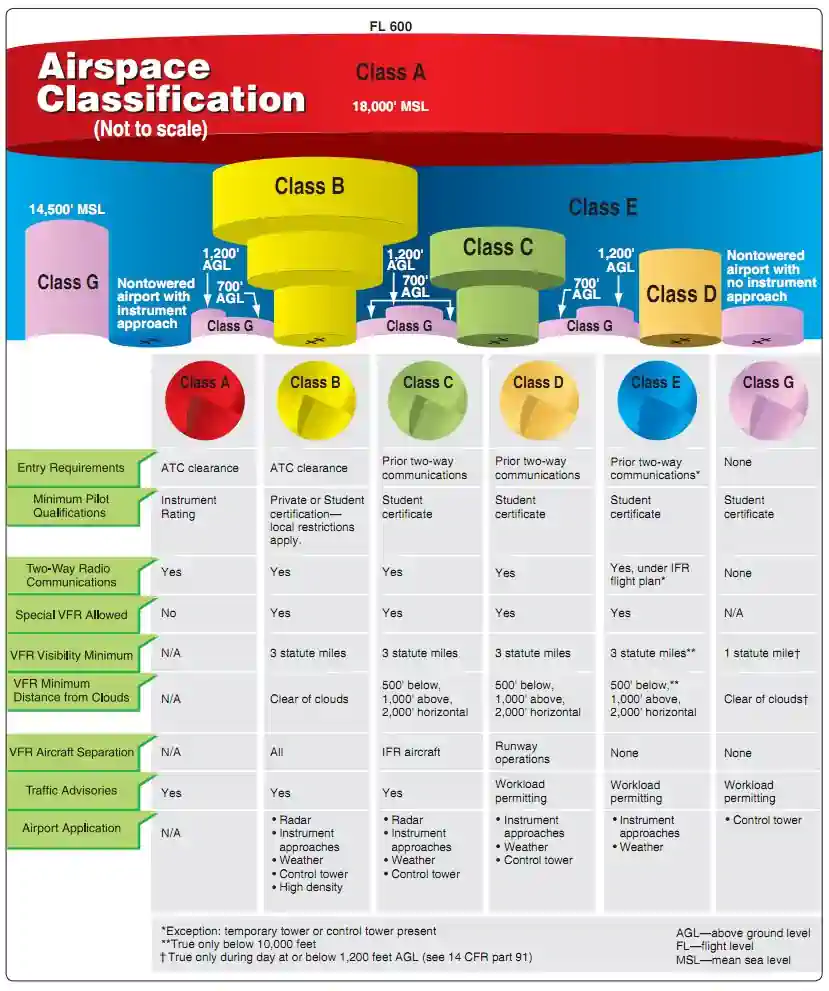
Class A airspace extends from 18,000 feet Mean Sea Level (MSL) up to and including Flight Level 600 (approximately 60,000 feet).
- Operations: All flight operations in Class A must be conducted under Instrument Flight Rules (IFR).
- Requirements: Pilots must be IFR rated, and the aircraft must be equipped for IFR flight, including a Mode C or Mode S transponder and ADS-B Out.
- Entry: A specific ATC clearance is required to enter. There is no VFR flight permitted in Class A; this ensures that high-speed jet traffic is always separated by professional controllers.
Class Bravo (B): Major Hubs
Class B airspace is designed to protect the nation's busiest airports, such as Hartsfield-Jackson Atlanta International or Dubai International. It is often described as an "upside-down wedding cake," with layers that get wider as altitude increases.
- Dimensions: Individually tailored, but typically extends from the surface to 10,000 feet MSL.
- Requirements: To enter, a pilot must receive a specific clearance ("Cleared into the Class Bravo airspace"). The aircraft must have a two-way radio and ADS-B Out capability.
- Drone Operations: Remote pilots must obtain prior authorization via LAANC (Low Altitude Authorization and Notification Capability) or the FAA DroneZone.
Class Charlie (C): Regional Airports
Class Charlie covers airports that are busy but do not reach the volume of Class B hubs. They typically have a 5-nautical mile (NM) inner core extending from the surface to 4,000 feet Above Ground Level (AGL) and a 10-NM outer shelf from 1,200 feet to 4,000 feet AGL.
- Entry: Unlike Class B, you do not need an explicit "clearance" to enter, but you must establish two-way radio communication. If the controller responds with your aircraft's tail number, communication is established.
- Equipment: Two-way radio and ADS-B Out are mandatory.
Class Delta (D): Smaller Towered Airports
Class Delta airspace is generally a cylinder extending from the surface to 2,500 feet AGL around airports with an operational control tower but no radar service (or limited service).
- Dimensions: Usually a 4-NM radius.
- Entry: Two-way radio communication must be established prior to entry. Once the tower closes for the night, Class D airspace often reverts to Class E or Class G.
Class Echo (E): The "Catch-All" Airspace
Class Echo is controlled airspace that is not A, B, C, or D. It is the most abundant type of controlled airspace.
- Purpose: It provides a corridor for IFR aircraft to transition from the en-route environment to the terminal environment.
- Altitudes: In most of the United States, Class E begins at either 700 feet AGL or 1,200 feet AGL and extends up to (but not including) 18,000 feet MSL. It also exists above FL600.
- Requirements: No specific clearance or radio communication is required for VFR flight, but IFR aircraft are fully controlled.
Class Golf (G): The Unregulated Frontier
Class Golf is the only category of uncontrolled airspace. It typically exists from the surface up to the floor of the overlying Class E airspace. In 2026, Class G remains the primary domain for recreational drone flights and rural general aviation, though it is shrinking in some areas to accommodate new commercial flight corridors.
Airspace Requirements Comparison Table
| Airspace Class | ATC Clearance Required | Two-Way Radio Required | Minimum Pilot Certificate | Minimum Equipment (2026) |
|---|---|---|---|---|
| Class A | Yes | Yes | Instrument Rating | ADS-B Out / Transponder |
| Class B | Yes | Yes | Private (or Student w/ Endorsement) | ADS-B Out / Transponder |
| Class C | Communication Only | Yes | Student Pilot | ADS-B Out / Transponder |
| Class D | Communication Only | Yes | Student Pilot | Two-way Radio |
| Class E | No (for VFR) | No (for VFR) | Student Pilot | ADS-B Out (where applicable) |
| Class G | No | No | Student Pilot | None (generally) |
Special Use Airspace: Areas of Restriction
Beyond the standard lettered classes, the NAS contains "Special Use Airspace" where flight activity must be confined or where limitations are imposed on aircraft not participating in those activities.
- Prohibited Areas (P): Flight is strictly forbidden for security or national welfare reasons (e.g., The White House or Camp David).
- Restricted Areas (R): These areas contain "unusual, often invisible, hazards" such as artillery firing or guided missiles. While not always prohibited, you must have permission from the controlling agency to enter when the area is "active."
- Warning Areas (W): Similar to restricted areas, but located over domestic or international waters. They warn non-participating pilots of potential danger.
- Military Operations Areas (MOA): These separate military training activities from IFR traffic. VFR pilots can legally fly through them but are encouraged to exercise extreme caution and contact the controlling agency for activity status.
- Alert Areas (A): Areas with a high volume of pilot training or unusual aerial activity. No permission is needed, but all pilots are responsible for collision avoidance.
- Controlled Firing Areas (CFA): Activities are suspended immediately if a spotter aircraft or radar indicates an aircraft is approaching. These are not depicted on aeronautical charts because they do not burden the pilot to change course.
Visual Flight Rules (VFR) Weather Minimums
A critical part of "airspace explained" is understanding the weather conditions required to fly in each class without an IFR clearance. These rules ensure that pilots flying "see and avoid" have enough visibility to spot other traffic and enough distance from clouds to allow an IFR aircraft exiting a cloud to see them.
- Class B: 3 statute miles (SM) visibility and "Clear of Clouds."
- Class C, D, and E (below 10,000' MSL): 3 SM visibility, 500 feet below, 1,000 feet above, and 2,000 feet horizontal from clouds (the "3-152" rule).
- Class E (at or above 10,000' MSL): 5 SM visibility, 1,000 feet below, 1,000 feet above, and 1 SM horizontal from clouds (the "5-111" rule).
In 2026, these visibility requirements remain the gold standard for safety, even as augmented reality (AR) cockpits become more common in light aircraft.
The 2026 Perspective: Drones and Advanced Air Mobility
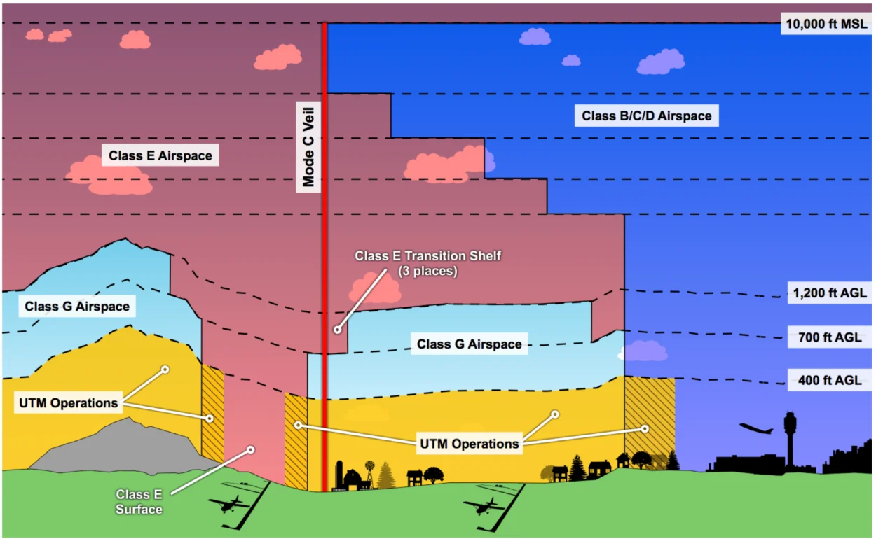
The airspace landscape has evolved significantly by 2026. The integration of Unmanned Aircraft System Traffic Management (UTM) has created a digital layer on top of traditional airspace.
LAANC and Instant Authorization
For drone operators (Part 107 or Recreational), Class B, C, and D airspace are no longer "no-fly zones." Through the LAANC system, pilots can receive near-instant digital authorization to fly in controlled airspace up to certain altitudes (depicted on UAS Facility Maps). This automated system coordinates with ATC to ensure that drones do not interfere with manned arrivals and departures.
Remote ID
In 2026, Remote ID is fully implemented and mandatory for almost all drones. This "digital license plate" broadcasts the drone's position and identity, allowing security agencies and ATC to monitor the airspace in real-time. This technology has paved the way for "Beyond Visual Line of Sight" (BVLOS) operations, which are now common in Class G and Class E airspace for medical deliveries and infrastructure inspection.
TFRs: Temporary Flight Restrictions
Pilots must also be aware of Temporary Flight Restrictions (TFRs). These are issued via a NOTAM (Notice to Air Missions) and can be triggered by sporting events, presidential movement, or natural disasters like wildfires. In 2026, TFRs are updated in real-time on electronic flight bags (EFBs) like ForeFlight and Garmin Pilot, making it easier for pilots to avoid accidental incursions.
Frequently Asked Questions
Does airspace start at the ground everywhere?
No. While Class B, C, and D typically start at the surface, Class E often starts at 700 feet or 1,200 feet AGL. Below that is Class G (uncontrolled) airspace. This allows small aircraft and drones to operate in rural areas without constant ATC interaction.
What happens if I accidentally enter controlled airspace?
An unauthorized incursion into Class B or Restricted airspace is a serious safety violation. ATC will likely ask you to call a phone number upon landing for a "Pilot Deviation" investigation. In 2026, automated tracking (ADS-B and Remote ID) makes it nearly impossible for incursions to go unnoticed.
Why is Class E called "controlled" if I don't need to talk to anyone?
It is "controlled" because Air Traffic Control provides separation services for aircraft flying under IFR. VFR pilots can fly there without talking to ATC, but they must follow specific weather minimums to ensure they are visible to the IFR traffic that ATC is managing.
Can drones fly in Class A airspace?
Generally, no. Class A is reserved for high-altitude IFR traffic (18,000'+). While some specialized high-altitude long-endurance (HALE) drones operate there, they require specific FAA waivers and advanced transponder equipment.
How do I know what airspace I am in right now?
The most reliable way is to use a current Sectional Chart or an Electronic Flight Bag (EFB). These maps use color-coded lines (blue, magenta, dashed, or solid) to indicate the boundaries and altitudes of each airspace class.
Practical Recommendations for Navigating Airspace
To stay safe and legal in the 2026 aviation environment, follow these steps:
- Use Modern Tools: Utilize EFBs like ForeFlight or SkyVector for manned flight, and FAA-approved UTM apps (like Aloft or AirControl) for drone operations.
- Check NOTAMs: Always check for Temporary Flight Restrictions before every flight. A TFR can appear and disappear within hours.
- Understand Your Equipment: Ensure your ADS-B Out is functioning and your Remote ID (for drones) is broadcasting correctly. In 2026, equipment failure in controlled airspace often necessitates an immediate landing or exit from the area.
- Prioritize Communication: If you are unsure of your position or the airspace status, contact the nearest Approach Control or Flight Service Station (FSS). ATC is there to help, and proactive communication can prevent a legal violation.
By mastering the layers and rules of the sky, pilots and operators ensure that the National Airspace System remains the safest and most efficient in the world.