Amerigo Vespucci is historically significant for his documentation of the South American coastline between 1497 and 1504, providing the first European recognition that these lands constituted a distinct "Mundus Novus," or New World, rather than the outskirts of Asia. His voyages covered the coastal regions of modern-day Brazil, Uruguay, and Argentina, fundamentally shifting global cartographic understanding.
The Context of the Age of Discovery
To understand the areas explored by Amerigo Vespucci, one must first recognize the prevailing European geopolitical landscape of the late 15th century. Spain and Portugal were engaged in a fierce race to secure maritime trade routes to the East Indies. Following the 1492 voyage of Christopher Columbus, there was a persistent, though increasingly contested, belief that the lands reached across the Atlantic were part of the Asian mainland.
Vespucci, a Florentine merchant and navigator, transitioned from a commercial background into the role of a maritime explorer. His contribution was not merely the act of navigation, but the systematic documentation and conceptualization of the geography he encountered. Unlike earlier explorers who were often focused on finding the quickest path to gold or spices, Vespucci’s accounts—most notably those detailed in his letters Mundus Novus and Quattuor Americi Vespuctii Navigationes—prioritized the scientific observation of flora, fauna, and human geography.
The First Voyage: Questioning the Map (1497–1498)
The details of Vespucci’s first voyage remain a subject of rigorous historical debate among scholars. According to his letters, he departed from Spain in May 1497, heading across the Atlantic to the coast of what is now Honduras and Mexico. He traveled along the coastline of the Gulf of Mexico and eventually north toward the Florida peninsula.
If this voyage occurred as described, it would represent the first European contact with the North American mainland since the Norse expeditions. However, many historians remain skeptical, arguing that the accounts may have been retroactively fabricated to establish a claim of priority over other explorers. Despite this scholarly friction, the regions described in this expedition set the stage for his subsequent, better-documented southern voyages.
The Second Voyage: Scouting the South American Coast (1499–1500)
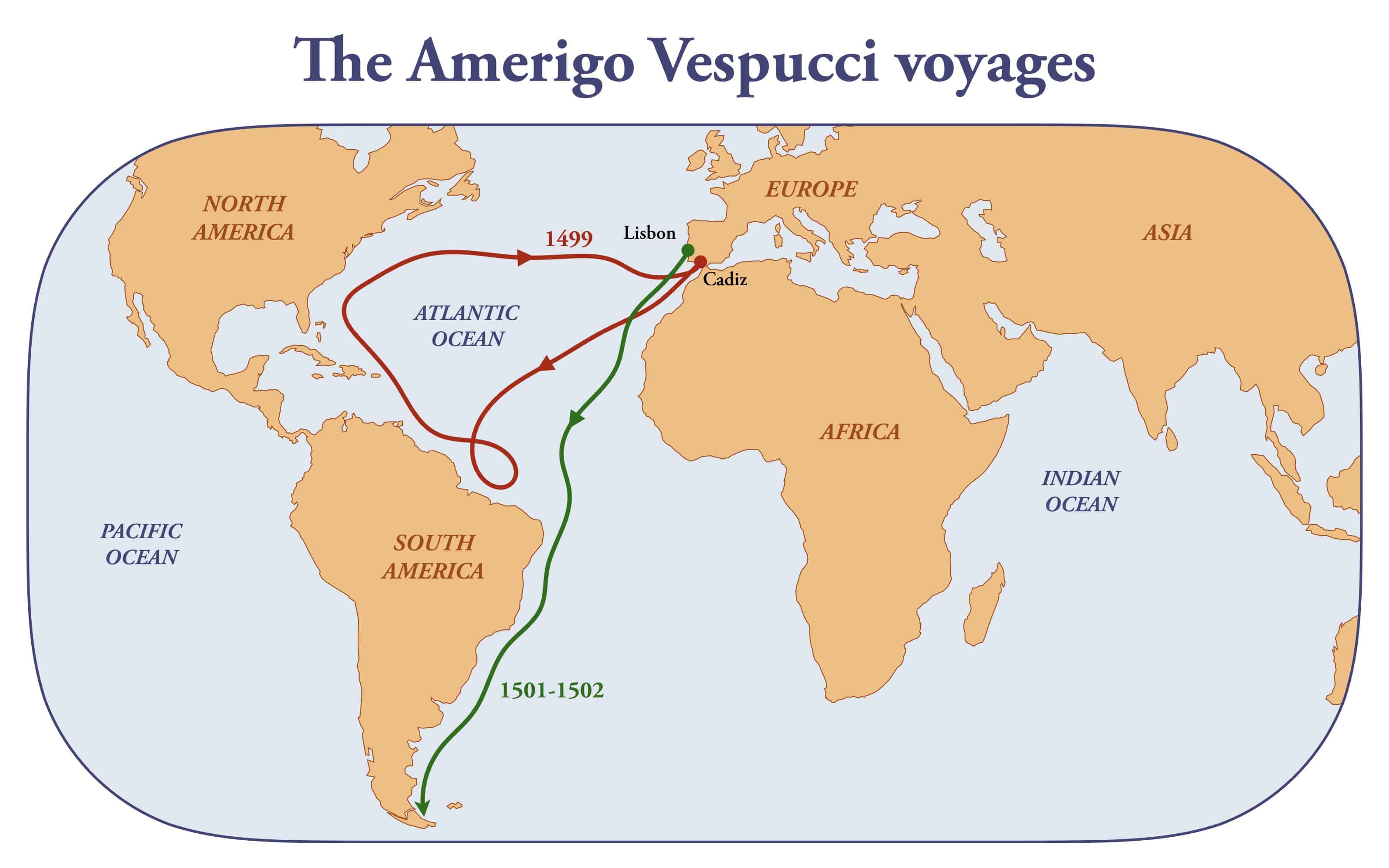
In 1499, sailing under the Spanish flag with Alonso de Ojeda, Vespucci reached the coast of present-day Guyana and Suriname. The expedition proceeded to move southeast, systematically charting the coastline. It was during this journey that Vespucci witnessed the massive volume of fresh water pouring into the ocean from the Amazon River.
Recognizing the scale of this discharge, he deduced that such a massive freshwater output could only originate from a landmass of continental proportions—far larger than any island chain associated with the Asian coast. He spent significant time surveying the coast of Brazil, essentially mapping the northeastern shelf of the South American continent. This voyage proved essential in differentiating the geography of the southern Atlantic from the expected maritime geography of the Far East.
The Third and Fourth Voyages: The "New World" Realization (1501–1504)
The most critical expeditions regarding geographic theory occurred while Vespucci was in the service of the King of Portugal. Departing in 1501, his fleet explored the Brazilian coastline, traveling much further south than his previous Spanish-led efforts. By the time the expedition reached the region of modern-day Rio de Janeiro, they were firmly in waters that no other European had formally recorded.
As the ships pushed into the temperate regions of the South Atlantic—reaching as far south as the estuary of the Río de la Plata, between modern-day Uruguay and Argentina—Vespucci realized the land mass continued indefinitely to the south. This observation was the final catalyst for his conclusion that these territories formed an entirely separate continent. He began referring to these regions as Mundus Novus.
The fourth voyage in 1503, while less extensive in terms of new territory, allowed him to consolidate his notes. By this time, his letters were being circulated throughout Europe. The publication of these findings allowed cartographers, most notably Martin Waldseemüller, to formalize the existence of a fourth continent, eventually naming it "America" in his honor in 1507.
Comparative Summary of Expeditions
The following table outlines the approximate regions covered during his documented or reported travels, highlighting the transition in scope during his maritime career.
| Voyage | Sponsor | Primary Area Explored | Geographic Impact |
|---|---|---|---|
| First (1497–98) | Spain | Central American/Gulf Coast | Controversial documentation of the northern coast. |
| Second (1499–00) | Spain | Northern South America (Guyana/Brazil) | Discovery of the Amazon River outflow. |
| Third (1501–02) | Portugal | Eastern South America (Brazil to Argentina) | Confirmation of a massive southern landmass. |
| Fourth (1503–04) | Portugal | Brazilian coast | Refinement of coastal charts and observations. |
Intellectual Contributions and Cartographic Legacy
It is important to distinguish between "exploring" in the sense of first contact and "exploring" in the sense of intellectual classification. While other explorers may have technically sailed by certain coastlines earlier, Vespucci was unique in his analytical approach. He utilized celestial navigation methods—specifically calculating the distance of the moon from planets—to estimate longitudinal position, a highly complex task for the period.
His accounts provided the descriptive detail that allowed European mapmakers to break free from the Ptolemaic view of the world. By 1507, the Waldseemüller map used the term "America" to designate the lands in the western hemisphere. This choice was based directly on the Latin version of his name, Americus Vespucius. While the inclusion of the name remains a historical point of contention regarding the roles of Columbus versus Vespucci, the geographic reality that Vespucci defined—the existence of a landmass distinct from Asia—remains his enduring contribution.
Scientific and Anthropological Observations
Beyond the physical mapping of coastlines, Vespucci’s exploration was characterized by a focus on the "human geography" of the regions. He documented the languages, social structures, and agricultural practices of the indigenous peoples he encountered. His descriptions of the flora and fauna were similarly detailed, providing European naturalists with their first glimpses of the unique biodiversity of the South American continent.
These observations were widely disseminated through the printing press, which was a nascent but powerful technology in the early 1500s. The accessibility of these printed accounts meant that the concept of a "New World" spread rapidly through the intellectual circles of Renaissance Europe. This shifted the focus of European ambition from a strictly trade-based interest in Asian routes to an interest in the colonization and study of these vast, newly recognized lands.
Challenges and Limitations of His Expeditions
Exploration in the early 16th century was fraught with extreme risk. The ships of the era were not equipped for long-term survival in variable climates ranging from the tropical heat of the Amazon basin to the rugged, cold waters of the South Atlantic. Navigation was subject to high margins of error, and the lack of reliable chronometers meant that longitudinal calculations, though innovative for the time, were approximations.
Furthermore, the relationship with indigenous populations was often strained, creating significant operational hurdles for any landing party attempting to survey inland or replenish water and food supplies. Vespucci’s survival through these expeditions highlights the limitations of his vessels and the high stakes involved in mapping unknown, expansive coastlines. These practical difficulties explain why his maps remained broad in scope rather than granular in internal detail.
Frequently Asked Questions
Did Amerigo Vespucci personally map the entire coast of South America? No. Vespucci explored and charted significant portions of the northern and eastern coastlines of South America, specifically those belonging to modern-day Guyana, Brazil, Uruguay, and Argentina. His efforts, combined with reports from other contemporaneous navigators, contributed to the broader map of the continent.
Why is he credited with identifying the "New World"? Vespucci was the first European to formally articulate in writing that the lands discovered in the west were not the Asian mainland but a distinct, separate landmass. His letters, published and widely read, influenced cartographers to delineate this area as a separate continent on world maps.
What specific region did he explore that convinced him it wasn't Asia? The coastal regions of Brazil and the South Atlantic (specifically the area near the Río de la Plata) provided the evidence. The vast distance of the coastline and the sheer volume of the Amazon River discharge led him to conclude that such geographic features could only exist on a massive, independent continent.
Are there historical doubts regarding his voyages? Yes. Historians frequently debate the authenticity of the first voyage in 1497. Some scholars suggest the accounts of this specific expedition may have been embellished or misdated to bolster Vespucci’s reputation as an explorer of priority. However, his voyages for Portugal (1501–1504) are well-documented and historically accepted.
How did he measure his position without modern technology? Vespucci used celestial navigation, particularly the lunar distance method. By measuring the angle between the moon and specific stars or planets, he could estimate his longitude relative to a known point. While primitive by modern standards, it was an advanced technical skill for the period.
Practical Next Steps for Researchers
For those interested in further examining the legacy of these expeditions, the primary sources remain the most reliable starting point. Academic repositories often provide high-resolution digital scans of the original letters and the 1507 Waldseemüller map. When researching this period, it is recommended to prioritize translations of Mundus Novus that provide critical commentary, as the linguistic nuances of the early 16th-century Italian and Latin manuscripts can significantly alter the interpretation of his findings.
If you are investigating the exact routes, seek out modern cartographic reconstructions that overlay Vespucci’s reported logs onto contemporary satellite imagery. This method allows researchers to visualize the delta of the Amazon and the southern coastal geography as they appeared to the explorer, bridging the gap between historical narrative and modern physical reality.