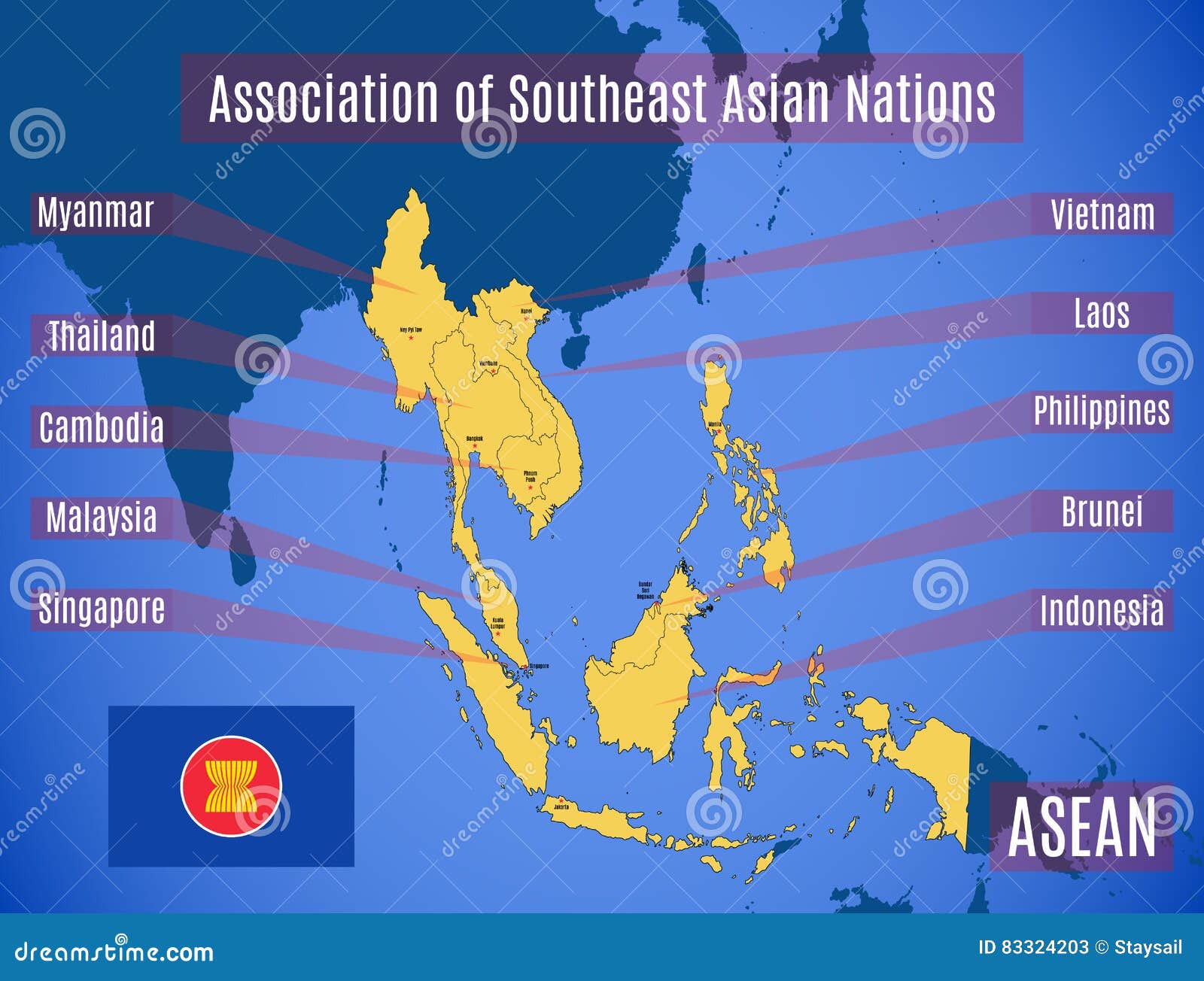
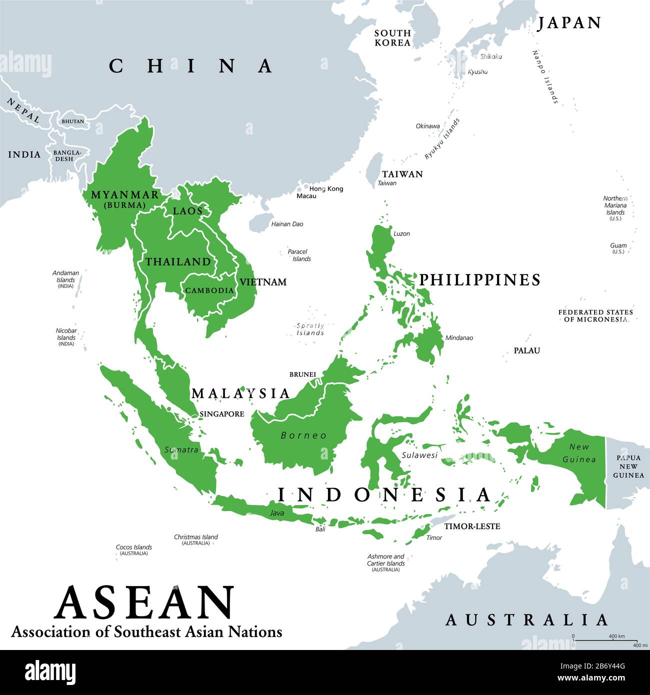
A map of ASEAN countries includes the ten permanent members of the Association of Southeast Asian Nations: Brunei, Cambodia, Indonesia, Laos, Malaysia, Myanmar, the Philippines, Singapore, Thailand, and Vietnam. It also identifies Timor-Leste as an official observer in the final stages of full membership accession as of 2026.
The Association of Southeast Asian Nations (ASEAN) represents one of the most diverse and economically dynamic regions on Earth. Stretching across more than 4.5 million square kilometers, the ASEAN map covers a vast area that bridges the Indian and Pacific Oceans. Understanding this map requires more than just identifying borders; it involves recognizing the distinction between mainland and maritime Southeast Asia, the strategic importance of various waterways, and the evolving political status of neighboring territories.
The Composition of the ASEAN Map
The current ASEAN map is defined by its ten core member states, which joined the organization at different intervals since its founding in 1967. Historically, the "ASEAN-5" (Indonesia, Malaysia, Philippines, Singapore, and Thailand) established the bloc, with others joining throughout the 1980s and 1990s. As of 2026, the map is often viewed through the lens of the ASEAN Economic Community (AEC), which emphasizes regional integration and connectivity.
The Ten Permanent Member States
- Brunei Darussalam: Located on the northern coast of the island of Borneo. It is surrounded by the Malaysian state of Sarawak and faces the South China Sea.
- Cambodia: Situated in the southern portion of the Indochinese Peninsula, bordered by Thailand, Laos, and Vietnam, with a coastline along the Gulf of Thailand.
- Indonesia: The world’s largest archipelagic state, consisting of over 17,000 islands. It spans from the tip of Sumatra in the west to the border of Papua New Guinea in the east.
- Laos: The only landlocked country in the ASEAN bloc. It shares borders with Myanmar, China, Vietnam, Cambodia, and Thailand.
- Malaysia: Geographically split into two parts by the South China Sea: Peninsular Malaysia (bordering Thailand and Singapore) and East Malaysia (on the island of Borneo).
- Myanmar (Burma): The largest country in mainland Southeast Asia, sharing borders with India, Bangladesh, China, Laos, and Thailand.
- Philippines: An archipelago of 7,641 islands located in the western Pacific Ocean, north of Indonesia and east of Vietnam.
- Singapore: A diamond-shaped island nation located at the southern tip of the Malay Peninsula, separated from Malaysia by the Straits of Johor.
- Thailand: Centrally located in the Indochinese Peninsula, it serves as the primary land gateway between the northern and southern parts of the region.
- Vietnam: An S-shaped country on the eastern edge of mainland Southeast Asia, featuring an extensive coastline along the South China Sea.
The Status of Timor-Leste
In 2026, maps of the ASEAN region increasingly include Timor-Leste (East Timor). Following the 2022 agreement in principle to admit the nation, Timor-Leste has been operating under a strict roadmap toward full membership. While it maintains observer status, it participates in high-level summits, and its geographic location at the eastern end of the Lesser Sunda Islands makes it an integral part of the regional maritime map.
Geographic Divisions: Mainland vs. Maritime Southeast Asia
To analyze a map of ASEAN countries effectively, geographers typically divide the region into two distinct sub-regions. These divisions are not just based on landmass types but also reflect historical trade patterns, climates, and ecological systems.
Mainland Southeast Asia (The Indochinese Peninsula)
Mainland Southeast Asia consists of Cambodia, Laos, Myanmar, Thailand, and Vietnam. This region is characterized by high mountain ranges in the north (extensions of the Himalayas) and large river systems that flow southward. The Mekong River is the lifeblood of this area, snaking through nearly all mainland ASEAN nations and acting as a vital corridor for transport, irrigation, and energy.
The mainland map is marked by fertile alluvial plains and deltas, particularly the Chao Phraya in Thailand and the Red River and Mekong Deltas in Vietnam. These areas are the agricultural heartlands of the region, making the mainland a global hub for rice production.
Maritime Southeast Asia (The Malay Archipelago)
Maritime Southeast Asia includes Brunei, Indonesia, Malaysia, the Philippines, and Singapore. This region is defined by its archipelagic nature and its position along some of the world’s busiest maritime trade routes.
The geography here is dominated by the seas: the South China Sea, the Java Sea, the Celebes Sea, and the Sulu Sea. These nations are part of the "Ring of Fire," resulting in a landscape of volcanic peaks and lush tropical rainforests. The Strait of Malacca, located between Peninsular Malaysia and Sumatra (Indonesia), is the most critical chokepoint on the ASEAN map, facilitating nearly 25% of global sea-based trade.
Key Geographic Data and Indicators (2026 Estimates)
The following table provides a snapshot of the ASEAN member states, helping to contextualize the map with demographic and administrative data.
| Country | Capital City | Total Land Area (sq km) | Estimated Population (2026) | Currency |
|---|---|---|---|---|
| Brunei | Bandar Seri Begawan | 5,765 | 465,000 | Brunei Dollar (BND) |
| Cambodia | Phnom Penh | 181,035 | 17,600,000 | Riel (KHR) |
| Indonesia | Nusantara* | 1,904,569 | 282,000,000 | Rupiah (IDR) |
| Laos | Vientiane | 236,800 | 7,900,000 | Kip (LAK) |
| Malaysia | Kuala Lumpur | 329,847 | 35,200,000 | Ringgit (MYR) |
| Myanmar | Naypyidaw | 676,578 | 55,100,000 | Kyat (MMK) |
| Philippines | Manila | 300,000 | 119,500,000 | Peso (PHP) |
| Singapore | Singapore | 734 | 6,100,000 | Singapore Dollar (SGD) |
| Thailand | Bangkok | 513,120 | 71,800,000 | Baht (THB) |
| Vietnam | Hanoi | 331,210 | 101,200,000 | Dong (VND) |
*Note: As of 2026, the Indonesian government has completed the primary phases of relocating its administrative capital from Jakarta to Nusantara in East Kalimantan.
Strategic Waterways and Borders
A map of ASEAN countries is often a map of water. The region’s geopolitics are heavily influenced by its maritime boundaries and the international laws governing them, such as the United Nations Convention on the Law of the Sea (UNCLOS).
The South China Sea
The South China Sea is the most prominent water body on the ASEAN map. It is bordered by Brunei, Malaysia, the Philippines, and Vietnam. Because it contains critical shipping lanes and potential oil and gas reserves, it is a site of overlapping territorial claims. These claims are often represented on maps by various "lines," such as the exclusive economic zones (EEZs) of the respective ASEAN states.
The Mekong River Basin
For the mainland countries, the Mekong River serves as a natural border in several places, particularly between Thailand and Laos. The management of the river is a central theme in regional cooperation, as dam construction and water usage upstream affect the ecological health and food security of nations downstream.
Land Borders and Cross-Border Economic Zones
ASEAN maps also highlight specific "Growth Triangles" or cross-border economic zones. One of the most famous is the SIJORI Growth Triangle, which links Singapore, Johor (Malaysia), and the Riau Islands (Indonesia). These areas represent the map's functional reality, where borders are porous for trade and labor, even if they remain distinct politically.
Infrastructure and Connectivity: The Digital and Physical Map
In 2026, the concept of a "map" of ASEAN has expanded to include connectivity networks. The ASEAN Master Plan on Connectivity 2025 has transitioned into new frameworks aimed at integrating the region’s physical and digital infrastructure.
The ASEAN Highway Network (AHN)
This is a coordinated effort to link all mainland and maritime (via ferries) ASEAN countries through a standardized road system. On a modern map, the AHN appears as a web of primary and secondary routes designed to facilitate trucking and tourism from Singapore all the way to the northern reaches of Myanmar and Vietnam.
High-Speed Rail Corridors
By 2026, several high-speed rail projects have significantly altered the "time-distance" map of Southeast Asia. The Laos-China railway is fully operational, and progress on the Pan-Asia Railway network continues to bridge the gap between Bangkok and Kunming, China, effectively linking ASEAN more closely with the rest of the Asian landmass.
Maritime Port Integration
The map is dotted with "Super Ports." Singapore remains the primary transshipment hub, but significant expansions in Vietnam’s Hai Phong and Indonesia’s Patimban ports have redistributed the flow of goods across the regional map. These ports serve as the primary nodes connecting ASEAN to the global supply chain.
Challenges in Mapping the Region
While a standard political map shows clear lines, the reality of the ASEAN map involves several complexities.
- Disputed Territories: Beyond the South China Sea, there are minor land border disputes and maritime boundary overlaps that remain subject to bilateral negotiations. Maps produced by different member states may occasionally reflect slightly different maritime boundaries.
- Archipelagic Navigation: For countries like Indonesia and the Philippines, mapping internal waters is a matter of national sovereignty. The concept of "archipelagic sea lanes" is vital for ensuring international transit rights while protecting the security of the island nations.
- Climate Change Impacts: As of 2026, environmental mapping has become crucial. Rising sea levels are physically altering the coastlines of low-lying areas like the Mekong Delta and the coastal regions of Jakarta and Manila. Modern maps often include "vulnerability layers" to help regional planners address these changes.
Frequently Asked Questions
Which ASEAN country is the largest by land area?
Indonesia is by far the largest country in ASEAN, covering approximately 1.9 million square kilometers of land. It accounts for nearly 40% of the total landmass of the entire Southeast Asian region and stretches across three time zones.
Is Timor-Leste officially on the map of ASEAN countries?
As of 2026, Timor-Leste is considered an "ASEAN Member-in-waiting" or an official observer. While it is not yet a full voting member of every ASEAN council, it is geographically part of the Southeast Asian region and is included in all official ASEAN maps and regional planning initiatives.
Does the ASEAN map include any landlocked countries?
Yes, Laos is the only landlocked country in the ASEAN bloc. Because it lacks direct access to the sea, Laos has focused on becoming a "land-linked" nation, positioning itself as a central transit hub for power and rail connectivity between its neighbors.
What are the main bodies of water surrounding the ASEAN region?
The region is surrounded by the Pacific Ocean to the east and the Indian Ocean to the west. Key internal and adjacent water bodies include the South China Sea, the Andaman Sea, the Gulf of Thailand, the Java Sea, and the Celebes Sea.
How has the capital city of Indonesia changed on the 2026 map?
On maps produced in or after 2026, the capital of Indonesia is officially marked as Nusantara, located in the province of East Kalimantan on the island of Borneo. While Jakarta remains the largest city and a primary economic hub, administrative functions have shifted to the new capital site.
Are there any countries in Southeast Asia that are not in ASEAN?
Currently, all countries geographically located within Southeast Asia are either members (10) or observers (Timor-Leste). While Papua New Guinea holds observer status in ASEAN, it is technically classified as part of Oceania (Melanesia), though it maintains very close diplomatic ties with the bloc.
Practical Recommendation for Researchers and Travelers
When using or creating a map of ASEAN countries in 2026, it is essential to use updated cartographic data that reflects the most recent infrastructure developments and political shifts. For business and logistical planning, focus on the ASEAN Power Grid and the ASEAN Highway Network layers, as these represent the true integration of the region beyond simple political borders.
For travelers, the most useful maps are those that highlight the "ASEAN Single Aviation Market" hubs, which allow for seamless travel between major capitals like Bangkok, Singapore, and Jakarta. Always verify the status of land borders in Myanmar and the southern Philippines, as localized security situations can occasionally affect trans-border travel despite the official openness suggested by regional maps.