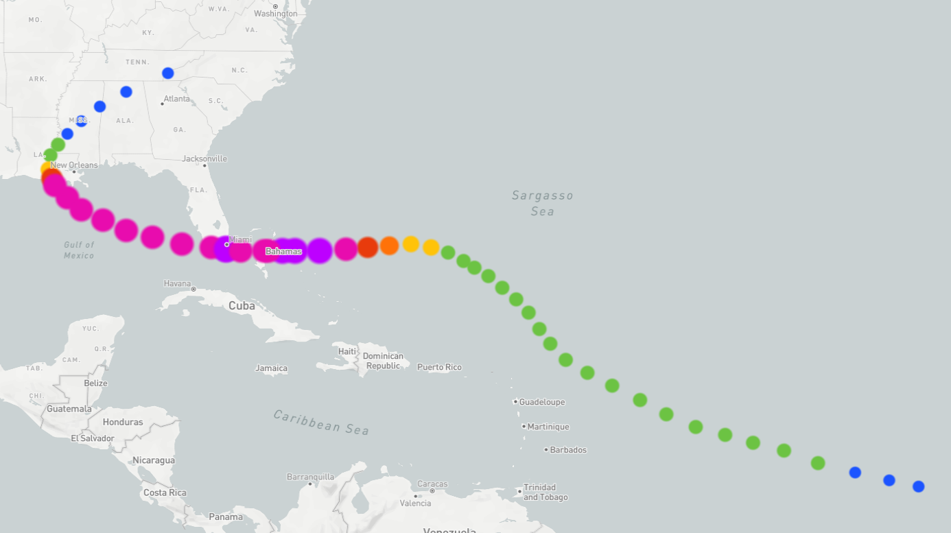
The 1992 Hurricane Andrew timeline spans from its humble origins as a tropical wave off the coast of Africa on August 14 to its final dissipation over the Appalachian Mountains on August 28. This two-week period saw Andrew evolve into a catastrophic Category 5 hurricane, forever changing emergency management, building codes, and the insurance industry in the United States.
The Genesis of a Giant: August 14–August 16, 1992
The atmospheric conditions of mid-August 1992 did not initially suggest the birth of a historic disaster. In fact, for the first week of its existence, Andrew was a struggling system that meteorologists at the National Hurricane Center (NHC) viewed with cautious skepticism rather than alarm.
August 14: The African Easterly Wave
The timeline begins on August 14, 1992, when a tropical wave emerged from the western coast of Africa. This is a common phenomenon during the Atlantic hurricane season, where pulses of energy move westward across the "Main Development Region." At this stage, the system was merely a disorganized cluster of thunderstorms moving into the eastern Atlantic.
August 15–16: Moving into the Open Atlantic
As the wave tracked westward, it faced significant environmental challenges. Strong upper-level wind shear and a massive high-pressure system to the north initially inhibited the system’s ability to organize. On August 15 and 16, the wave maintained a steady westward pace but showed little sign of the rapid intensification that would later define its legacy.
Development and Early Struggles: August 17–August 20, 1992
During this period, Andrew was officially named, but it nearly succumbed to the harsh conditions of the Atlantic environment.
August 17: Tropical Depression Three Becomes Andrew
By the morning of August 17, the system had developed enough closed circulation to be classified as Tropical Depression Three. Later that day, as wind speeds reached 40 mph, the NHC upgraded the system to Tropical Storm Andrew. Despite this milestone, the storm remained "lopsided" and poorly organized due to persistent southwesterly wind shear.
August 18–20: A Storm on the Brink of Dissipation
For three days, Andrew struggled to survive. The storm encountered a deep trough of low pressure that increased wind shear, nearly tearing the storm's internal structure apart. On August 19 and 20, some forecast models even suggested that Andrew might dissipate entirely before reaching the Caribbean. It was a small, compact storm, which made it highly sensitive to its immediate environment—a trait that would later allow it to intensify with terrifying speed once conditions improved.
The Rapid Intensification Phase: August 21–August 22, 1992
The timeline of Hurricane Andrew shifted dramatically on August 21. The environmental factors that had been suppressing the storm suddenly vanished, replaced by a massive high-pressure ridge over the U.S. East Coast that forced the storm westward into a pocket of warm water and low shear.
August 21: The Turn Toward the West
A powerful high-pressure system built to the north of Andrew, acting like a wall that blocked its path to the open North Atlantic and steered it directly toward the Bahamas and Florida. As the shear dropped, the storm began to "wrap" its convection around the center, forming a defined eye.
August 22: Reaching Hurricane Strength
On the morning of August 22, Andrew was upgraded to a Category 1 hurricane. What followed was a period of "explosive deepening." In just 24 hours, the central pressure dropped significantly, and wind speeds skyrocketed. By the evening of August 22, Andrew had reached Category 4 status. The storm’s forward speed also increased, meaning residents in its path had less time to prepare than they would for a typical, slower-moving hurricane.
Landfall in the Bahamas: August 23, 1992
Before striking the United States, Andrew brought its full fury to the islands of the Bahamas. This stage of the timeline is critical because it was here that Andrew first achieved Category 5 status—a fact that was only officially confirmed years later through post-storm reanalysis.
August 23: The First Strike
Andrew made landfall on Eleuthera Island in the Bahamas with sustained winds of 160 mph. The storm's compact size meant that while the destruction in the direct path of the eye was total, areas just a few dozen miles away experienced much lighter conditions. After crossing Eleuthera, the storm weakened slightly as it passed over the shallow waters of the Great Bahama Bank, but it quickly regained its strength as it moved into the deep, warm waters of the Florida Straits.
The South Florida Catastrophe: August 24, 1992
August 24 remains one of the darkest dates in Florida history. In the pre-dawn hours, Andrew slammed into the southern coast of the Florida peninsula, bringing a level of wind damage that had not been seen in the U.S. since the 1935 Labor Day Hurricane.
4:40 AM: Landfall at Elliott Key
Andrew made its first Florida landfall on Elliott Key, an island in Biscayne National Park, as a Category 5 hurricane. Sustained winds were estimated at 165 mph, with gusts exceeding 200 mph.
5:05 AM: The Destruction of Homestead and Florida City
The eye of the storm moved over the mainland near Fender Point and directly over the city of Homestead and the Homestead Air Force Base. Because Andrew was a "dry" hurricane compared to others (meaning it moved quickly and didn't drop as much rain), the damage was almost entirely wind-driven. Entire neighborhoods were leveled, and the iconic "turkey point" nuclear power plant chimneys were subjected to immense stress, though the reactors remained safe.
The NHC Radar Failure
In a moment that has become part of meteorological lore, the official NHC radar located on the roof of the University of Miami’s Gables One Tower was blown off the building during the height of the storm. Meteorologists, including then-Director Bob Sheets, were forced to rely on satellite data and land-based reports until the storm passed.
| Time (EDT) | Location | Status | Sustained Winds (mph) | Central Pressure (mbar) |
|---|---|---|---|---|
| Aug 23, 6:00 PM | Eleuthera, Bahamas | Category 5 | 160 | 922 |
| Aug 24, 4:40 AM | Elliott Key, FL | Category 5 | 165 | 922 |
| Aug 24, 5:05 AM | Homestead, FL | Category 5 | 165 | 923 |
| Aug 24, 8:00 AM | Gulf of Mexico | Category 4 | 135 | 937 |
| Aug 26, 3:30 AM | Point Chevreuil, LA | Category 3 | 115 | 956 |
The Gulf of Mexico Crossing: August 25, 1992
After spending only about four hours crossing the Florida peninsula, Andrew emerged into the Gulf of Mexico. While many inland hurricanes weaken significantly and stay weak, Andrew’s path over the warm Gulf waters allowed it to remain a major hurricane.
August 25: Regrouping for a Second Strike
Throughout August 25, Andrew tracked northwestward across the Gulf. Although it never regained Category 5 status, it remained a formidable Category 4 storm for much of the day. Oil rigs in the Gulf were evacuated as the storm moved toward the Louisiana coastline. The Mississippi River Delta and the low-lying parishes of southern Louisiana prepared for a massive storm surge.
Louisiana Landfall and Dissipation: August 26–August 28, 1992
The final chapter of Andrew’s life as a tropical system took place in the bayous of Louisiana and the forests of the American South.
August 26: Landfall in St. Mary Parish
At approximately 3:30 AM on August 26, Andrew made its final landfall near Point Chevreuil, Louisiana. It was a Category 3 hurricane at the time, with sustained winds of 115 mph. The storm caused significant damage to the state's fishing and agriculture industries, and the storm surge pushed far into the Atchafalaya Basin.
August 27–28: From Remnant to Dissipation
As it moved inland over Mississippi and into the Tennessee Valley, Andrew weakened rapidly. By August 27, it was a tropical depression. By August 28, the system had merged with a frontal boundary over the Appalachian Mountains. While it continued to produce heavy rain as it moved toward the Northeast, it was no longer a distinct tropical cyclone.
The Immediate Aftermath and "The Cavalry"
In the days following August 24, the situation in South Florida turned from a natural disaster into a humanitarian crisis. The sheer scale of the destruction caught local and state officials off guard.
The Breakdown of Relief
Communication lines were severed, and many roads were impassable due to downed power lines and debris. It took several days for the federal government to coordinate a massive response. This delay led to the famous exclamation by Kate Hale, Dade County’s emergency management director, who pleaded during a televised press conference: "Where the hell is the cavalry? For God's sake, where are they?"
The Deployment of the Military
Following the outcry, President George H.W. Bush ordered the deployment of over 20,000 soldiers and Marines to South Florida. They established "Tent Cities" to house the tens of thousands of newly homeless residents and provided essential services like food distribution and security to prevent looting.
Long-term Impacts and Changes to Building Codes
The 1992 Hurricane Andrew timeline does not truly end with the storm's dissipation; its effects are still being felt in 2026 through the evolution of building science and insurance law.
The Failure of the Building Codes
Post-storm investigations revealed that many of the homes destroyed in Homestead had not failed because the winds were too strong, but because the existing building codes were poorly enforced or insufficient. Stapled roofing felt, unreinforced masonry, and "missile" damage from flying debris were the primary culprits.
The Florida Building Code (2001)
In the years following Andrew, Florida overhauled its construction standards, leading to the creation of the Florida Building Code in 2001. These regulations, which are among the strictest in the world, require:
- Impact-resistant glass or hurricane shutters for all new windows.
- Enhanced roof-to-wall connections using hurricane straps rather than just nails.
- Stricter inspections during the construction process to ensure compliance.
The Insurance Market Revolution
Prior to 1992, many insurance companies viewed Florida as a profitable and relatively low-risk market. Andrew proved that a single "direct hit" on a major metropolitan area could cause tens of billions of dollars in losses.
Insolvencies and Market Flight
In the wake of the storm, at least 11 insurance companies went bankrupt, unable to pay out the volume of claims generated by Andrew. Many other major national carriers threatened to leave the state entirely. To prevent a total collapse of the real estate market (which requires insurance for mortgages), the Florida Legislature created the Florida Hurricane Catastrophe Fund and what is now known as Citizens Property Insurance Corporation—the state-run "insurer of last resort."
Frequently Asked Questions
Was Hurricane Andrew the strongest hurricane to hit the U.S.?
At the time of landfall in 1992, it was considered the third strongest. However, in 2026, it remains in the top five. In terms of central pressure at landfall (922 mbar), it is surpassed only by the 1935 Labor Day Hurricane, Hurricane Camille (1969), and Hurricane Michael (2018).
How long did it take for South Florida to recover from Andrew?
The physical recovery took nearly a decade. While many businesses reopened within a year or two, the population of Homestead and Florida City shifted permanently. Many residents moved north to Broward or Palm Beach Counties, a phenomenon known as "Andrew Migration," which permanently altered the demographics of the region.
Why was Andrew upgraded to a Category 5 ten years after it happened?
The National Hurricane Center conducted a "reanalysis" of historical storms using newer technology and a better understanding of the relationship between central pressure and wind speed at the surface. In 2002, they concluded that Andrew’s sustained winds were higher than originally estimated, warranting an upgrade from Category 4 to Category 5.
What happened to the NHC headquarters after the storm?
The destruction of the radar on the roof of their Coral Gables office was a wake-up call. The NHC eventually moved to a much more secure, "hurricane-proof" facility on the campus of Florida International University in West Miami-Dade, which was designed to withstand a Category 5 strike.
Did Hurricane Andrew cause any tornadoes?
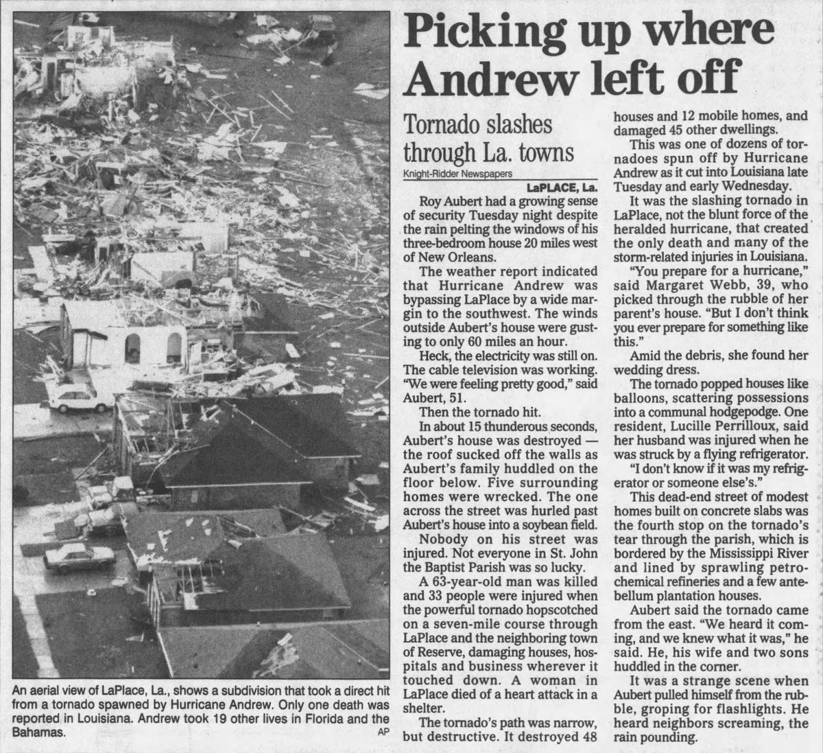
Yes, Andrew produced several tornadoes as it moved through Louisiana and the Southeastern U.S. While the primary damage in Florida was from "straight-line winds" and microbursts within the eyewall, the interaction with land in Louisiana triggered several tornado cells in the outer bands.
Future Preparedness and Final Recommendations
The timeline of Hurricane Andrew serves as a stark reminder of how quickly a "quiet" hurricane season can turn into a historic catastrophe. Andrew was the first named storm of an exceptionally late season, proving that quantity of storms does not always correlate with the level of danger.
For residents in hurricane-prone areas, the primary lesson of Andrew is the importance of structural integrity. While evacuation is necessary for storm surge, "hunkering down" requires a home built to modern standards. Ensure your roof-to-wall connections are inspected, and never rely on tape or inferior materials to protect windows. In 2026, the data from Andrew continues to inform the high-velocity hurricane zones (HVHZ) requirements that save lives every time a major storm approaches the coast.