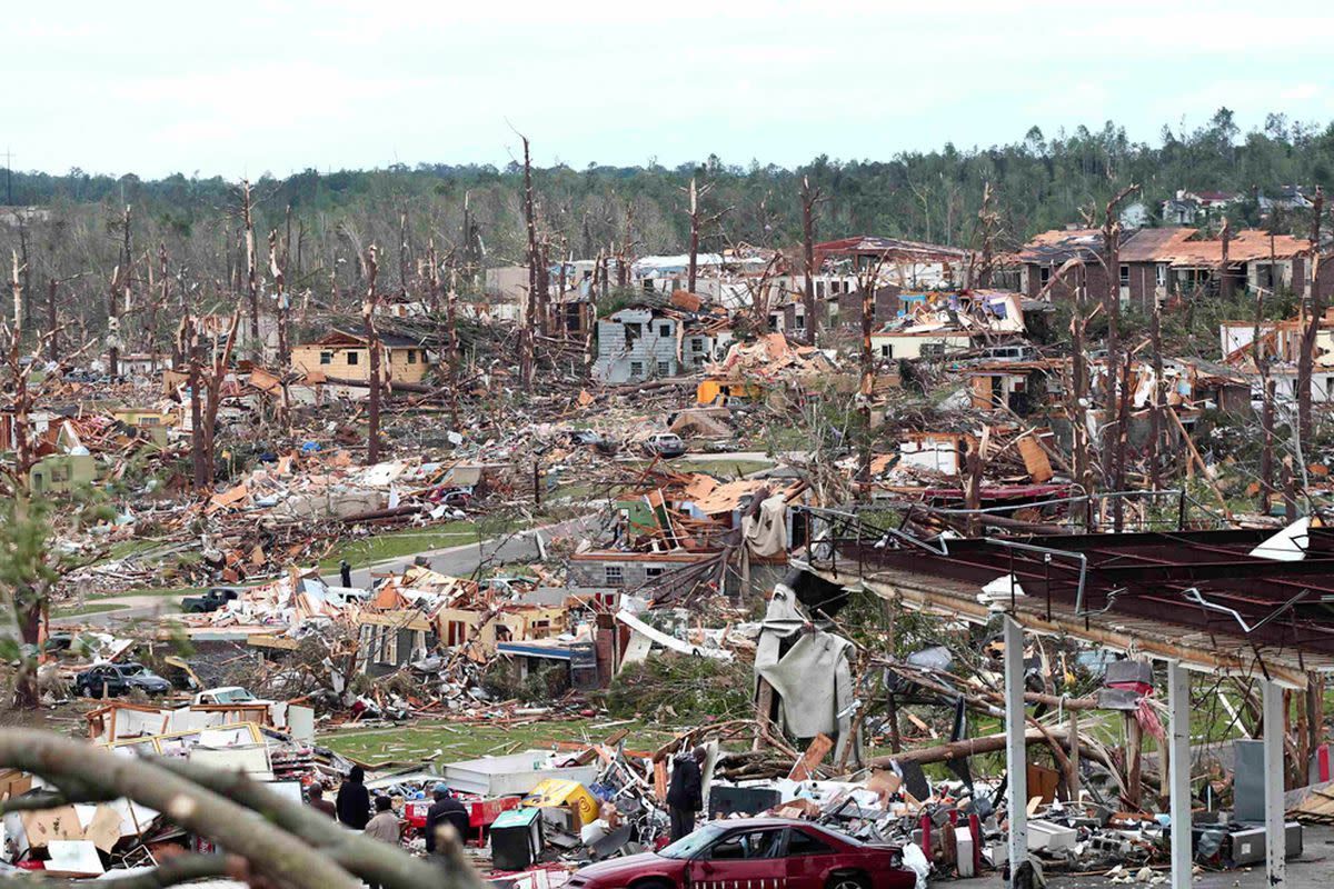
On April 27, 2011, a violent EF4 multiple-vortex tornado devastated Tuscaloosa and Birmingham, Alabama, as part of the historic 2011 Super Outbreak. With maximum winds of 190 mph and a path length of 80.7 miles, the storm caused 64 fatalities and more than 1,500 injuries. As of 2026, it remains a benchmark event for meteorological study, urban recovery, and the evolution of emergency alert systems in the United States.
The Meteorological Context of the 2011 Super Outbreak
To understand the 2011 Tuscaloosa tornado, one must first examine the unprecedented atmospheric conditions that defined the April 25–28 Super Outbreak. This period saw 360 confirmed tornadoes across 21 states, but April 27 was the deadliest day. A powerful cold front collided with moist, unstable air from the Gulf of Mexico, fueled by an exceptionally strong jet stream.
Meteorologists in 2011 noted a "triple point"—a junction of a dry line, a warm front, and a cold front—which provided the lifting mechanism necessary for supercell development. The wind shear was so intense that any storm that managed to form was almost guaranteed to rotate. This setup created a high-risk environment that the Storm Prediction Center (SPC) had warned about days in advance. By the afternoon of April 27, the "cap" (a layer of warm air aloft that prevents storm formation) broke, leading to the explosive development of discrete supercells across Mississippi and Alabama.
The specific storm that struck Tuscaloosa originated in Newton County, Mississippi. It was a classic "long-track" supercell, maintaining its structure and intensity for hours as it moved northeast. This storm was particularly dangerous because it was a multiple-vortex tornado, meaning smaller sub-vortices were rotating around the main center, significantly increasing the breadth and unpredictability of the damage.
The Path of Destruction: From Greene County to Birmingham
The tornado touched down in rural Greene County at approximately 4:43 PM CDT. Initially, it was a relatively small vortex, but it grew rapidly in size and strength as it approached the city limits of Tuscaloosa. By the time it crossed the Black Warrior River and entered the city, the tornado had expanded to a width of approximately 1.5 miles.
Impact on Tuscaloosa
Tuscaloosa bore the brunt of the storm's peak intensity. The tornado tore through the heart of the city, moving through neighborhoods such as Forest Lake and Alberta City. Major commercial corridors, including 15th Street and McFarland Boulevard, were decimated. Landmarks that had stood for decades were reduced to concrete slabs.
The University of Alabama, while spared a direct hit on its main historic quad, saw significant damage to student housing and surrounding infrastructure. The loss of life in Tuscaloosa was concentrated in high-density residential areas where many residents, including numerous university students, lived in structures that were not designed to withstand EF4 winds.
The Birmingham Corridor
After exiting Tuscaloosa, the tornado maintained its EF4 strength as it moved through the communities of Holt, Concord, and Pleasant Grove. It eventually entered the western suburbs of Birmingham. The path of the tornado was so wide and the debris cloud so massive that it was visible on live television from tower cameras miles away. The storm finally dissipated near downtown Birmingham, but not before leaving an 80-mile scar across the Alabama landscape.
Technical Classification: Why EF4 and Not EF5?
Following the disaster, National Weather Service (NWS) survey teams spent weeks analyzing the damage. The tornado was officially rated a high-end EF4 with peak winds estimated at 190 mph. This rating is often a point of technical discussion among meteorology students and enthusiasts in 2026.
Under the Enhanced Fujita (EF) Scale, a tornado is rated based on the damage it inflicts on specific "Damage Indicators" (DIs). While the Tuscaloosa tornado exhibited extreme violence—leveling well-built homes and tossing heavy vehicles—surveyors found that many of the destroyed buildings had structural weaknesses, such as a lack of anchor bolts or poor foundation connections.
To reach an EF5 rating (over 200 mph), a tornado must demonstrate the total destruction of a "well-built" structure that meets modern engineering codes. Because many of the impacted buildings in 2011 did not meet these specific technical criteria for EF5 evidence, the NWS maintained the EF4 rating. However, the sheer volume of debris and the ground-scouring observed in parts of Alberta City suggested a storm that was operating at the very limit of the EF4 classification.
The Human and Economic Toll
The 2011 Tuscaloosa tornado was a catastrophe of scale. In terms of casualties, it remains one of the deadliest single tornadoes in American history.
- Fatalities: 64 people lost their lives in this single event.
- Injuries: Over 1,500 individuals required medical treatment, overwhelming local hospitals like DCH Regional Medical Center.
- Displacement: Thousands of homes were destroyed, leaving a significant portion of the Tuscaloosa population homeless in the immediate aftermath.
The economic impact was equally staggering. Insured losses were estimated at over $2.4 billion (in 2011 dollars). When adjusted for the economic environment of 2026, the total cost of rebuilding and lost productivity exceeds $3.5 billion. The destruction of local businesses along the McFarland corridor led to a multi-year recovery period for the city’s tax base.
Evolution of Emergency Management and Technology
Fifteen years later, in 2026, the legacy of the Tuscaloosa tornado is most visible in how we prepare for disasters. This event served as a catalyst for several major shifts in emergency technology and public policy.
Radar Technology and Debris Balls
The 2011 event was one of the first times that the "Tornado Debris Ball" was widely recognized on radar in real-time. Using dual-polarization radar technology (which was then being rolled out across the NWS network), meteorologists could see not just the rotation, but the physical debris being lofted into the atmosphere. This allowed for "Tornado Emergencies" to be issued with high confidence, telling residents that a damaging tornado was confirmed on the ground, not just indicated by rotation.
The Rise of Wireless Emergency Alerts (WEA)
In 2011, many residents relied on outdoor sirens or NOAA Weather Radios. However, the Tuscaloosa tornado proved that sirens were often inaudible during high winds or rain. Since then, the federal government and cellular providers have perfected the Wireless Emergency Alert (WEA) system. Today, in 2026, these geofenced alerts are the primary way citizens receive life-saving information, a direct response to the communication failures observed during the 2011 Super Outbreak.
Urban Planning and "The Path Forward"
Tuscaloosa's recovery was guided by a strategic plan titled "The Path Forward." Instead of simply rebuilding what was lost, the city invested in "Safe Rooms" in new public buildings and implemented stricter building codes. Alberta City, once a scene of total desolation, was redesigned with improved infrastructure, parks, and a dedicated community center that doubles as a storm shelter.
Comparative Data: The Tuscaloosa Tornado vs. Historic Storms
The following table compares the 2011 Tuscaloosa-Birmingham tornado with other significant tornadoes in U.S. history to provide context for its scale and impact.
| Tornado Event | Date | EF/F Rating | Path Length (Miles) | Fatalities | Estimated Cost (Adjusted) |
|---|---|---|---|---|---|
| Tuscaloosa-Birmingham | April 27, 2011 | EF4 | 80.7 | 64 | ~$3.5 Billion |
| Joplin, Missouri | May 22, 2011 | EF5 | 22.1 | 158 | ~$4.2 Billion |
| Tri-State Tornado | March 18, 1925 | F5 | 219.0 | 695 | N/A (Historic) |
| Moore, Oklahoma | May 20, 2013 | EF5 | 17.0 | 24 | ~$2.8 Billion |
| Mayfield, Kentucky | Dec 10, 2021 | EF4 | 165.7 | 57 | ~$1.1 Billion |
FAQ: Understanding the 2011 Event
How long did the tornado stay on the ground?
The tornado was on the ground for approximately 90 minutes. It touched down in Greene County at 4:43 PM and eventually dissipated northeast of Birmingham around 6:14 PM. Its forward speed was roughly 50 to 60 mph, which is exceptionally fast and left residents with very little time to react once the storm entered their immediate vicinity.
Did the tornado hit the University of Alabama campus?
The tornado passed just south and east of the main University of Alabama campus. While the iconic Denny Chimes and the Quad were not damaged, many off-campus housing complexes where students resided were completely destroyed. Six students were among the fatalities in Tuscaloosa.
Why were there so many deaths despite the warnings?
The NWS issued warnings with significant lead times—often more than 20 minutes. However, the sheer violence of an EF4 tornado means that standard "interior rooms" in wood-frame houses are often insufficient for survival. The high death toll was attributed to the tornado’s path through densely populated areas and the lack of accessible underground shelters or reinforced safe rooms in older residential structures.
Is Tuscaloosa still at high risk for tornadoes?
Tuscaloosa is located in a region often referred to as "Dixie Alley." Unlike the traditional Tornado Alley in the Plains, Dixie Alley experiences tornadoes year-round, often at night, and in high-moisture environments that make storms difficult to see. While the 2011 event was a rare "generational" outbreak, the geographic risk remains constant.
How has the area changed by 2026?
By 2026, the physical scars on the landscape have largely healed. The "scar" visible on satellite imagery for years has been covered by new growth and development. However, the cultural memory of the storm remains a cornerstone of the community. Annual commemorations and the presence of community storm shelters serve as permanent reminders of the event.
Final Recommendations for Tornado Preparedness
Reflecting on the 2011 Tuscaloosa tornado highlights the necessity of a multi-tiered safety plan. In the modern era of 2026, relying on a single warning source is no longer acceptable.
- Redundant Warning Systems: Ensure you have at least three ways to receive alerts: a smartphone with WEA enabled, a battery-operated NOAA Weather Radio, and a local news app.
- Physical Sheltering: If you live in a high-risk area like Alabama, identify the nearest certified storm shelter. If your home does not have a basement, consider installing an in-ground or above-ground "Safe Room" that meets FEMA P-361 standards.
- Documentation and Insurance: Keep a digital inventory of your property. The 2011 recovery was significantly delayed for many because they lacked proper documentation for insurance claims.
- Community Awareness: Understand the difference between a "Watch" (conditions are favorable) and a "Warning" (a tornado is occurring or imminent). In the 2011 event, many people waited to see the storm before taking cover—a fatal mistake given the tornado's 60 mph forward speed and rain-wrapped nature.
The 2011 Tuscaloosa tornado remains a sobering reminder of nature's power. Its study continues to save lives today by informing better engineering, better meteorology, and a more resilient public.