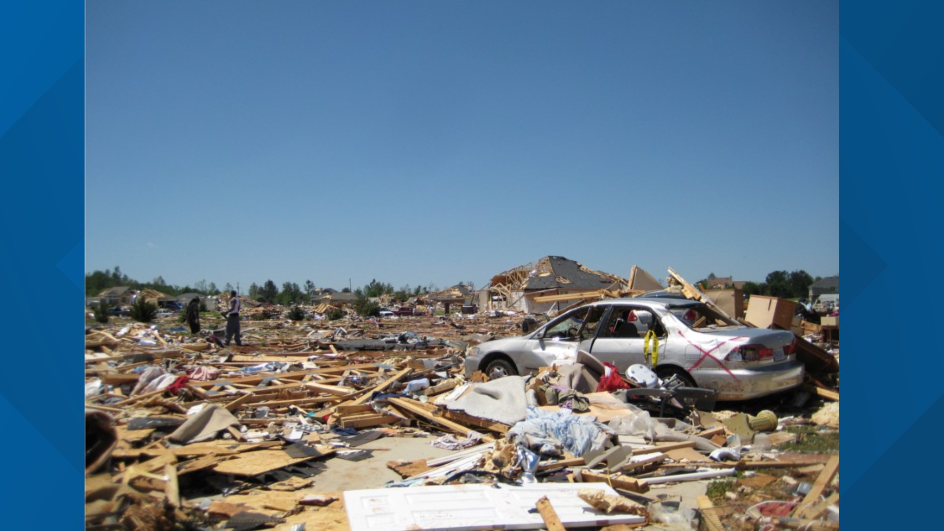
The 2011 Super Outbreak remains the most prolific and devastating tornado event in recorded history, occurring between April 25 and 28, 2011. It produced 360 confirmed tornadoes across 21 states and Canada, resulting in 324 direct fatalities. The peak of the event on April 27 saw four EF5 tornadoes and over $10 billion in damages.
As we look back from 2026, the 2011 Super Outbreak continues to serve as the benchmark for severe weather forecasting, emergency management, and community resilience. This event was not merely a cluster of storms but a generational meteorological anomaly that challenged the limits of modern technology and human endurance. Understanding why this event happened, how it unfolded, and what we have learned in the fifteen years since is essential for anyone living in storm-prone regions.
The Meteorological Setup: A "Loaded Gun" Scenario
To understand the 2011 Super Outbreak, one must first analyze the atmospheric conditions that coalesced in late April. Meteorologists often refer to this as a "loaded gun" sounding—a state where the atmosphere holds immense potential energy that only requires a small trigger to release a catastrophic amount of power.
Several critical factors converged over the Deep South and the Ohio Valley during this four-day period:
- Extreme Instability (CAPE): Convective Available Potential Energy (CAPE) levels were extraordinarily high. Warm, moist air from the Gulf of Mexico surged northward, meeting much cooler, drier air from the Rockies. This created a highly unstable environment where rising air could accelerate at incredible speeds.
- Strong Wind Shear: A powerful, south-moving jet stream provided the necessary vertical wind shear. Wind shear—the change in wind speed and direction with height—is the primary ingredient required to tilt a thunderstorm and cause it to rotate, forming a mesocyclone.
- The Deep Low-Pressure System: A vigorous upper-level trough moved out of the Western United States, deepening as it crossed the Plains. By April 27, this system created a surface low-pressure center that maximized the "spin" in the lower levels of the atmosphere.
- The "Cap" and the Trigger: Initially, a layer of warm air aloft (the cap) prevented storms from forming too early in the day. This allowed heat and moisture to build up at the surface. When the cold front and a dryline eventually "broke" the cap, the atmosphere exploded with discrete supercell thunderstorms.
The geographical focus of this outbreak was "Dixie Alley," a region encompassing parts of Alabama, Mississippi, Tennessee, and Georgia. Unlike the traditional Tornado Alley in the Great Plains, Dixie Alley presents unique challenges: hilly terrain, dense forests that obscure visibility, and a higher frequency of fast-moving, rain-wrapped tornadoes.
Chronology of the Outbreak: April 25–28, 2011
While April 27 is the date most associated with the tragedy, the Super Outbreak was a four-day progression of violence that moved from the Central U.S. toward the Atlantic Coast.
April 25: The Opening Salvo
The outbreak began in the mid-Mississippi Valley. Arkansas was hit particularly hard, with an EF2 tornado striking Vilonia, killing four people. This initial wave produced 42 tornadoes, signaling to meteorologists at the Storm Prediction Center (SPC) that the coming days would be increasingly dangerous.
April 26: The Transition
The system moved eastward, producing 55 tornadoes. While fewer fatalities were recorded on this day, the atmospheric "priming" continued. Significant damage occurred in parts of Texas and Louisiana, but the primary concern shifted toward the Tennessee and Ohio River Valleys, where the core of the storm system was expected to arrive the following morning.
April 27: The Catastrophic Peak
April 27, 2011, stands as one of the darkest days in American meteorological history. The day featured three distinct "waves" of severe weather:
- The Morning Wave: A Quasi-Linear Convective System (QLCS) or squall line moved through Alabama and Mississippi, causing widespread power outages and minor tornado damage. This wave actually complicated the forecast; many residents thought the "storm was over" by noon, not realizing the most dangerous supercells were still hours away.
- The Midday Wave: As the sun came out, the atmosphere "recharged." Discrete supercells began to fire in eastern Mississippi and western Alabama.
- The Afternoon/Evening Wave: This was the most violent phase. Multiple long-track, "wedge" tornadoes (tornadoes that are as wide as they are tall) tore through major population centers, including Tuscaloosa, Birmingham, and Smithville.
April 28: The Final Phase
As the system moved into the Mid-Atlantic and Northeast, it produced another 69 tornadoes. While the intensity began to wane, the storms still caused significant damage in Virginia and North Carolina before the system finally moved offshore into the Atlantic Ocean.
Profiles of the Most Violent Tornadoes
The 2011 Super Outbreak is defined by the sheer intensity of its individual storms. While hundreds of tornadoes occurred, four EF5s and several high-end EF4s accounted for the majority of the loss of life.
The Hackleburg-Phil Campbell Tornado (EF5)
This was the deadliest tornado of the outbreak. It traveled an incredible 132 miles across Northern Alabama, reaching a peak width of 1.25 miles. With wind speeds estimated at 210 mph, it completely leveled homes, debarked trees, and swept away entire structures in communities like Hackleburg and Phil Campbell. It resulted in 72 fatalities.
The Tuscaloosa-Birmingham Tornado (EF4)
Perhaps the most documented tornado in history at that time, this monster was captured live on multiple news cameras. It carved a path through the heart of Tuscaloosa—home to the University of Alabama—before moving into the suburbs of Birmingham. Despite being rated an EF4, the density of the population in its path led to 64 deaths and over 1,500 injuries.
The Smithville, Mississippi Tornado (EF5)
The Smithville tornado is often cited by meteorologists as one of the most "violent" in terms of ground-level damage. Though it had a relatively short path (15 miles), its wind speeds exceeded 205 mph. It was so powerful that it ripped up a municipal water system and granite tombstones from a cemetery. There were 16 fatalities in this small town.
The Rainsville, Alabama Tornado (EF5)
This storm exhibited extreme suction vortices. In Rainsville, the tornado was so intense that it scoured the ground to a depth of two feet and pulled an 800-pound safe from a house's foundation, throwing it hundreds of yards.
Comparative Analysis: 1974 vs. 2011
To understand the scale of 2011, it must be compared to the previous record-holder, the 1974 Super Outbreak.
| Feature | 1974 Super Outbreak | 2011 Super Outbreak |
|---|---|---|
| Dates | April 3–4, 1974 | April 25–28, 2011 |
| Confirmed Tornadoes | 148 | 360 |
| F5/EF5 Count | 7 | 4 |
| Fatalities (Direct) | 315 | 324 |
| Total Injuries | ~5,484 | ~3,100 |
| Economic Loss (Unadjusted) | ~$600 Million | ~$10.2 Billion |
| Average Lead Time | < 5 minutes | 24 minutes |
| States Affected | 13 | 21 |
The 2011 event produced more than double the number of tornadoes and resulted in slightly more fatalities, despite having significantly better warning technology. This discrepancy highlighted the "human factor"—the difficulty of communicating urgency and ensuring residents have access to adequate shelter.
Advancements in Meteorology Since 2011
In the fifteen years since the outbreak, the National Weather Service (NWS) and the National Oceanic and Atmospheric Administration (NOAA) have implemented radical changes to prevent a repeat of the 2011 death toll.
Dual-Polarization Radar
At the time of the 2011 outbreak, the NWS was just beginning to roll out Dual-Polarization (Dual-Pol) radar upgrades. Conventional radar could see "blobs" of precipitation, but Dual-Pol can distinguish between the shapes of objects. This allows meteorologists to confirm a "TDS" (Tornado Debris Ball)—a signature on radar that shows debris being lofted into the air, confirming a tornado is on the ground even at night or when rain-wrapped.
The Impact-Based Warning System
One of the major lessons from Tuscaloosa was that people often ignore "standard" tornado warnings. Since 2011, the NWS has moved to "Impact-Based Warnings." This includes tiered language such as "Tornado Emergency" for high-end, life-threatening situations, which triggers more aggressive alerts on mobile devices and television broadcasts.
Wireless Emergency Alerts (WEA)
In 2011, many people relied on outdoor sirens or NOAA weather radios. Today, the WEA system ensures that every modern smartphone in a warning polygon receives a loud, distinctive alert. This has significantly reduced the number of "surprised" victims, particularly during nocturnal events.
Enhanced Building Codes
States like Alabama have since updated building codes to encourage the construction of "safe rooms" and the use of "hurricane clips" (metal connectors that strengthen the bond between the roof and walls). Organizations like the Federal Emergency Management Agency (FEMA) have provided millions in grants for community storm shelters in the areas hardest hit in 2011.
Safety and Preparedness Lessons
The legacy of the 2011 Super Outbreak is one of survival and preparation. If you live in an area prone to severe weather, the following steps are considered the modern standard for safety:
- Identify Your "Safe Place": This should be the lowest level of a sturdy building, away from windows. If you do not have a basement, choose an interior closet or bathroom on the lowest floor.
- The "Helmet" Protocol: Many survivors of the 2011 outbreak survived by wearing bicycle or motorcycle helmets. Head trauma is the leading cause of death in tornadoes; protecting the head from flying debris is a critical, low-cost safety measure.
- Multiple Ways to Receive Alerts: Never rely on a single source. A combination of a NOAA Weather Radio, a smartphone app, and local news is the safest strategy. Sirens are designed for people outdoors and should not be your primary indoor warning.
- Early Action: In 2011, several of the EF5 tornadoes were moving at speeds of 60-70 mph. If you wait until you see the tornado, it is often too late. Move to your safe place as soon as a Tornado Warning is issued for your location.
Frequently Asked Questions
Why was the 2011 Super Outbreak so much worse than others?
The 2011 event was a "perfect storm" of atmospheric factors. It combined extreme instability with very high wind shear over a wide geographical area. Additionally, several of the tornadoes struck densely populated cities like Tuscaloosa and Birmingham, which significantly increased the potential for fatalities and property damage.
How many EF5 tornadoes occurred during the 2011 Super Outbreak?
There were four confirmed EF5 tornadoes, all occurring on April 27, 2011. These were the Hackleburg-Phil Campbell (AL), Smithville (MS), Rainsville (AL), and Philadelphia (MS) tornadoes. For context, an EF5 tornado is rare, occurring on average less than once per year in the United States.
What was the average lead time for warnings during the outbreak?
The National Weather Service provided an average lead time of 24 minutes for the tornadoes on April 27. This was significantly higher than the national average at the time. Despite this, the sheer violence of the storms meant that many standard "shelters"—such as interior rooms in wood-frame houses—were insufficient to survive direct hits from EF4 or EF5 winds.
Is the 2011 Super Outbreak linked to climate change?
While climate change is shifting the "timing" and "location" of tornado seasons (with an observed eastward shift toward the Southeast), it is difficult for scientists to attribute a single outbreak to global warming. Tornadoes are small-scale events, and the historical record is heavily influenced by changes in reporting technology. However, the 2011 event provided a massive dataset for researchers studying how atmospheric patterns might evolve in a warming world.
What is the difference between a Tornado Watch and a Tornado Warning?
A Tornado Watch means conditions are favorable for tornadoes to develop; you should remain alert and have a plan. A Tornado Warning means a tornado has been sighted or indicated by radar; you must take cover immediately. In 2011, "Tornado Emergencies" were also used to signify a confirmed, large tornado moving into a populated area.
Final Recommendations for Residents
The 2011 Super Outbreak proved that even with nearly half an hour of lead time, nature's most violent storms can still cause immense loss of life. The most practical next action for any resident in a high-risk area is to conduct a shelter audit.
Determine if your current "safe spot" could withstand a high-end tornado. If you live in a mobile home or a house without a basement, identify a nearby sturdy building or community shelter you can reach within 10 minutes. The 2011 event taught us that preparation must happen days in advance, not minutes. By the time the skies turn gray, your window for decision-making has already begun to close.