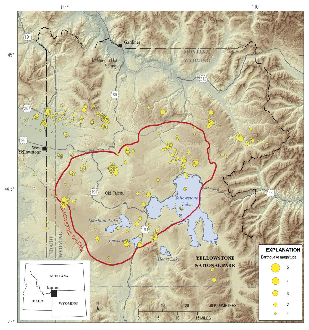
The Yellowstone volcanic system is a complex, active caldera complex characterized not by a single mountain peak, but by a massive underground reservoir of magma. Maps of the Yellowstone volcano size typically delineate the physical dimensions of the caldera—measuring approximately 30 by 45 miles—and the extent of the underlying magma chamber, which governs the geological behavior and potential hazard profiles of the region.
The Geography of the Yellowstone Caldera
When observers look at a map of the Yellowstone volcano, they are often struck by the lack of a traditional, cone-shaped volcanic peak. Unlike the stratovolcanoes of the Cascade Range, such as Mount St. Helens or Mount Rainier, Yellowstone is a caldera system. The "size" of the volcano is fundamentally defined by the surface footprint of the caldera, which was formed during three massive explosive eruptions over the last 2.1 million years.
The caldera floor covers roughly 1,500 square miles. To visualize this on a map, one must look at the central portion of Yellowstone National Park. The caldera itself is a large depression, partially filled by volcanic debris and younger lava flows. When viewing an official United States Geological Survey (USGS) map, the boundaries of the caldera are often highlighted to show the collapse area where the ground subsided after the most recent major eruption, known as the Lava Creek Tuff eruption, which occurred approximately 631,000 years ago.
Distinguishing Surface Features from Subsurface Reservoirs
A common point of confusion for those reviewing volcanic size maps is the difference between the surface caldera and the massive plumbing system beneath it. The magma reservoir is significantly larger in terms of volume, though it remains entirely underground.
Scientific mapping projects, utilizing seismic tomography—a technique that measures how earthquake waves travel through the Earth’s crust—have revealed the extent of the magma storage regions. Researchers have identified a large, upper crustal magma chamber and a deeper, much larger reservoir of molten rock. The upper chamber is approximately 50 miles long, 12 miles wide, and 3 to 7 miles deep.
When interpreting these maps, it is essential to understand that these chambers are not giant, empty caverns filled with liquid magma. Instead, they are largely composed of hot, solid rock, with pockets of melt (liquid magma) interspersed throughout the crystalline matrix. Mapping the "size" of the reservoir effectively involves mapping the volume of hot rock that remains thermally active.
Interpreting Geological Hazard Maps
Maps provided by the Yellowstone Volcano Observatory (YVO) are designed to communicate risk and scientific data to the public and emergency management agencies. These maps often overlay geological features with infrastructure, such as road networks, visitor centers, and hydrothermal basins.
Hazard maps, specifically, are distinct from structural size maps. Hazard maps identify:
- Lava Flow Zones: Areas where rhyolitic and basaltic lava have erupted in the past.
- Hydrothermal Explosion Zones: Areas where superheated water can cause localized, non-eruptive ground bursts.
- Ash Fall Models: Predictive maps that simulate where ash might travel based on wind patterns should an eruption occur.
It is a common misconception that a map of the "volcano size" indicates a binary "safe vs. unsafe" zone. In reality, the geological activity at Yellowstone is distributed. The YVO uses a monitoring network of GPS stations, seismometers, and satellite interferometry to track ground deformation—the rising or falling of the caldera floor—which is a primary indicator of subsurface activity.
Comparative Scale: Yellowstone and Other Systems
To better grasp the scale of the Yellowstone volcanic system, it is helpful to compare its dimensions against other well-known geological features. The 30-by-45-mile caldera is so large that it is often difficult to comprehend without a topographic overlay.
| Feature | Approximate Dimensions | Type |
|---|---|---|
| Yellowstone Caldera | 30 x 45 miles | Resurgent Caldera |
| Mount St. Helens | 6 x 8 miles (base area) | Stratovolcano |
| Long Valley Caldera | 10 x 20 miles | Caldera |
| Valles Caldera | 13.5 miles diameter | Caldera |
The table above illustrates the sheer magnitude of the Yellowstone system compared to standard volcanic cones. Because Yellowstone is a "supervolcano" system, its footprint is orders of magnitude larger, which necessitates the use of large-scale regional maps rather than local topographic maps to appreciate its full scope.
The Role of Monitoring Networks
The size of the volcano remains constant on a human timescale, but the internal state is dynamic. The YVO, a partnership between the USGS, the University of Utah, and the National Park Service, maintains an extensive monitoring network.
When you look at a live map provided by the YVO, you are observing real-time data points. The dots on these maps represent:
- Seismic Stations: Monitoring for earthquake swarms, which are common at Yellowstone and usually represent the movement of fluids rather than magma rising to the surface.
- GPS Arrays: Detecting millimeter-scale shifts in the Earth's surface that indicate crustal inflation or deflation.
- Thermal Sensors: Tracking heat output in areas like the Norris Geyser Basin or Old Faithful.
These tools do not "map the size" of the volcano in a static sense; they map the "behavior" of the volcano. The size is a given, but the activity level is the metric of interest for geologists and park management.
Common Misconceptions Regarding Maps
A frequently encountered error when viewing maps of the Yellowstone volcano is the belief that the "Yellowstone Supervolcano" is a singular, localized point of danger. Many laypeople look at a map and assume the red shading indicates a "bomb" ready to go off.
In reality, the entire area is a complex, evolved landscape of rhyolite plateaus and geothermal features. The maps that show "size" are capturing millions of years of crustal cooling and shifting. Furthermore, media depictions often exaggerate the maps by coloring the entire state of Wyoming or the park boundary as a magma zone. Accurate maps focus on the volcanic field, which is specifically centered on the caldera itself and the associated basaltic plains to the west.
Practical Steps for Tourists and Researchers
If you are planning to visit the region or are interested in the geology, your approach to map-reading should differ based on your goal:
- For Recreational Visitors: Focus on maps produced by the National Park Service. These highlight safe zones, boardwalks, and active hydrothermal areas. Respecting these boundaries is the most effective way to stay safe from the day-to-day geothermal hazards of the park.
- For Academic or Scientific Interest: Utilize the USGS Yellowstone Volcano Observatory (YVO) website. Their portals offer interactive maps that allow users to toggle between historical eruption layers, seismic sensor locations, and GPS deformation trends.
- For Emergency Awareness: Consult the official YVO hazardous event protocols. They provide clear, text-based guides that explain what the different alert levels mean, moving beyond simple map visualization into actionable safety data.
Frequently Asked Questions
Is the magma chamber beneath Yellowstone one giant pool of liquid? No. It is a "mush" zone. Geologists describe it as a sponge where the pores are filled with melt, rather than a single underground lake of liquid magma. The percentage of melt is relatively low, which is why the system remains stable and inactive.
Does a larger caldera size mean a larger potential eruption? Not necessarily. The size of the caldera is a record of past events. While it demonstrates the capacity of the system to produce large-volume eruptions, it does not dictate the size of a future event. Future eruptions, should they occur, could be small lava flows or explosive events of varying magnitudes.
Why do some maps show the volcano extending into Idaho? That is the "Yellowstone Hotspot" track. As the North American tectonic plate moves southwest over the stationary Yellowstone mantle plume, it leaves a trail of calderas across the Snake River Plain. The active caldera is the youngest in this series, located in Wyoming.
How often are the size maps updated? The physical dimensions of the caldera do not change significantly on a human timescale. However, maps reflecting volcanic activity, such as seismicity or ground deformation, are updated in near real-time through automated data feeds from the YVO sensors.
Are there parts of the park that are safer than others? Yellowstone is an active geological environment. While the risk of a catastrophic super-eruption is statistically extremely low, the risk of localized hydrothermal activity is always present. Staying on marked trails and boardwalks is the universal recommendation for safety throughout the entire park area.
Final Recommendation
To gain an accurate understanding of the Yellowstone volcanic system, do not rely solely on static images found in popular media. Instead, utilize the interactive, verified portals provided by the United States Geological Survey. Start by examining the "Yellowstone Volcano Observatory" website, where you can view historical data layers alongside real-time monitoring. For practical field guidance, rely on the official National Park Service maps, which are curated to prioritize visitor safety and ensure that you remain at a secure distance from active geothermal features. If you are conducting research, cross-reference these maps with peer-reviewed geological surveys to ensure you are interpreting the subsurface features with the correct technical context.