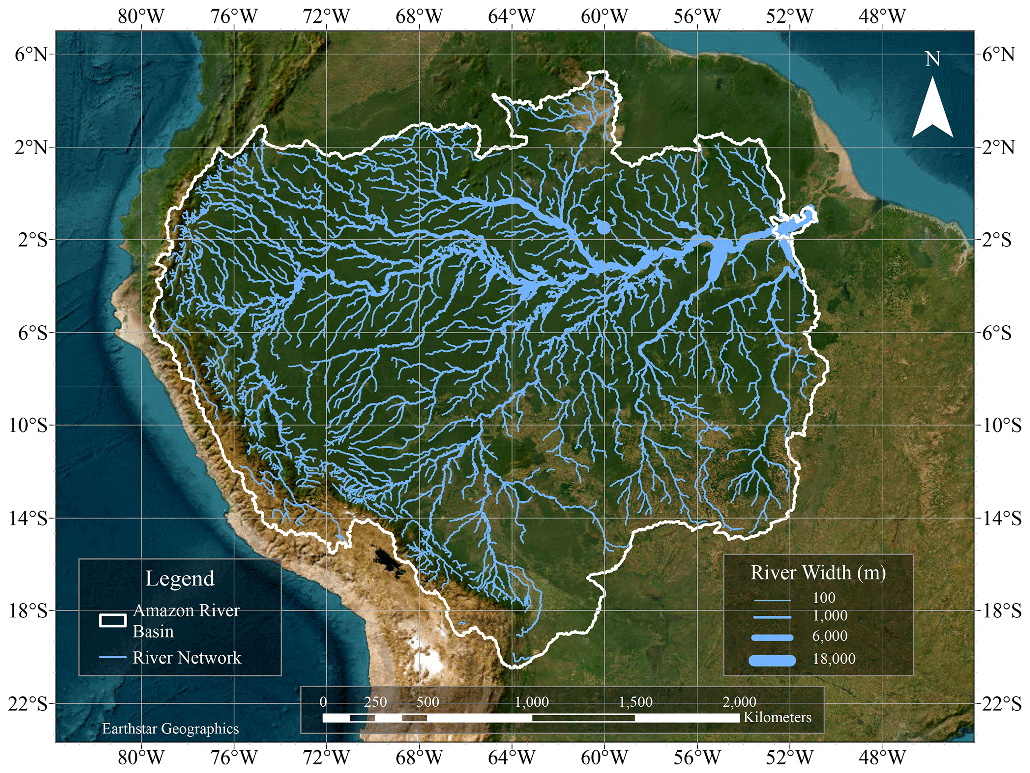
The Amazon River is the largest river in the world by water volume, containing more water than the next seven largest independent rivers combined. Spanning South America, it drains a massive basin of approximately 7 million square kilometers, supports thousands of unique species of aquatic and terrestrial wildlife, and sustains diverse indigenous communities across multiple nations.
Introduction to the Amazon River Basin
When examining the geography of our planet, few natural features command as much awe and scientific curiosity as the Amazon River. Flowing through South America—primarily across Brazil, Peru, and Colombia, while also drawing tributaries from Bolivia, Ecuador, and Venezuela—this colossal hydrological system defines an entire continent's ecosystem.
For decades, scientists, explorers, and geographers have debated the exact metrics of the Amazon, particularly its precise length and discharge rates. However, modern satellite telemetry, hydrological gauging stations, and field expeditions have solidified its status as a peerless natural wonder. To truly understand this waterway, one must look beyond simple length measurements and examine its discharge volume, ecological diversity, geological history, seasonal dynamics, and human footprint.
Fact 1: Unmatched Water Volume and Discharge Rates
The single most defining characteristic of the Amazon River is its sheer volume of water. While the Nile River in Africa is traditionally recognized as the longest river on Earth, the Amazon reigns supreme as the undisputed champion of discharge volume.
The Scale of Hydrological Output
The Amazon accounts for roughly twenty percent of the world’s total river flow into the oceans. During peak wet seasons, the mouth of the river discharges an astonishing volume of water into the Atlantic Ocean—roughly 209,000 cubic meters (about 7.38 million cubic feet) per second.
To visualize this immense output:
- The discharge is enough to fill Lake Ontario in less than four days.
- The freshwater plume alters the salinity and color of the Atlantic Ocean for over 100 miles away from the South American coastline.
- The river's mouth is so wide—reaching up to 240 miles (386 kilometers) across if you include the Para River and Marajó Bay—that early European explorers mistakenly referred to it as the Mar Dulce (Sweet Sea).
Why the Amazon Produces So Much Water
The colossal volume of the Amazon is driven by its vast drainage basin, which covers roughly 40 percent of the South American continent. The region experiences heavy tropical rainfall throughout the year, driven by the Intertropical Convergence Zone and moisture-laden winds blowing westward from the Atlantic Ocean. When these moisture-laden clouds hit the towering barrier of the Andes Mountains, they release torrential downpours that feed thousands of tributaries, which converge into the main stem of the Amazon.
Fact 2: A Massive Network of Over 1,100 Tributaries
The Amazon is not a single, isolated channel flowing from the mountains to the sea. Instead, it is the master collector of a sprawling vascular system composed of more than 1,100 major tributaries. Several of these feeder rivers are themselves larger than any river found in Europe or North America.
Major Tributaries of the System
Out of the thousands of contributing streams, roughly seventeen are major rivers in their own right. Notable tributaries include:
- The Madeira River: The largest tributary, contributing a massive volume of sediment and water from Bolivia and western Brazil.
- The Negro River (Rio Negro): Known for its striking dark, tea-colored water stained by decaying organic matter from the flooded forests.
- The Tapajós and Xingu Rivers: Clear-water rivers that drain the ancient crystalline rocks of the Brazilian Shield to the south.
- The Marañón and Ucayali Rivers: The primary headwater streams in Peru that merge to form the main stem of the Amazon River proper.
The Phenomenon of the Meeting of the Waters
One of the most famous visual spectacles within this tributary network occurs just downstream of Manaus, Brazil, where the dark, acidic waters of the Rio Negro meet the sandy, beige waters of the Amazon (known locally as the Solimões River). Because of differences in water temperature, speed, and water density, the two rivers flow side by side without mixing for approximately 45 miles (72 kilometers), creating a distinct dual-colored ribbon across the landscape.
Fact 3: Unrivaled Biodiversity and Aquatic Life
The Amazon River and its surrounding flooded forests (varzea and igapó) harbor the highest concentration of freshwater biodiversity on the planet. The aquatic ecosystem acts as an evolutionary laboratory, supporting thousands of species that have adapted specifically to the shifting water levels and complex chemistry of the basin.
Fish Diversity and Endemic Species
Ichthyologists have cataloged over 3,000 species of fish within the Amazon basin, with new species being discovered regularly. This accounts for roughly one-third of the world's freshwater fish species. Key aquatic inhabitants include:
- Piranhas: Omnivorous, schooling fish famous for their sharp teeth and powerful jaws, though most species scavenge rather than hunt large live prey.
- Electric Eels (Electrophorus species): Capable of generating powerful electrical discharges of up to 860 volts to navigate, communicate, and stun prey.
- Arapaima (Arapaima gigas): One of the largest freshwater fish in the world, capable of growing up to 10 feet (3 meters) in length and breathing atmospheric air using a modified swim bladder.
- Bull Sharks: Remarkably, these marine sharks have adapted to travel thousands of miles upstream into the freshwater reaches of the Amazon.
Iconic Mammals of the River
The Amazon is also home to specialized mammalian megafauna that rely entirely on the river system for survival. The Amazon river dolphin (Inia geoffrensis), also known as the pink river dolphin or boto, is the largest species of river dolphin in the world. Adapted to navigate flooded forests during the wet season, these intelligent cetaceans possess unfused cervical vertebrae that allow them to turn their heads 90 degrees to maneuver around tree trunks. Additionally, the giant otter (Pteronura brasiliensis)—the world's largest otter species—hunts fish cooperatively in family groups along the riverbanks.
Fact 4: Extreme Seasonal Fluctuations and the Flood Pulse
Unlike many temperate rivers that maintain relatively stable banks throughout the year, the Amazon experiences dramatic seasonal changes in water level. These fluctuations dictate the ecological rhythms of the entire basin and shape the lifestyles of local human settlements.
The Wet and Dry Seasons
The Amazon basin experiences distinct wet and dry seasons, though timing varies depending on whether a location sits north or south of the equator. During the peak rainy season, torrential downpours cause water levels to rise rapidly.
| Metric / Feature | Dry Season (Low Water) | Wet Season (High Water) |
|---|---|---|
| Water Level Rise | Baseline reference level | Rises 30 to 50 feet (9–15 meters) |
| Forest Inundation | Riverbanks exposed; sandbars form | Millions of acres of forest flooded |
| Aquatic Access | Restricted to main channels | Fish swim into forests to eat fruit |
| Human Transportation | Navigation can face low-water rocks | Boats navigate directly over trees |
The Ecological Importance of the Flood Pulse
This annual flooding, known as the "flood pulse," is essential for the health of the ecosystem. When the river overflows its banks, it deposits nutrient-rich sediments onto the floodplain soils. Furthermore, it allows fish to swim directly into the flooded forests (igapó) to feed on fallen fruits, seeds, and insects. Once the waters recede, these fish retreat to the main river channels, dispersing seeds across vast distances and driving the forest's reproductive cycle.
Fact 5: Geologic History and the Flow Reversal Mystery
The modern Amazon River is a relatively young geological feature, and its current configuration is the result of massive tectonic shifts that completely transformed the South American continent over millions of years.
From Westward Flow to Eastward Discharge
During the Cretaceous period, millions of years ago, the Amazon basin drained westward into the Pacific Ocean rather than eastward into the Atlantic. The rise of the Andes Mountains, caused by the collision of the Nazca and South American tectonic plates, eventually blocked this westward drainage.
As the mountains continued to uplift, a massive inland freshwater sea formed across the basin. Over time, erosion breached the eastern barrier, and the river carved a new path toward the Atlantic Ocean, establishing the eastward-flowing mega-river we see today. This geological shift explains why marine fossils can still be found deep within the interior of the Amazon basin.
Scientific Debates on River Length
While the Amazon is universally recognized as the largest river by volume, its exact length has been a subject of intense scientific debate. Traditional measurements placed the Nile at approximately 6,650 kilometers (4,132 miles) and the Amazon at 6,400 kilometers (3,977 miles). However, modern satellite studies led by Brazilian researchers have proposed alternative source points in the Peruvian Andes—specifically snowmelt-fed streams on Mount Mismi—which could push the Amazon's total length past 6,992 kilometers (4,345 miles), potentially making it both the largest and longest river on Earth.
Frequently Asked Questions
Is the Amazon River the longest river in the world?
While the Nile River is traditionally credited as the longest river in the world at roughly 6,650 kilometers, ongoing satellite studies and geographic surveys suggest the Amazon may be longer, depending on which headwater source is measured. The Amazon's true undisputed title, however, is the largest river in the world by water volume.
How deep is the Amazon River?
The depth of the Amazon River varies significantly depending on the location and the season. In its lower reaches, the river is typically between 65 and 150 feet (20 to 45 meters) deep. However, in certain narrow, bedrock-constrained sections near Óbidos, Brazil, the river plunges to depths exceeding 300 feet (90 meters), allowing deep-draft ocean-going cargo ships to travel hundreds of miles inland.
Are there sharks in the Amazon River?
Yes. Bull sharks (Carcharhinus leucas) are well-documented in the Amazon River. These euryhaline animals can tolerate freshwater environments and have been recorded swimming more than 2,000 miles (3,200 kilometers) upstream into the interior of Peru, utilizing specialized kidney functions to regulate salt balance.
Can you cross the Amazon River using bridges?
There are very few bridges crossing the main stem of the Amazon River. The primary crossing is the Rio Negro Bridge near Manaus, Brazil, which spans a major tributary, but crossing the main Amazon channel itself is typically accomplished using ferries, boats, or air travel due to the extreme shifting of banks, wide floodplains, and high construction costs.
What countries does the Amazon River flow through?
The main stem of the Amazon flows primarily through Brazil and Peru, while its vast basin incorporates major tributaries and watersheds extending into Colombia, Bolivia, Ecuador, and Venezuela.
Practical Next Actions and Recommendations
For researchers, travelers, and geography enthusiasts looking to deepen their understanding of the Amazon River, direct engagement with peer-reviewed hydrological studies and conservation organizations offers the most accurate data. When studying the basin, prioritize sources from institutions like the National Institute for Amazonian Research (INPA) in Brazil or scientific publications focusing on tropical ecology and climatology. If planning travel or field expeditions within the region, consult official government health advisories, secure appropriate vaccinations for tropical diseases, and utilize licensed, eco-certified tour operators committed to preserving indigenous territories and local wildlife habitats.