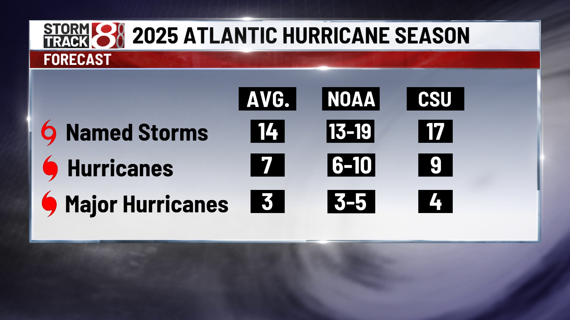
The 2025 Atlantic hurricane season generated significant advance attention from major meteorological organizations, who evaluated oceanic heat content, wind shear patterns, and prevailing atmospheric drivers to produce early outlooks for the Caribbean basin. Understanding these five forecasts provides critical context for evaluating how scientific models project tropical cyclone frequency, intensity, and potential regional impacts.
Introduction to the 2025 Caribbean Hurricane Season Outlooks
Long-range forecasting for tropical cyclone activity requires synthesizing vast amounts of oceanographic and atmospheric data. As the scientific community prepared for the 2025 Atlantic hurricane season, leading research centers, university teams, and governmental agencies released their initial seasonal predictions. These forecasts are designed to estimate overall activity levels—such as the total number of named storms, hurricanes, and major hurricanes—rather than predicting exact landfall locations months in advance.
For the Caribbean basin, which sits directly in the path of many developing tropical systems, these early projections serve as an essential baseline for disaster preparedness, insurance risk assessment, and infrastructure reinforcement. While individual outlooks varied in their specific numerical counts, a common thread united them: heightened sea surface temperatures across the tropical Atlantic and Caribbean Sea created conditions capable of supporting sustained tropical development. Evaluating these five primary forecasts reveals both the consensus and the methodological variations among the world's top meteorological authorities.
1. Colorado State University (CSU) Tropical Meteorology Project Forecast
The Tropical Meteorology Project team at Colorado State University, historically led by pioneering meteorologists and widely recognized for issuing some of the earliest seasonal hurricane outlooks, released closely watched projections for the 2025 season. CSU's methodology heavily emphasizes statistical modeling combined with recent analog years—past seasons that exhibited similar global atmospheric and oceanic patterns to those observed leading up to 2025.
Core Projections and Methodology
The CSU outlook typically evaluates parameters such as El Niño-Southern Oscillation (ENSO) phases, tropical Atlantic sea surface temperatures, and West African monsoon strength. For 2025, the team factored in the lingering or transitioning state of ENSO, leaning away from a strong El Niño—which typically suppresses Atlantic hurricane activity by increasing vertical wind shear—toward neutral or La Niña conditions. La Niña phases reduce wind shear across the Caribbean and tropical Atlantic, allowing storms to form and intensify more easily.
Implications for the Caribbean
CSU's probabilistic models highlighted an elevated risk for the Caribbean basin. Because warm ocean waters extend deep into the Caribbean Sea, storms entering the region from the central Atlantic often encounter high oceanic heat content, which acts as fuel for rapid intensification. The CSU forecast underscored the need for coastal communities across the Lesser Antilles, Greater Antilles, and the Central American coastline to maintain heightened vigilance throughout the peak months of August, September, and October.
2. National Oceanic and Atmospheric Administration (NOAA) Seasonal Outlook
As the official federal agency responsible for operational weather monitoring in the United States and surrounding territories, the National Oceanic and Atmospheric Administration (NOAA) issued its comprehensive outlook for the 2025 Atlantic hurricane season through the Climate Prediction Center. NOAA's predictions carry substantial weight because they incorporate state-of-the-art dynamical computer models alongside human expert analysis.
Dynamical Modeling and Guidance
NOAA's outlook relies heavily on multi-model ensembles, including the Climate Forecast System (CFS) and international partner models run by centers such as the European Centre for Medium-Range Weather Forecasts (ECMWF). These dynamical models simulate physical fluid dynamics in the atmosphere and oceans, providing a holistic view of global circulation patterns. For 2025, NOAA's initial outlook pointed toward an above-normal season, citing persistent warmth in the Main Development Region (MDR)—the stretch of the Atlantic Ocean extending from the west coast of Africa to the Caribbean Sea.
Regional Risk Assessment for Island Nations
NOAA's guidance emphasized that an above-normal season statistically increases the probability of direct impacts across the Caribbean. The agency stressed that tropical cyclones forming early in the season often originate in the Caribbean or the Gulf of Mexico, while mid-to-late season storms frequently develop off African wave trains and track directly westward across the Atlantic into the island chains. NOAA urged emergency managers in territories such as Puerto Rico, the U.S. Virgin Islands, and independent Caribbean nations to review contingency plans well before the official start of the season on June 1.
3. AccuWeather Long-Range Forecasting Team Outlook
Private sector meteorological firms also contribute significantly to the seasonal forecasting landscape. AccuWeather's long-range forecasting team, spearheaded by veteran meteorologists, provided an independent evaluation of the 2025 Atlantic hurricane season, often focusing on economic impacts and specific threat areas.
Focus on Rapid Intensification and Coastal Threats
AccuWeather's 2025 forecast distinguished itself by placing strong emphasis on the potential for rapid intensification events. Rapid intensification—defined as an increase in maximum sustained winds of at least 30 knots (34 mph) in a 24-hour period—poses a severe hazard to Caribbean islands and coastal shipping lanes, as it leaves minimal time for evacuation or preparation. The firm's forecasters pointed to exceptionally high ocean heat content not just at the surface, but dozens of meters deep into the water column, preventing upwelling from cooling the ocean as a storm passes overhead.
Economic and Logistical Considerations
Beyond meteorological statistics, AccuWeather's outlook analyzed the potential economic exposure for tourism, agriculture, and maritime commerce in the Caribbean. A hyper-active or even moderately active season with storms tracking through vital sea lanes can disrupt cruise itineraries, damage resort infrastructure, and halt agricultural exports. Their 2025 report served as a vital risk-management tool for businesses operating throughout the region.
4. The United Kingdom Met Office (UK Met Office) Atlantic Tropical Storm Forecast
The Met Office, the United Kingdom's national weather service, produces an influential annual outlook for the Atlantic hurricane season. Given the historical and economic ties between the UK and numerous Caribbean islands, as well as global shipping interests, the Met Office's projections provide a valuable European perspective on North Atlantic tropical activity.
Global Atmospheric Teleconnections
The Met Office forecast for 2025 integrated complex global teleconnections—links between weather anomalies occurring over different, widely separated regions of the globe. Their numerical weather prediction models analyzed sea surface temperature anomalies across the globe, including the Pacific, Indian, and Atlantic oceans, to assess the net driver strength for Atlantic basin activity.
Alignment with Global Consensus
The Met Office outlook generally aligned with the broader scientific consensus that 2025 would see an active season above the 1991–2020 climatological normal. Their models highlighted the role of the North Atlantic Oscillation (NAO) and regional pressure gradients in steering storms. For the Caribbean, the Met Office's mapping indicated that steering currents would likely favor westward-moving systems, keeping the region directly in the crosshairs during the climatological peak in September.
5. Tropical Storm Risk (TSR) Consortium Forecast
Operating out of University College London (UCL), the Tropical Storm Risk (TSR) consortium brings together experts in physics, risk modeling, and meteorology to issue quantitative forecasts for worldwide tropical cyclone activity, with a particular focus on the North Atlantic.
Quantitative Risk Modeling
TSR's forecasting methodology relies on advanced statistical models that evaluate two primary predictive factors: the projected August-September trade wind speed over the tropical Atlantic and Caribbean Sea, and the projected August-September sea surface temperature in the Main Development Region. Strong trade winds typically increase vertical wind shear and churn cooler deep water to the surface, suppressing storms, whereas weaker trade winds and warm waters favor development.
Probabilistic Landfall Indices
In their 2025 guidance, TSR provided not only total storm counts but also specific probabilistic indices for U.S. and Caribbean landfalls. By analyzing historical steering flow patterns and current climatological anomalies, TSR estimated the likelihood that Caribbean landfalls would exceed historical averages. This granular statistical approach allowed insurers and reinsurers to price risk more accurately across different sub-regions of the Caribbean basin.
| Forecasting Organization | Primary Methodological Focus | Projected Activity Level Relative to Normal | Key Risk Factor Highlighted for the Caribbean |
|---|---|---|---|
| Colorado State University (CSU) | Statistical analog years and ENSO phase analysis | Above-normal | High oceanic heat content fueling storm intensity |
| National Oceanic and Atmospheric Administration (NOAA) | Multi-model dynamical ensembles and MDR sea surface temperatures | Above-normal | Increased probability of direct island impacts |
| AccuWeather | Private sector risk modeling and rapid intensification tracking | Active to hyper-active | Accelerated intensification rates leaving less prep time |
| UK Met Office | Global numerical weather prediction and teleconnections | Above-normal | Westward steering currents favoring regional transit |
| Tropical Storm Risk (TSR) | Trade wind speed and regional SST statistical modeling | Above-normal | Quantitative landfall probability indices |
Key Meteorological Drivers Influencing the 2025 Season
To fully understand why these five forecasts converged on an active outlook for 2025, it is necessary to examine the underlying physical mechanisms driving tropical cyclogenesis in the Atlantic basin and Caribbean Sea.
Sea Surface Temperatures and Ocean Heat Content
The most critical ingredient for tropical cyclone formation and intensification is warm water. Throughout the lead-up to the 2025 season, sea surface temperatures across the tropical Atlantic Main Development Region and the Caribbean Sea remained significantly above historical averages. High ocean heat content provides the thermal energy necessary to power deep convection, create towering thunderstorm rainbands, and sustain intense hurricane-force winds.
Vertical Wind Shear and ENSO Conditions
Vertical wind shear—the change in wind speed and direction with height in the atmosphere—acts as a natural enemy to tropical cyclones by tilting the storm vortex and dispersing its warm core. The transition away from El Niño conditions toward neutral or La Niña phases during 2025 meant that upper-level westerly winds over the Caribbean were projected to remain relatively weak, removing a major atmospheric barrier that otherwise inhibits storm organization.
African Easterly Waves
The African Easterly Jet serves as the breeding ground for many of the most powerful hurricanes that affect the Caribbean. Vigorous African easterly waves moving off the coast of West Africa into the Atlantic find themselves embedded in an environment characterized by moist air masses and minimal dry air intrusion (Saharan Air Layer), enabling smooth transition from disorganized thunderstorm clusters into tropical depressions and named storms.
Practical Preparedness and Next Actions for Caribbean Communities
Seasonal forecasts provide vital early warnings, enabling governments, businesses, and individuals to transition from passive awareness to active disaster preparation before the hurricane season peaks.
- Review and Update Emergency Plans: Households and commercial entities should revisit evacuation routes, family communication strategies, and emergency supply inventories, ensuring at least two weeks of non-perishable food, water, and medical supplies.
- Infrastructure Hardening: Property owners in hurricane-prone zones should inspect roof tie-downs, install impact-resistant shutters or high-grade plywood protection, and clear surrounding vegetation that could become wind-borne debris.
- Insurance Policy Verification: Homeowners and business operators must examine property and flood insurance policies well in advance of storm threats, verifying coverage limits, deductibles, and exclusions related to windstorm and storm surge damage.
- Monitor Official Updates: Rely exclusively on official bulletins from national meteorological services, the National Hurricane Center (NHC), and local emergency management agencies for real-time tracking once a tropical system develops.