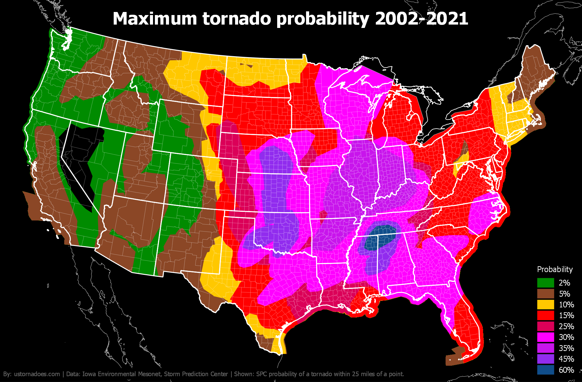
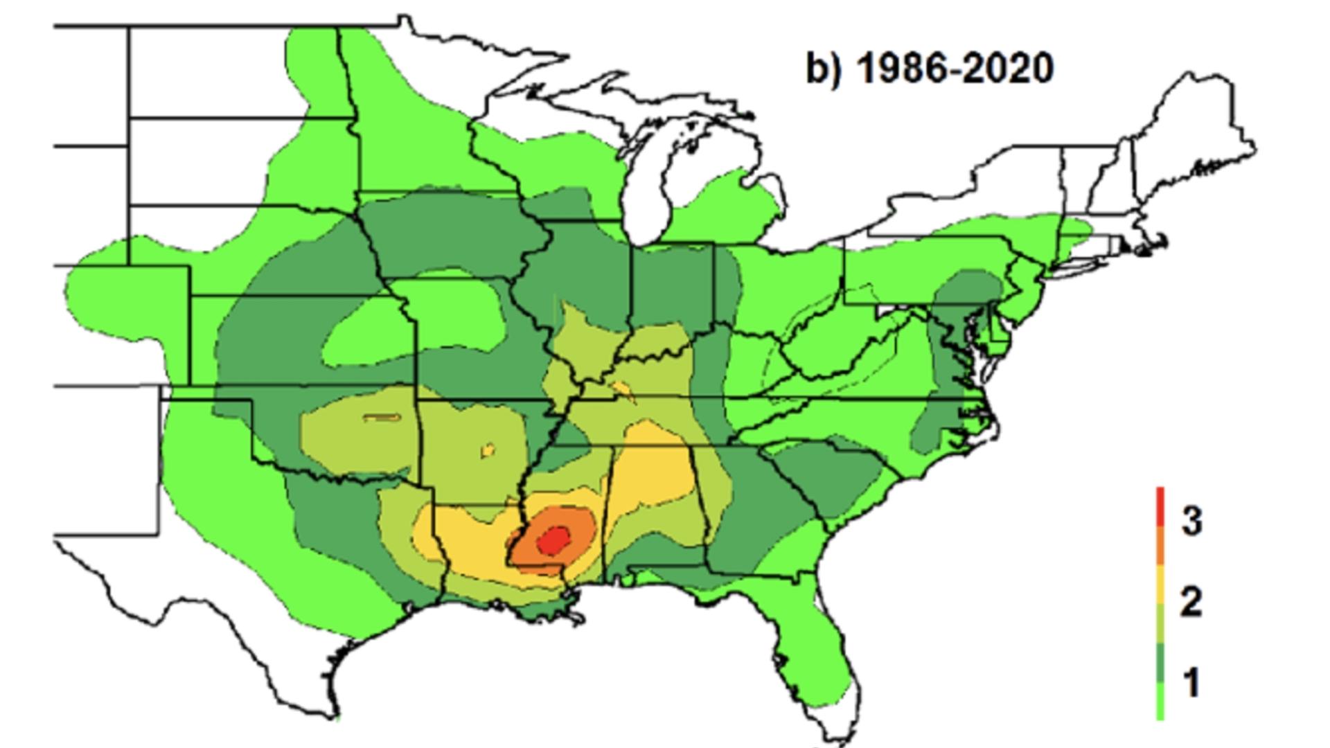
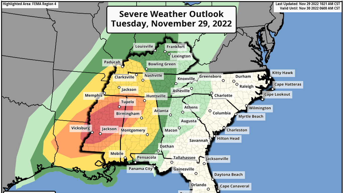
Navigating the Alabama tornado risk map requires a clear understanding of historical meteorological data, geographic vulnerability zones, and the specific severe weather patterns that impact the state year-round. By examining regional risk gradients, leveraging official meteorological data sources, and understanding building safety standards, residents can significantly enhance their preparedness for severe convective storms.
The Geography of Severe Weather: Why Alabama Faces Elevated Tornado Risk
Alabama is widely recognized by meteorologists and emergency management professionals as one of the most volatile regions in the United States for severe weather. While the American Midwest frequently dominates national discussions regarding tornadoes, the Deep South—and Alabama in particular—presents unique meteorological challenges that elevate its overall risk profile. Understanding these dynamics is essential for interpreting any tornado risk map accurately.
The state’s geographical position creates a natural collision zone for contrasting air masses. Warm, moisture-laden air flows northward from the Gulf of Mexico, while cold, dry air sweeps down from the continental interior and the Rocky Mountains. When these powerful air masses intersect over Alabama's varied terrain, they generate high levels of convective available potential energy (CAPE) and significant vertical wind shear—the two primary ingredients required to spin up violent supercell thunderstorms.
Furthermore, Alabama experiences two distinct peak tornado seasons. The primary peak occurs during the spring months (March through May), which aligns with the national trend. However, the state also faces a secondary, highly dangerous peak during late autumn and early winter (November through January). During these cooler months, strong jet stream dynamics can drive severe weather systems rapidly across the region, often occurring during the overnight hours when residents are asleep and traditional visual cues of danger are obscured.
Decoding Risk Zones: How Meteorologists Classify Alabama's Hazard Levels
A standard Alabama tornado risk map is not merely a reflection of past storms; it is a probabilistic model derived from decades of observational data, atmospheric modeling, and climatological studies. Organizations such as the National Oceanic and Atmospheric Administration (NOAA) and the Storm Prediction Center (SPC) categorize risk using structured frameworks that help communities allocate resources and focus public safety messaging.
When evaluating risk maps, meteorologists look at frequency, intensity, and the density of historical touchdown tracks. The state is traditionally divided into several sub-regions based on these metrics:
- Northern Alabama (Tennessee Valley): This region, encompassing cities like Huntsville and Florence, is heavily impacted by Dixie Alley dynamics. It experiences frequent high-shear environments, particularly during spring frontal passages.
- Central Alabama (Greater Birmingham and surrounding counties): Characterized by high population density and frequent nocturnal severe weather events, this area often records significant tornado tracks due to persistent atmospheric instability corridors.
- Southern Alabama and the Coastal Plain: While tornadoes can occur here at any time, this region frequently deals with land-falling tropical systems and hurricanes during the summer and autumn months, which can spawn quick-forming, short-lived tornadoes embedded within outer rainbands.
| Region | Primary Severe Season | Dominant Storm Types | Typical Warning Lead Time |
|---|---|---|---|
| North Alabama | March – May, November – December | Supercells, Squall Lines | 12 – 18 Minutes |
| Central Alabama | March – May, November – January | Discrete Supercells, Bow Echoes | 10 – 15 Minutes |
| South Alabama | February – April, June – October (Tropical) | Tropical Remnants, Supercells | 8 – 12 Minutes |
Official Data Sources and Interactive Mapping Tools
Relying on accurate, real-time, and historical data is critical when evaluating structural vulnerability or planning community safety measures. Several authoritative platforms provide access to comprehensive tornado risk maps and live meteorological tracking.
The Storm Prediction Center (SPC)
The Storm Prediction Center, a division of the National Weather Service (NWS), provides daily convective outlooks that highlight severe weather probabilities across Alabama on a scale from Marginal (Level 1/5) to High (Level 5/5). These maps are updated multiple times a day and serve as the primary baseline for regional emergency declarations.
NWS Local Forecast Offices
Alabama is served by multiple National Weather Service forecast offices, including Birmingham, Huntsville, Mobile, and Montgomery. Each local office maintains detailed climatological archives, local storm reports, and historical tornado track maps specific to their respective counties. Consulting local NWS office dashboards allows residents to see micro-geographical trends, such as historical corridors where tornadoes have historically recurred due to topographical features like river valleys or ridges.
State and Local Emergency Management Agencies
The Alabama Emergency Management Agency (AEMA) provides planning resources, community shelter locators, and preparedness guidelines tailored to the state's unique threat environment. Local county EMA offices often supplement state data with granular maps detailing local storm shelter locations and evacuation routes.
Structural Vulnerability and Mitigation Strategies
Understanding where your county falls on an Alabama tornado risk map directly informs structural engineering and home safety decisions. Because tornadoes in the region can reach EF4 and EF5 intensities with wind speeds exceeding 200 miles per hour, standard residential construction methods are frequently insufficient to withstand direct impacts.
Safe Rooms and Storm Shelters
For homeowners residing in high-risk zones across central and northern Alabama, investing in a FEMA-compliant safe room or an underground storm shelter is a primary mitigation step. Above-ground safe rooms must be anchored directly to a reinforced concrete slab using engineered anchoring systems capable of resisting extreme uplift and lateral wind loads.
Retrofitting Existing Homes
If building a standalone shelter is not feasible, homeowners can undertake structural retrofitting to improve a house's overall wind resistance:
- Roof-to-Wall Connections: Installing hurricane ties or metal clips to secure roof rafters to the top plates of exterior walls, preventing the roof structure from lifting off during high winds.
- Garage Door Reinforcement: Garage doors are often the weakest structural point in a home; when they fail under wind pressure, internal pressure builds and can cause catastrophic roof and wall failure. Installing a vertical brace kit or replacing the door with a wind-rated model significantly improves survivability.
- Impact-Resistant Glazing: Protecting windows and glass doors from flying debris prevents pressure equalization issues that compromise interior structural integrity.
Frequently Asked Questions
What is the most dangerous time of year for tornadoes in Alabama?
Alabama has two distinct peak seasons. The primary peak occurs in spring (March through May), driven by strong temperature contrasts and dynamic cold fronts. The secondary peak occurs in late autumn and early winter (November through January), during which storms are often fast-moving, high-shear events that frequently occur at night.
Are certain counties in Alabama at higher risk than others?
While no county in Alabama is completely immune to tornadoes, historical tracking data indicates that counties across north and central Alabama—often referred to as part of "Dixie Alley"—experience a higher frequency of violent, long-track tornadoes compared to some coastal regions, though the entire state remains vulnerable year-round.
How often are Alabama tornado risk maps updated?
Long-term climatological risk maps are periodically updated by meteorological institutions using decades of data. However, short-term convective outlook and risk maps provided by the Storm Prediction Center are updated multiple times daily to reflect changing atmospheric conditions.
What is the difference between a tornado watch and a tornado warning?
A tornado watch means that atmospheric conditions are favorable for the development of tornadoes in and close to the designated area. Residents should review emergency plans and verify shelter readiness. A tornado warning indicates that a tornado has been indicated by radar or sighted by spotters, meaning immediate protective action must be taken.
Where can I find verified historical tornado tracks for my specific property?
The National Weather Service maintains public GIS databases and historical storm event search tools, such as the NWS Damage Assessment Toolkit, which allows users to search past tornado tracks by county, date, and intensity rating.
Practical Next Steps for Preparedness
Consulting an Alabama tornado risk map is the first step in establishing a comprehensive household safety plan. Residents should identify their local risk tier, locate the nearest designated public or private storm shelter, assemble a portable emergency supply kit containing water, non-perishable food, medications, and battery-powered weather radios, and establish a reliable multi-source warning system to receive alerts day or night. Proactive planning remains the most effective defense against the unpredictable nature of southern severe weather.